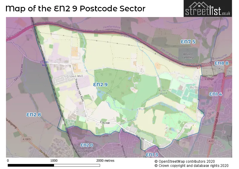
The EN2 9 postcode sector stands on the Greater London and Hertfordshire border.
Did you know? According to the 2021 Census, the EN2 9 postcode sector is home to a bustling 1,340 residents!
Given that each sector allows for 400 unique postcode combinations. Letters C, I, K, M, O and V are not allowed in the last two letters of a postcode. With 90 postcodes already in use, this leaves 310 units available.
The EN2 9 postal code covers the settlement of ENFIELD .
The EN2 9 Postcode shares a border with EN1 3 (ENFIELD ), EN1 4 (ENFIELD ), EN2 0 (ENFIELD ), EN2 8 (ENFIELD ) and EN7 5 (CHESHUNT , GOFFS OAK , WALTHAM CROSS ).
The sector is within the post town of ENFIELD.
EN2 9 is a postcode sector within the EN2 postcode district which is within the EN Enfield postcode area.
The Royal Mail delivery office for the EN2 9 postal sector is the Enfield Delivery Office.
The area of the EN2 9 postcode sector is 2.61 square miles which is 6.75 square kilometres or 1,667.93 square acres.
The EN2 9 postcode sector is crossed by the M25 motorway.
Waterways within the EN2 9 postcode sector include the Turkey Brook, Cuffley Brook.

Map of the EN2 9 Postcode Sector
Explore the EN2 9 postcode sector by using our free interactive map.
| E | N | 2 | - | 9 | X | X |
| E | N | 2 | Space | 9 | Letter | Letter |
Official List of Streets
ENFIELD (26 Streets)
Unofficial Streets or Alternative Spellings
ENFIELD
BROWNING ROAD BURNHAM CLOSE GOAT LANE HILLSIDE CRESCENT KILVINTON DRIVE MORLEY HILL OLD FORGE ROAD RUSSELL ROAD TURKEY STREET BIULLS CROSS RIDE BURNTFARM RIDE CATTLEGATE ROAD CREWS HILL GILMOUR CLOSE GOLF DRIVE MAIDENS BRIDGE NEW RIVER PATH PORTLAND DRIVE ROSSENDALE DRIVE ST GEORGES ROADWALTHAM CROSS
BULLS CROSS RIDENorthaw
CATTLEGATE ROADWeather Forecast for EN2 9
Press Button to Show Forecast for Myddelton House
| Time Period | Icon | Description | Temperature | Rain Probability | Wind |
|---|---|---|---|---|---|
| 03:00 to 06:00 | Partly cloudy (night) | 12.0°C (feels like 12.0°C) | 0.00% | S 2 mph | |
| 06:00 to 09:00 | Partly cloudy (day) | 14.0°C (feels like 14.0°C) | 0.00% | ESE 2 mph | |
| 09:00 to 12:00 | Cloudy | 18.0°C (feels like 17.0°C) | 4.00% | SE 4 mph | |
| 12:00 to 15:00 | Cloudy | 21.0°C (feels like 20.0°C) | 3.00% | SE 4 mph | |
| 15:00 to 18:00 | Cloudy | 22.0°C (feels like 20.0°C) | 3.00% | ESE 9 mph | |
| 18:00 to 21:00 | Sunny day | 19.0°C (feels like 17.0°C) | 0.00% | ESE 9 mph | |
| 21:00 to 00:00 | Partly cloudy (night) | 15.0°C (feels like 14.0°C) | 0.00% | E 7 mph |
Press Button to Show Forecast for Myddelton House
| Time Period | Icon | Description | Temperature | Rain Probability | Wind |
|---|---|---|---|---|---|
| 00:00 to 03:00 | Clear night | 12.0°C (feels like 12.0°C) | 0.00% | E 4 mph | |
| 03:00 to 06:00 | Clear night | 11.0°C (feels like 11.0°C) | 0.00% | E 4 mph | |
| 06:00 to 09:00 | Cloudy | 12.0°C (feels like 11.0°C) | 4.00% | ENE 4 mph | |
| 09:00 to 12:00 | Partly cloudy (day) | 18.0°C (feels like 17.0°C) | 0.00% | E 4 mph | |
| 12:00 to 15:00 | Partly cloudy (day) | 22.0°C (feels like 20.0°C) | 1.00% | ESE 7 mph | |
| 15:00 to 18:00 | Cloudy | 22.0°C (feels like 20.0°C) | 4.00% | ESE 9 mph | |
| 18:00 to 21:00 | Partly cloudy (day) | 20.0°C (feels like 19.0°C) | 1.00% | ESE 9 mph | |
| 21:00 to 00:00 | Clear night | 16.0°C (feels like 15.0°C) | 0.00% | ESE 7 mph |
Press Button to Show Forecast for Myddelton House
| Time Period | Icon | Description | Temperature | Rain Probability | Wind |
|---|---|---|---|---|---|
| 00:00 to 03:00 | Clear night | 14.0°C (feels like 13.0°C) | 0.00% | E 7 mph | |
| 03:00 to 06:00 | Clear night | 13.0°C (feels like 13.0°C) | 0.00% | E 4 mph | |
| 06:00 to 09:00 | Partly cloudy (day) | 14.0°C (feels like 14.0°C) | 1.00% | E 4 mph | |
| 09:00 to 12:00 | Partly cloudy (day) | 19.0°C (feels like 19.0°C) | 1.00% | ESE 4 mph | |
| 12:00 to 15:00 | Cloudy | 23.0°C (feels like 21.0°C) | 6.00% | SSE 9 mph | |
| 15:00 to 18:00 | Cloudy | 23.0°C (feels like 21.0°C) | 9.00% | SSE 9 mph | |
| 18:00 to 21:00 | Cloudy | 21.0°C (feels like 20.0°C) | 10.00% | SSE 9 mph | |
| 21:00 to 00:00 | Cloudy | 18.0°C (feels like 17.0°C) | 9.00% | S 7 mph |
Press Button to Show Forecast for Myddelton House
| Time Period | Icon | Description | Temperature | Rain Probability | Wind |
|---|---|---|---|---|---|
| 00:00 to 03:00 | Cloudy | 16.0°C (feels like 15.0°C) | 13.00% | S 7 mph | |
| 03:00 to 06:00 | Cloudy | 15.0°C (feels like 14.0°C) | 13.00% | S 7 mph | |
| 06:00 to 09:00 | Cloudy | 15.0°C (feels like 14.0°C) | 14.00% | S 7 mph | |
| 09:00 to 12:00 | Cloudy | 16.0°C (feels like 15.0°C) | 17.00% | SSW 9 mph | |
| 12:00 to 15:00 | Cloudy | 18.0°C (feels like 16.0°C) | 18.00% | S 11 mph | |
| 15:00 to 18:00 | Light rain shower (day) | 18.0°C (feels like 16.0°C) | 38.00% | SSW 11 mph | |
| 18:00 to 21:00 | Light rain shower (day) | 17.0°C (feels like 15.0°C) | 35.00% | SSW 9 mph | |
| 21:00 to 00:00 | Cloudy | 15.0°C (feels like 14.0°C) | 12.00% | SSW 9 mph |
Schools and Places of Education Within the EN2 9 Postcode Sector
Forty Hill CofE Primary School
Voluntary aided school
Forty Hill, Enfield, , EN2 9EY
Head: Ms Jonquil Izard
Ofsted Rating: Good
Inspection: 2021-09-15 (968 days ago)
Website: Visit Forty Hill CofE Primary School Website
Phone: 02083630760
Number of Pupils: 227
St John's CofE Primary School
Voluntary aided school
St Johns Ce Primary School, Enfield, , EN2 9BD
Head: Mrs Susan Notley
Ofsted Rating: Good
Inspection: 2022-07-20 (660 days ago)
Website: Visit St John's CofE Primary School Website
Phone: 02083634709
Number of Pupils: 106
House Prices in the EN2 9 Postcode Sector
| Type of Property | 2018 Average | 2018 Sales | 2017 Average | 2017 Sales | 2016 Average | 2016 Sales | 2015 Average | 2015 Sales |
|---|---|---|---|---|---|---|---|---|
| Detached | £1,033,197 | 12 | £907,318 | 8 | £787,250 | 10 | £709,375 | 8 |
| Semi-Detached | £420,000 | 1 | £645,000 | 3 | £611,875 | 8 | £697,500 | 4 |
| Terraced | £325,000 | 1 | £517,500 | 5 | £451,100 | 5 | £517,381 | 3 |
| Flats | £321,667 | 3 | £0 | 0 | £312,374 | 4 | £302,333 | 3 |
Important Postcodes EN2 9 in the Postcode Sector
EN2 9BD is the postcode for St. Johns C of E Primary School, Theobalds Park Road
EN2 9EY is the postcode for Forty Hill C of E School, Forty Hill
EN2 9HA is the postcode for Forty Hall, Forty Hill
EN2 9HG is the postcode for Lee Valley Park Information Service, Myddelton House, Bulls Cross, MYDDELTON HOUSE, BULLS CROSS, and ABERCROMBIE LODGE, Lee Valley Park Information Service, Myddelton House, Bulls Cross
EN2 9HH is the postcode for Whitewebbs Park Golf Course, Whitewebbs Lane
| The EN2 9 Sector is within these Local Authorities |
|
|---|---|
| The EN2 9 Sector is within these Counties |
|
| The EN2 9 Sector is within these Water Company Areas |
|