
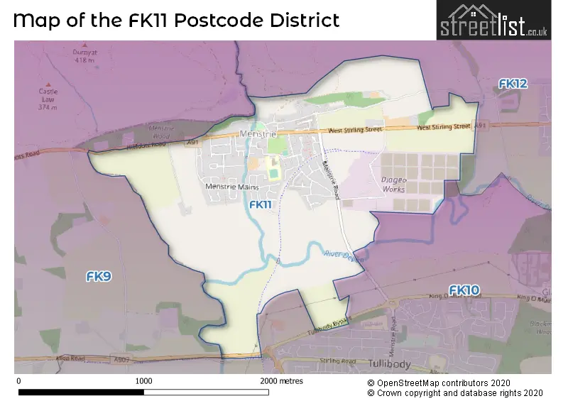
Map of the Postcode District
Explore the postcode district by using our interactive map.
Your support helps keep this site running!
If you enjoy using this website, consider buying me a coffee to help cover hosting costs.
The postcode district located in the FK Falkirk postal area , FK11 has a population of 2,804 residents according to the 2011 Scotland Census.
The area of the district is 1.43 square miles (3.69 square kilometers or 912.16 acres).
Where is the FK11 District?
To give you an idea where the district is located we have created the following table showing nearby towns.
Nearest Towns to FK11
| Town | Distance (miles) | Direction |
|---|---|---|
| Alva | 1.80 | ENE |
| Alloa | 3.09 | SE |
| Bridge of Allan | 3.88 | W |
| Stirling | 3.99 | SW |
| Tillicoultry | 4.23 | E |
| Clackmannan | 4.63 | SE |
| Dunblane | 5.29 | WNW |
| Dollar | 6.91 | E |
| Doune | 8.40 | WNW |
| Denny | 8.93 | SSW |
| Grangemouth | 10.12 | SSE |
| Culross | 10.55 | SE |
| Falkirk | 10.55 | SSE |
| Auchterarder | 11.66 | NNE |
| Bo'ness | 13.01 | SE |
| Kilsyth | 14.24 | SW |
| Cumbernauld | 15.10 | SSW |
| Linlithgow | 15.21 | SE |
| Callander | 15.54 | WNW |
| Crieff | 15.60 | N |
The post town for this district is MENSTRIE.
Postcode Information for District FK11 (Total Geographical Postcodes: 75)
| Location | Post Town | Sector | Number of Postcodes |
|---|---|---|---|
| MENSTRIE | MENSTRIE | FK11 7 | 75 |
The primary settlement in the FK11 postcode district is Menstrie, located in the county of Clackmannan in Scotland. There are no other significant settlements mentioned in the data provided. Menstrie is also the post town with the highest postcode count in the FK11 district.
When it comes to local government, postal geography often disregards political borders. However, this district intersects the following councils: the district mostly encompasses the Clackmannanshire area with a total of 75 postal codes.
The FK11 postal code covers the settlement of MENSTRIE.
The FK11 Postcode shares a border with FK9 (STIRLING, Bridge Of Allan, Blairdrummond), FK12 (ALVA) and FK10 (ALLOA, Tullibody, Sauchie).
Postcode Sectors


Stations in the Sector
No stations found in this postcode district.
Accessable Motorway Junctions
M9 J9
Average Driving Time from within the district: 9.28
Average Driving Distance: 7.52
Number of Postcodes that can access the Motorway Junction: 75
M9 J10
Average Driving Time from within the district: 10.81
Average Driving Distance: 6.07
Number of Postcodes that can access the Motorway Junction: 75
M876 J3
Average Driving Time from within the district: 15.36
Average Driving Distance: 11.21
Number of Postcodes that can access the Motorway Junction: 5
M80 J9
Average Driving Time from within the district: 15.59
Average Driving Distance: 11.01
Number of Postcodes that can access the Motorway Junction: 75
Weather Forecast for Alva
| Time Period | Icon | Description | Temperature | Rain Probability | Wind |
|---|---|---|---|---|---|
| 12:00 to 15:00 | Cloudy | 12.0°C (feels like 10.0°C) | 13.00% | W 11 mph | |
| 15:00 to 18:00 | Sunny day | 12.0°C (feels like 10.0°C) | 2.00% | WSW 9 mph | |
| 18:00 to 21:00 | Partly cloudy (night) | 9.0°C (feels like 9.0°C) | 4.00% | WSW 4 mph | |
| 21:00 to 00:00 | Cloudy | 9.0°C (feels like 8.0°C) | 4.00% | SW 4 mph |
| Time Period | Icon | Description | Temperature | Rain Probability | Wind |
|---|---|---|---|---|---|
| 00:00 to 03:00 | Cloudy | 9.0°C (feels like 8.0°C) | 5.00% | SW 4 mph | |
| 03:00 to 06:00 | Cloudy | 10.0°C (feels like 9.0°C) | 13.00% | WSW 7 mph | |
| 06:00 to 09:00 | Overcast | 10.0°C (feels like 9.0°C) | 14.00% | SW 7 mph | |
| 09:00 to 12:00 | Overcast | 11.0°C (feels like 10.0°C) | 9.00% | SW 7 mph | |
| 12:00 to 15:00 | Overcast | 13.0°C (feels like 11.0°C) | 8.00% | SW 11 mph | |
| 15:00 to 18:00 | Cloudy | 14.0°C (feels like 12.0°C) | 4.00% | SSW 9 mph | |
| 18:00 to 21:00 | Cloudy | 12.0°C (feels like 10.0°C) | 5.00% | SSW 9 mph | |
| 21:00 to 00:00 | Cloudy | 12.0°C (feels like 10.0°C) | 9.00% | S 9 mph |
| Time Period | Icon | Description | Temperature | Rain Probability | Wind |
|---|---|---|---|---|---|
| 00:00 to 03:00 | Overcast | 12.0°C (feels like 11.0°C) | 9.00% | SSE 9 mph | |
| 03:00 to 06:00 | Overcast | 12.0°C (feels like 10.0°C) | 9.00% | S 13 mph | |
| 06:00 to 09:00 | Cloudy | 11.0°C (feels like 9.0°C) | 5.00% | S 13 mph | |
| 09:00 to 12:00 | Overcast | 12.0°C (feels like 9.0°C) | 8.00% | S 13 mph | |
| 12:00 to 15:00 | Overcast | 13.0°C (feels like 10.0°C) | 11.00% | S 13 mph | |
| 15:00 to 18:00 | Overcast | 13.0°C (feels like 11.0°C) | 13.00% | S 13 mph | |
| 18:00 to 21:00 | Overcast | 13.0°C (feels like 11.0°C) | 16.00% | S 11 mph | |
| 21:00 to 00:00 | Overcast | 12.0°C (feels like 11.0°C) | 22.00% | S 9 mph |
| Time Period | Icon | Description | Temperature | Rain Probability | Wind |
|---|---|---|---|---|---|
| 00:00 to 03:00 | Light rain | 12.0°C (feels like 11.0°C) | 52.00% | S 7 mph | |
| 03:00 to 06:00 | Light rain | 11.0°C (feels like 10.0°C) | 50.00% | SW 7 mph | |
| 06:00 to 09:00 | Light rain | 11.0°C (feels like 10.0°C) | 47.00% | ENE 7 mph | |
| 09:00 to 12:00 | Light rain | 11.0°C (feels like 9.0°C) | 48.00% | N 9 mph | |
| 12:00 to 15:00 | Light rain | 11.0°C (feels like 9.0°C) | 50.00% | NNE 9 mph | |
| 15:00 to 18:00 | Light rain shower (day) | 11.0°C (feels like 9.0°C) | 39.00% | NNW 9 mph | |
| 18:00 to 21:00 | Light rain shower (night) | 10.0°C (feels like 8.0°C) | 33.00% | NNW 9 mph | |
| 21:00 to 00:00 | Partly cloudy (night) | 9.0°C (feels like 8.0°C) | 7.00% | NNW 7 mph |
| Time Period | Icon | Description | Temperature | Rain Probability | Wind |
|---|---|---|---|---|---|
| 00:00 to 03:00 | Fog | 9.0°C (feels like 7.0°C) | 20.00% | W 7 mph | |
| 03:00 to 06:00 | Drizzle | 9.0°C (feels like 7.0°C) | 33.00% | S 7 mph | |
| 06:00 to 09:00 | Overcast | 9.0°C (feels like 7.0°C) | 23.00% | SW 9 mph | |
| 09:00 to 12:00 | Overcast | 10.0°C (feels like 7.0°C) | 24.00% | SW 11 mph | |
| 12:00 to 15:00 | Light rain | 10.0°C (feels like 8.0°C) | 46.00% | SW 13 mph | |
| 15:00 to 18:00 | Cloudy | 10.0°C (feels like 7.0°C) | 17.00% | SW 13 mph | |
| 18:00 to 21:00 | Clear night | 9.0°C (feels like 6.0°C) | 9.00% | WSW 11 mph | |
| 21:00 to 00:00 | Clear night | 8.0°C (feels like 5.0°C) | 10.00% | SW 11 mph |
| Postal Sector | Delivery Office |
|---|---|
| FK11 7 | Alloa Delivery Office |
| F | K | 1 | 1 | - | X | X | X |
| F | K | 1 | 1 | Space | Numeric | Letter | Letter |
Street List for the FK11 District
Current Monthly Rental Prices
| # Bedrooms | Min Price | Max Price | Avg Price |
|---|
Current House Prices
| # Bedrooms | Min Price | Max Price | Avg Price |
|---|---|---|---|
| 1 | £47,000 | £47,000 | £47,000 |
| 2 | £89,995 | £89,995 | £89,995 |
Estate Agents
| Logo | Name | Brand Name | Address | Contact Number |
|---|---|---|---|---|
 | Alloa | O'Malley Property | 6 Primrose Street, Alloa, FK10 1JG | 01259 235960 |
 | Edinburgh | McEwan Fraser Legal | Claremont House 130 East Claremont Street Edinburgh EH7 4LB | 0131 381 4292 |