The FY2 9 postcode sector is within the county of Lancashire.
Did you know? According to the 2021 Census, the FY2 9 postcode sector is home to a bustling 9,992 residents!
Given that each sector allows for 400 unique postcode combinations. Letters C, I, K, M, O and V are not allowed in the last two letters of a postcode. With 240 postcodes already in use, this leaves 160 units available.
The largest settlements in the FY2 9 postal code are Bispham and BLACKPOOL.
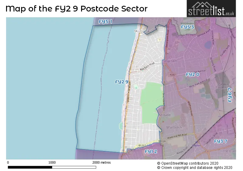
The FY2 9 Postcode shares a border with FY5 1 (THORNTON-CLEVELEYS), FY1 2 (BLACKPOOL) and FY2 0 (BLACKPOOL, Bispham).
The sector is within the post town of BLACKPOOL.
FY2 9 is a postcode sector within the FY2 postcode district which is within the FY The Fylde postcode area.
The Royal Mail delivery office for the FY2 9 postal sector is the Blackpool Delivery Office.
The area of the FY2 9 postcode sector is 0.86 square miles which is 2.22 square kilometres or 549.72 square acres.

Map of the FY2 9 Postcode Sector
Explore the FY2 9 postcode sector by using our free interactive map.
| F | Y | 2 | - | 9 | X | X |
| F | Y | 2 | Space | 9 | Letter | Letter |
Official List of Streets
BLACKPOOL (29 Streets)
Bispham (57 Streets)
Unofficial Streets or Alternative Spellings
BLACKPOOL
HODGSON ROAD LINKS ROAD ORMOND AVENUE RIVERSLEIGH AVENUE SEAFIELD ROADTHORNTON-CLEVELEYS
CLOVELLY AVENUE DELPHENE AVENUE NORBRECK ROAD ADMIRAL HEIGHTS ADMIRAL POINT ADMIRAL VIEW ARGYLL COURT CLIFF COURT HILARY AVENUE LOWER WALK NORBRECK COURT VINE COURTBispham
ADMIRAL GARDENS ASHLEY CLOSE DEVONSHIRE ROAD GALWAY AVENUE MUNSTER AVENUEWeather Forecast for FY2 9
Press Button to Show Forecast for Blackpool
| Time Period | Icon | Description | Temperature | Rain Probability | Wind |
|---|---|---|---|---|---|
| 06:00 to 09:00 | Sunny day | 3.0°C (feels like 0.0°C) | 1.00% | E 7 mph | |
| 09:00 to 12:00 | Partly cloudy (day) | 7.0°C (feels like 6.0°C) | 1.00% | E 4 mph | |
| 12:00 to 15:00 | Cloudy | 9.0°C (feels like 7.0°C) | 8.00% | NE 7 mph | |
| 15:00 to 18:00 | Cloudy | 9.0°C (feels like 8.0°C) | 8.00% | NE 4 mph | |
| 18:00 to 21:00 | Cloudy | 9.0°C (feels like 8.0°C) | 5.00% | NNE 4 mph | |
| 21:00 to 00:00 | Cloudy | 6.0°C (feels like 3.0°C) | 6.00% | NE 9 mph |
Press Button to Show Forecast for Blackpool
| Time Period | Icon | Description | Temperature | Rain Probability | Wind |
|---|---|---|---|---|---|
| 00:00 to 03:00 | Partly cloudy (night) | 4.0°C (feels like 2.0°C) | 3.00% | E 7 mph | |
| 03:00 to 06:00 | Partly cloudy (night) | 3.0°C (feels like 0.0°C) | 5.00% | E 7 mph | |
| 06:00 to 09:00 | Partly cloudy (day) | 4.0°C (feels like 1.0°C) | 4.00% | E 7 mph | |
| 09:00 to 12:00 | Partly cloudy (day) | 8.0°C (feels like 6.0°C) | 5.00% | ESE 9 mph | |
| 12:00 to 15:00 | Overcast | 10.0°C (feels like 8.0°C) | 12.00% | E 9 mph | |
| 15:00 to 18:00 | Cloudy | 11.0°C (feels like 9.0°C) | 13.00% | ENE 9 mph | |
| 18:00 to 21:00 | Cloudy | 10.0°C (feels like 7.0°C) | 10.00% | ENE 9 mph | |
| 21:00 to 00:00 | Partly cloudy (night) | 7.0°C (feels like 4.0°C) | 10.00% | NE 9 mph |
Press Button to Show Forecast for Blackpool
| Time Period | Icon | Description | Temperature | Rain Probability | Wind |
|---|---|---|---|---|---|
| 00:00 to 03:00 | Cloudy | 6.0°C (feels like 3.0°C) | 15.00% | NE 9 mph | |
| 03:00 to 06:00 | Cloudy | 6.0°C (feels like 3.0°C) | 14.00% | NNE 11 mph | |
| 06:00 to 09:00 | Light rain | 7.0°C (feels like 3.0°C) | 45.00% | N 11 mph | |
| 09:00 to 12:00 | Light rain | 8.0°C (feels like 5.0°C) | 49.00% | NNE 11 mph | |
| 12:00 to 15:00 | Cloudy | 9.0°C (feels like 6.0°C) | 20.00% | N 11 mph | |
| 15:00 to 18:00 | Light rain | 9.0°C (feels like 7.0°C) | 51.00% | NNW 11 mph | |
| 18:00 to 21:00 | Partly cloudy (day) | 10.0°C (feels like 7.0°C) | 13.00% | NNW 11 mph | |
| 21:00 to 00:00 | Clear night | 7.0°C (feels like 5.0°C) | 9.00% | NW 9 mph |
Schools and Places of Education Within the FY2 9 Postcode Sector
Westcliff Primary Academy
Academy converter
Crawford Avenue, Blackpool, Lancashire, FY2 9BY
Head: Mrs Amanda Stokes
Ofsted Rating: Good
Inspection: 2022-12-14 (499 days ago)
Website: Visit Westcliff Primary Academy Website
Phone: 01253353792
Number of Pupils: 220
House Prices in the FY2 9 Postcode Sector
| Type of Property | 2018 Average | 2018 Sales | 2017 Average | 2017 Sales | 2016 Average | 2016 Sales | 2015 Average | 2015 Sales |
|---|---|---|---|---|---|---|---|---|
| Detached | £211,093 | 21 | £210,841 | 27 | £188,030 | 15 | £178,100 | 20 |
| Semi-Detached | £147,744 | 106 | £141,657 | 111 | £134,543 | 103 | £128,432 | 105 |
| Terraced | £107,883 | 36 | £113,196 | 39 | £112,793 | 37 | £112,438 | 33 |
| Flats | £94,302 | 92 | £98,678 | 36 | £102,120 | 35 | £90,738 | 32 |
Important Postcodes FY2 9 in the Postcode Sector
FY2 9BY is the postcode for Westcliffe Primary School, Crawford Avenue, and Westcliff Primary, Crawford Avenue
FY2 9EA is the postcode for Lancashire Fire & Rescue Service, Fire Station, Red Bank Road
FY2 9RZ is the postcode for Langdale Free School, 95 Warbreck Drive
| The FY2 9 Sector is within these Local Authorities |
|
|---|---|
| The FY2 9 Sector is within these Counties |
|
| The FY2 9 Sector is within these Water Company Areas |
|