GL10 3AR is a postal code used within the United Kingdom for delivering mail.
Postcodes are made up of two parts. The part before the space (GL10) is called the outward code. The part after the space (3AR) is called the inward code. The letters C, I, K, M, O and V are not allowed in the inward code. In addition to the inward and outward code, the postcode can be broken up into four parts:
- Postal Area. In our case GL which means Gloucester.
- Postal District. In our case GL10.
- Postal Sector. In our case GL10 3.
- Postcode Unit. The last two letters. In our case AR.
The regional mail center for the post area GL is the South West Distribution Centre, which is located at Western Approach, Distribution Park, Severn Beach, BRISTOL, BS35 4GG.
The final port of call for any post addressed to the GL10 3AR postcode is the local delivery office (DO) which is STROUD DO. Here the post will be sorted ready for delivery.
The properties in the GL10 3AR postcode have the street address of Cotswold Avenue
Did you know? According to the 2021 Census, the GL10 3AR postcode is home to a bustling 26 residents!
It is situated within the post town of STONEHOUSE within the old postal county of Gloucestershire.
GL10 3AR is within the village of Eastington.
The GL10 3AR postcode area is composed of 100% residential properties, 0% commercial properties, and 0% public properties.
According to our data. Most dwellings in GL10 3AR are houses. Of these houses, most are semi-detached. The remainder are mid-terraced.
Most properties in GL10 3AR are owned by the occupiers with the rest being social housing.

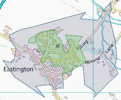
Interactive Mapping Showing UPRNs within the GL10 3AR Postcode Boundaries
Use the search box to search for other postcodes or places.
| Property Type | Percentage |
|---|---|
| Residential | 100% |
| Commercial | 0% |
| Public | 0% |
Map Coordinates for GL10 3AR
| Latitude | 51.7474139798 |
|---|---|
| Longitude | -2.32509146252 |
Ordnance Survey Maps for GL10 3AR
| Map Series | Amazon | Ordnance Survey |
| Explorer 1:25,000 168 Stroud, Tetbury and Malmesbury | Check Price on Amazon | Buy Direct from the Ordnance Survey |
| Explorer 1:25,000 179 Gloucester, Cheltenham and Stroud | Check Price on Amazon | Buy Direct from the Ordnance Survey |
| Landranger 1:50,000 162 Gloucester & Forest of Dean | Check Price on Amazon | Buy Direct from the Ordnance Survey |
Weather Forecast for GL10 3AR
Fri 3rd May
Press Button to Show Forecast for Stonehouse
| Time Period | Icon | Description | Temperature | Rain Probability | Wind |
|---|---|---|---|---|---|
| 00:00 to 03:00 | Light rain | 11.0°C (feels like 9.0°C) | 47.00% | WSW 9 mph | |
| 03:00 to 06:00 | Light rain | 10.0°C (feels like 8.0°C) | 51.00% | W 9 mph | |
| 06:00 to 09:00 | Light rain | 10.0°C (feels like 8.0°C) | 52.00% | WSW 9 mph | |
| 09:00 to 12:00 | Overcast | 11.0°C (feels like 9.0°C) | 21.00% | WSW 11 mph | |
| 12:00 to 15:00 | Cloudy | 13.0°C (feels like 11.0°C) | 12.00% | WSW 13 mph | |
| 15:00 to 18:00 | Cloudy | 14.0°C (feels like 11.0°C) | 8.00% | WSW 13 mph | |
| 18:00 to 21:00 | Cloudy | 13.0°C (feels like 11.0°C) | 7.00% | WSW 11 mph | |
| 21:00 to 00:00 | Partly cloudy (night) | 10.0°C (feels like 8.0°C) | 3.00% | SW 9 mph |
Sat 4th May
Press Button to Show Forecast for Stonehouse
| Time Period | Icon | Description | Temperature | Rain Probability | Wind |
|---|---|---|---|---|---|
| 00:00 to 03:00 | Clear night | 9.0°C (feels like 7.0°C) | 3.00% | SW 7 mph | |
| 03:00 to 06:00 | Clear night | 7.0°C (feels like 6.0°C) | 2.00% | S 7 mph | |
| 06:00 to 09:00 | Sunny day | 9.0°C (feels like 7.0°C) | 3.00% | S 7 mph | |
| 09:00 to 12:00 | Partly cloudy (day) | 13.0°C (feels like 11.0°C) | 7.00% | S 9 mph | |
| 12:00 to 15:00 | Partly cloudy (day) | 15.0°C (feels like 13.0°C) | 12.00% | S 9 mph | |
| 15:00 to 18:00 | Cloudy | 16.0°C (feels like 14.0°C) | 15.00% | S 11 mph | |
| 18:00 to 21:00 | Partly cloudy (day) | 14.0°C (feels like 13.0°C) | 10.00% | S 9 mph | |
| 21:00 to 00:00 | Partly cloudy (night) | 11.0°C (feels like 10.0°C) | 9.00% | S 9 mph |
Sun 5th May
Press Button to Show Forecast for Stonehouse
| Time Period | Icon | Description | Temperature | Rain Probability | Wind |
|---|---|---|---|---|---|
| 00:00 to 03:00 | Partly cloudy (night) | 10.0°C (feels like 8.0°C) | 12.00% | S 7 mph | |
| 03:00 to 06:00 | Cloudy | 9.0°C (feels like 8.0°C) | 8.00% | S 7 mph | |
| 06:00 to 09:00 | Cloudy | 10.0°C (feels like 9.0°C) | 7.00% | S 7 mph | |
| 09:00 to 12:00 | Cloudy | 13.0°C (feels like 12.0°C) | 13.00% | S 9 mph | |
| 12:00 to 15:00 | Cloudy | 16.0°C (feels like 14.0°C) | 13.00% | S 9 mph | |
| 15:00 to 18:00 | Cloudy | 16.0°C (feels like 14.0°C) | 16.00% | S 9 mph | |
| 18:00 to 21:00 | Cloudy | 15.0°C (feels like 14.0°C) | 12.00% | S 9 mph | |
| 21:00 to 00:00 | Cloudy | 12.0°C (feels like 11.0°C) | 8.00% | SW 7 mph |
What are the Broadband Speeds like in the GL10 3AR Postcode?
Download Speeds For GL10 3AR

| Average Mbps | 57.000 |
|---|---|
| Median Mbps | 62.200 |
| Maximum Mbps | 76.540 |
GL10 3AR has an average download speed of 57 Megabits per second (Mbps).
1,447 other postcode units have the same broadband speed.
35% of postcodes (416,379) have slower broadband speeds.
65% of postcodes (766,815) have faster broadband speeds.
Upload Speeds For GL10 3AR

| Average Mbps | 16.900 |
|---|---|
| Median Mbps | 19.000 |
| Maximum Mbps | 20.000 |
GL10 3AR has an average upload speed of 16.9 Megabits per second (Mbps).
7,917 other postcode units have the same upload speed.
81% of postcodes (963,596) have slower upload speeds.
18% of postcodes (213,128) have faster upload speeds.
Schools within a five minute drive of GL10 3AR Postcode
England Primary Schools
Eastington Primary School
Address: Eastington Primary School, Churchend, Eastington, Stonehouse, Gloucestershire, GL10 3SB
Distance: 0.44 miles
Contact: 01453822922
Nearest Dentists
Dentists near GL10 3AR
HIGH STREET DENTAL PRACTICE
Address: 11-13 HIGH STREET, STONEHOUSE, GLOUCESTERSHIRE, GL10 2NG
Distance: 1.81 miles
Contact: :
TOWNES & TOWNES DENTAL SURGERY
Address: 13 QUEENS ROAD, STONEHOUSE, GLOUCESTERSHIRE, GL10 2QA
Distance: 1.87 miles
Contact: :
WOODCOCK LANE DENTAL PRACTICE
Address: 2 WOODCOCK LANE, STONEHOUSE, GLOUCESTERSHIRE, GL10 2EE
Distance: 1.89 miles
Contact: :
3 CHAPEL STREET
Address: CAM, DURSLEY, GLOUCESTERSHIRE, GL11 5NX
Distance: 3.65 miles
Contact: :
DENTAL DEPARTMENT
Address: VALE COMMUNITY HOSPITAL, LISTER ROAD, KINGSMILL LANE, DURSLEY, GLOUCESTERSHIRE, GL11 4BA
Distance: 4.28 miles
Contact: :
COMMUNITY DENTAL SERVICE
Address: STROUD HEALTH CENTRE, BEECHES GREEN, STROUD, GLOUCESTERSHIRE, GL5 4BH
Distance: 4.62 miles
Contact: :
Nearest Chemists
Pharmacies near GL10 3AR
STONEHOUSE PHARMACY
Address: 31 HIGH STREET, STONEHOUSE, GLOUCESTERSHIRE, GL10 2NG
Distance: 1.81 miles
Contact: tel: 01453 823184
CAINSCROSS PHARMACY
Address: 16 CASHES GREEN ROAD, CAINSCROSS, STROUD, GLOUCESTERSHIRE, GL5 4JG
Distance: 3.54 miles
Contact: tel: 01453 759205
BOOTS
Address: 16B CHAPEL STREET, CAM, DURSLEY, GLOUCESTERSHIRE, GL11 5NU
Distance: 3.64 miles
Contact: tel: 01453 543177
TESCO INSTORE PHARMACY
Address: TESCO SUPERSTORE, STRATFORD ROAD, STROUD, GLOUCESTERSHIRE, GL5 4AG
Distance: 4.33 miles
Contact: tel: 03456 779633
STROUD FAMILY PHARMACY
Address: ROWCROFT RETREAT, ROWCROFT RETREAT, STROUD, GL5 3BE
Distance: 4.52 miles
Contact: tel: 01453 764513
BOOTS
Address: 57 HIGH STREET, STROUD, GLOUCESTERSHIRE, GL5 1AS
Distance: 4.65 miles
Contact: :
Nearest Opticians
Opticians near GL10 3AR
NORVILLE OPTICIANS
Address: ELGIN MALL, HIGH STREET, STONEHOUSE, GL10 2NA
Distance: 1.78 miles
Contact: :
SPECSAVERS (STROUD)
Address: UNIT 1, FIVE VALLEYS SHOPPING CENTRE, STROUD, GL5 1RR
Distance: 4.55 miles
Contact: :
STROUD VISION CENTRE
Address: 3 GEORGE STREET, STROUD, GLOUCESTERSHIRE, GL5 3DX
Distance: 4.59 miles
Contact: :
BOOTS OPTICIANS (STROUD)
Address: 9-10 HIGH STREET, STROUD, GLOUCESTERSHIRE, GL5 1AU
Distance: 4.62 miles
Contact: :
PAUL WESTLEY OPTICIANS
Address: 3A KENDRICK STREET, STROUD, GLOUCESTERSHIRE, GL5 1AA
Distance: 4.64 miles
Contact: :
ARMSTRONG & NORTH OPTICIANS - DURSLEY PRACTICE
Address: 24A PARSONAGE STREET, DURSLEY, GLOUCESTERSHIRE, GL11 4AA
Distance: 4.73 miles
Contact: :
Nearest GP Surgeries
Doctors near GL10 3AR
REGENT STREET SURGERY
Address: 73 REGENT STREET, STONEHOUSE, GLOUCESTERSHIRE, GL10 2AA
Distance: 1.79 miles
Contact: tel: 01453 825690
HIGH STREET MEDICAL CENTRE
Address: 31 HIGH STREET, STONEHOUSE, GLOUCESTERSHIRE, GL10 2NG
Distance: 1.81 miles
Contact: tel: 01453 822047
STONEHOUSE HEALTH CLINIC
Address: 25 HIGH STREET, STONEHOUSE, GLOUCESTERSHIRE, GL10 2NG
Distance: 1.81 miles
Contact: tel: 01453 823144
FRAMPTON SURGERY
Address: WHITMINSTER LANE, FRAMPTON ON SEVERN, GLOUCESTER, GLOUCESTERSHIRE, GL2 7HU
Distance: 2.41 miles
Contact: tel: 01452 740213
CAM & ULEY FAMILY PRACTICE
Address: THE CAM SURGERY FAIRMEAD, GLEBELANDS, CAM, DURSLEY, GL11 5NE
Distance: 3.69 miles
Contact: tel: 01453 860459
THE CAM PRACTICE - COVID LOCAL VACCINATION SERVICE
Address: GLEBELANDS, CAM, DURSLEY, GL11 5NE
Distance: 3.69 miles
Contact: :
Transport Links near GL10 3AR
Train Stations
Nearest stations for postcode: GL10 3AR
- Stonehouse
Stonehouse station, Burdett Road, Stonehouse, Gloucestershire, GL10 2JWDistance: 3.08 milesDriving Time: 5.27 minutes - Cam & Dursley
Cam & Dursley station, Box Road, near Cam, Gloucestershire, GL11 5DJDistance: 4.97 milesDriving Time: 7.88 minutes - Stroud (Gloucs)
Stroud station, Station Road, Stroud, Gloucestershire, GL5 3APDistance: 5.69 milesDriving Time: 9.55 minutes - Gloucester
Gloucester station, Bruton Way, Gloucester, Gloucestershire, GL1 1DEDistance: 10.19 milesDriving Time: 15.47 minutes - Lydney
Lydney station, Station Road, Lydney, Gloucestershire, GL15 5EWDistance: 29.48 milesDriving Time: 40.09 minutes
Distances represent the quickest route by car.
Motorway Junctions near GL10 3AR
Train Stations
Motorway Junctions near GL10 3AR
Distances represent the quickest route by car.
Who are my Elected Representatives in the GL10 3AR Postcode?
| Westminster Constituency | Stroud Co Const |
|---|---|
| Member or Parliament |  |
| Contact Details | Contact Siobhan Baillie |
| Political Party | Conservative |
What Council is the GL10 3AR Postcode in?
The Local Council for this Postcode is Stroud District Council and the County Council is Gloucestershire County Council.
Gloucestershire County Council is responsible for providing education, libraries and maintaining highways.
Stroud District Council is responsible for duties such as council tax, rubbish collection, housing, environmental health and planning.
You can visit the website for Stroud District at the following link Stroud District.How much is the Council Tax?
Stroud District Council is responsible for collecting council tax. This will vary depending on which council tax band the property falls within. You can check the council tax band at the gov.uk website.
Once you know the council tax band you can view how much Stroud District charge for that band by visiting the The Council Tax section of their website.
Planning Applications
When moving house to a new post code it is worth checking out what will be built in the neighbourhood.
Few people want to live next door to a building site, have their garden overlooked or have the views from their property ruined.
Visit the local planning department and search for planning applications in this postcode granted within the last three years or still awaiting a decision. This will give an indication of what could still be built.
Where can I find out where the nearest Library to the GL10 3AR Postcode is?
Libraries are the responsibility of Gloucestershire County Council
Visit the link for more information. Please note that some councils outsource library services to private companies and community groups ran by volunteers.
Libraries - Gloucestershire County CouncilHouse Sales in GL10 3AR
| Year | High | Low | Average | Sales |
|---|---|---|---|---|
| 2018 | £269,250 | £269,250 | £269,250 | 1 |
| 2022 | £265,000 | £265,000 | £265,000 | 1 |
Contains HM Land Registry data © Crown copyright and database right 2024. This data is licensed under the Open Government Licence v3.0.
Postcodes near the GL10 3AR Postcode
What Popular Supermarkets are near the GL10 3AR Postcode?
| Supermarket | Distance | Directions |
|---|---|---|
| Tesco, High Street, Cam, DURSLEY, GL11 5LE | 5.74 miles | Directions from GL10 3AR to Tesco |
| Sainsburys, Dudbridge, STROUD, GL5 3HG | 5.89 miles | Directions from GL10 3AR to Sainsburys |
| Aldi, Bath Road, STROUD, GL5 3TA | 6.50 miles | Directions from GL10 3AR to Aldi |
| Tesco, Stratford Road, STROUD, GL5 4AG | 6.95 miles | Directions from GL10 3AR to Tesco |
| Iceland, Cornhill Shopping Centre, STROUD, GL5 2JT | 7.53 miles | Directions from GL10 3AR to Iceland |
What Popular Restaurants are near the GL10 3AR Postcode?
| Burger King | Distance | Directions |
|---|---|---|
| Unit 1, The Old Log Pound, Gloucester, GL2 5DN | 6.67 miles | Directions from GL10 3AR to Unit 1, The Old Log Pound |
| Michaelwood Service South, Dursley, GL11 6DD | 7.65 miles | Directions from GL10 3AR to Michaelwood Service South |
| Michaelwood Service North, Dursley, GL11 6DD | 7.65 miles | Directions from GL10 3AR to Michaelwood Service North |
| Peel Centre, St Ann Way, Bristol Rd, Gloucester, GL1 5SF | 8.26 miles | Directions from GL10 3AR to Peel Centre, St Ann Way, Bristol Rd |
| Mcdonald's | Distance | Directions |
|---|---|---|
| McDonald's, Bristol Road, Hardwicke, GLOUCESTER, GL2 2RQ | 4.25 miles | Directions from GL10 3AR to McDonald's, Bristol Road, Hardwicke, GLOUCESTER, GL2 2RQ |
| McDonald's, Rowcroft Retreat, STROUD, GL5 3BE | 4.52 miles | Directions from GL10 3AR to McDonald's, Rowcroft Retreat, STROUD, GL5 3BE |
| McDonald's, Bristol Road, GLOUCESTER, GL2 5DN | 6.81 miles | Directions from GL10 3AR to McDonald's, Bristol Road, GLOUCESTER, GL2 5DN |
| McDonald's, Westgate Street, GLOUCESTER, GL1 2NG | 8.85 miles | Directions from GL10 3AR to McDonald's, Westgate Street, GLOUCESTER, GL1 2NG |
| Restaurant | Distance | Directions |
|---|---|---|
| KFC, Goodridge Avenue, GLOUCESTER, GL2 5EA | 6.58 miles | Directions from GL10 3AR to KFC Gloucester - Goodridge Avenue |
| KFC, Lower Wick, DURSLEY, GL11 6DD | 6.90 miles | Directions from GL10 3AR to KFC Michaelwood - M5 North Services |
| KFC, Lower Wick, DURSLEY, GL11 6DD | 6.90 miles | Directions from GL10 3AR to KFC Michaelwood - M5 South Services |
| KFC, Eastbrook Road, GLOUCESTER, GL4 3DB | 8.93 miles | Directions from GL10 3AR to KFC Gloucester - Eastbrook Road |
| KFC, Hatherley Lane, CHELTENHAM, GL51 6TA | 13.11 miles | Directions from GL10 3AR to KFC Cheltenham - Golden Valley |