
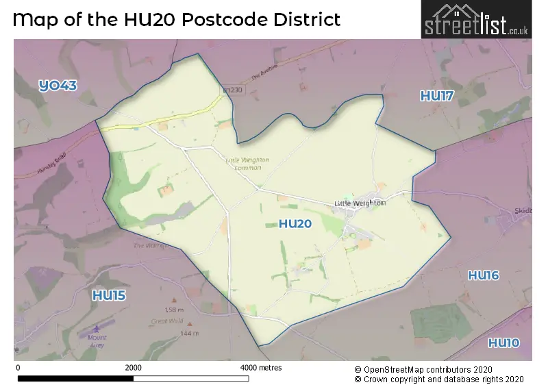
Map of the Postcode District
Explore the postcode district by using our interactive map.
Circles represent recorded crime; the larger the circle, the higher the crime rates.
Your support helps keep this site running!
If you enjoy using this website, consider buying me a coffee to help cover hosting costs.
The postcode district located in the HU Hull postal area , HU20 has a population of 881 residents according to the 2021 England and Wales Census.
The area of the district is 6.81 square miles (17.65 square kilometers or 4,360.95 acres).
Where is the HU20 District?
To give you an idea where the district is located we have created the following table showing nearby towns.
Nearest Towns to HU20
| Town | Distance (miles) | Direction |
|---|---|---|
| South Cave | 3.30 | WSW |
| Cottingham | 4.80 | E |
| Beverley | 5.31 | NE |
| Hessle | 6.14 | SE |
| Market Weighton | 7.59 | NW |
| Barton-upon-Humber | 8.31 | SSE |
| Kingston upon Hull | 8.72 | ESE |
| Winterton | 9.88 | SSW |
| Pocklington | 13.98 | NW |
| Hedon | 14.04 | ESE |
| Howden | 14.22 | WSW |
| Scunthorpe | 14.65 | SSW |
| Driffield | 15.22 | NNE |
| Goole | 15.27 | WSW |
| Brigg | 16.70 | S |
| Hornsea | 17.00 | ENE |
| Immingham | 17.88 | SE |
| Crowle | 17.89 | SW |
| Thorne | 21.67 | SW |
| Epworth | 21.98 | SSW |
The post town for this district is COTTINGHAM.
Postcode Information for District HU20 (Total Geographical Postcodes: 34)
| Location | Post Town | Sector | Number of Postcodes |
|---|---|---|---|
| Little Weighton | COTTINGHAM | HU20 3 | 28 |
| Rowley | COTTINGHAM | HU20 3 | 3 |
| Riplingham | COTTINGHAM | HU20 3 | 1 |
| Low Hunsley | COTTINGHAM | HU20 3 | 1 |
| High Hunsley | COTTINGHAM | HU20 3 | 1 |
The primary settlement in the HU20 postcode district is High Hunsley, located in the county of East Riding of Yorkshire in England. Other significant settlements in the district include Little Weighton, Low Hunsley, Riplingham, and Rowley. The post town associated with this district is Cottingham.
When it comes to local government, postal geography often disregards political borders. However, this district intersects the following councils: the district mostly encompasses the East Riding of Yorkshire area with a total of 34 postal codes.
The largest settlement in the HU20 postal code is Little Weighton followed by Rowley, and High Hunsley.
The HU20 Postcode shares a border with HU17 (BEVERLEY, Leven, Walkington) and YO43 (Market Weighton, Holme-on-Spalding-Moor, North Newbald).
Postcode Sectors


Schools in the Sector
Little Weighton Rowley Church of England Voluntary Controlled Primary School
Phase: Primary
Address: White Gap Road , Little Weighton , Cottingham
Postcode: HU20 3XE
Headteacher: Miss Susie Varley (Headteacher)
Ofsted Rating: Requires improvement
Stations in the Sector
No stations found in this postcode district.
Accessable Motorway Junctions
M62 J38
Average Driving Time from within the district: 12.95
Average Driving Distance: 8.36
Number of Postcodes that can access the Motorway Junction: 34
M62 J37
Average Driving Time from within the district: 21.02
Average Driving Distance: 16.57
Number of Postcodes that can access the Motorway Junction: 34
M62 J36
Average Driving Time from within the district: 23.44
Average Driving Distance: 19.04
Number of Postcodes that can access the Motorway Junction: 33
M180 J5
Average Driving Time from within the district: 23.89
Average Driving Distance: 17.85
Number of Postcodes that can access the Motorway Junction: 34
M180 J4
Average Driving Time from within the district: 30.05
Average Driving Distance: 24.23
Number of Postcodes that can access the Motorway Junction: 34
M180 J3
Average Driving Time from within the district: 37.14
Average Driving Distance: 32.99
Number of Postcodes that can access the Motorway Junction: 1
Weather Forecast for Cottingham
| Time Period | Icon | Description | Temperature | Rain Probability | Wind |
|---|---|---|---|---|---|
| 12:00 to 15:00 | Partly cloudy (day) | 14.0°C (feels like 12.0°C) | 1.00% | W 11 mph | |
| 15:00 to 18:00 | Sunny day | 14.0°C (feels like 13.0°C) | 0.00% | W 7 mph | |
| 18:00 to 21:00 | Clear night | 11.0°C (feels like 10.0°C) | 0.00% | WSW 4 mph | |
| 21:00 to 00:00 | Clear night | 9.0°C (feels like 7.0°C) | 0.00% | SW 4 mph |
| Time Period | Icon | Description | Temperature | Rain Probability | Wind |
|---|---|---|---|---|---|
| 00:00 to 03:00 | Clear night | 8.0°C (feels like 7.0°C) | 0.00% | SW 4 mph | |
| 03:00 to 06:00 | Clear night | 8.0°C (feels like 6.0°C) | 0.00% | SSW 7 mph | |
| 06:00 to 09:00 | Clear night | 8.0°C (feels like 6.0°C) | 0.00% | SSW 7 mph | |
| 09:00 to 12:00 | Overcast | 9.0°C (feels like 7.0°C) | 6.00% | SW 9 mph | |
| 12:00 to 15:00 | Overcast | 13.0°C (feels like 11.0°C) | 6.00% | SSW 11 mph | |
| 15:00 to 18:00 | Cloudy | 14.0°C (feels like 12.0°C) | 3.00% | SSW 9 mph | |
| 18:00 to 21:00 | Partly cloudy (night) | 12.0°C (feels like 10.0°C) | 1.00% | S 9 mph | |
| 21:00 to 00:00 | Cloudy | 11.0°C (feels like 9.0°C) | 3.00% | S 11 mph |
| Time Period | Icon | Description | Temperature | Rain Probability | Wind |
|---|---|---|---|---|---|
| 00:00 to 03:00 | Clear night | 11.0°C (feels like 8.0°C) | 1.00% | S 11 mph | |
| 03:00 to 06:00 | Partly cloudy (night) | 10.0°C (feels like 7.0°C) | 2.00% | S 11 mph | |
| 06:00 to 09:00 | Clear night | 9.0°C (feels like 7.0°C) | 1.00% | S 11 mph | |
| 09:00 to 12:00 | Sunny day | 11.0°C (feels like 8.0°C) | 1.00% | SSE 13 mph | |
| 12:00 to 15:00 | Partly cloudy (day) | 14.0°C (feels like 11.0°C) | 1.00% | S 16 mph | |
| 15:00 to 18:00 | Cloudy | 15.0°C (feels like 12.0°C) | 4.00% | S 13 mph | |
| 18:00 to 21:00 | Clear night | 13.0°C (feels like 11.0°C) | 1.00% | SSE 13 mph | |
| 21:00 to 00:00 | Partly cloudy (night) | 13.0°C (feels like 11.0°C) | 3.00% | SSE 13 mph |
| Time Period | Icon | Description | Temperature | Rain Probability | Wind |
|---|---|---|---|---|---|
| 00:00 to 03:00 | Cloudy | 13.0°C (feels like 10.0°C) | 15.00% | SSE 13 mph | |
| 03:00 to 06:00 | Cloudy | 13.0°C (feels like 11.0°C) | 17.00% | S 11 mph | |
| 06:00 to 09:00 | Cloudy | 12.0°C (feels like 10.0°C) | 14.00% | S 11 mph | |
| 09:00 to 12:00 | Partly cloudy (day) | 12.0°C (feels like 10.0°C) | 8.00% | S 11 mph | |
| 12:00 to 15:00 | Cloudy | 13.0°C (feels like 11.0°C) | 13.00% | SSW 13 mph | |
| 15:00 to 18:00 | Partly cloudy (day) | 13.0°C (feels like 11.0°C) | 12.00% | S 11 mph | |
| 18:00 to 21:00 | Clear night | 11.0°C (feels like 9.0°C) | 6.00% | S 9 mph | |
| 21:00 to 00:00 | Partly cloudy (night) | 10.0°C (feels like 7.0°C) | 3.00% | SSW 11 mph |
| Time Period | Icon | Description | Temperature | Rain Probability | Wind |
|---|---|---|---|---|---|
| 00:00 to 03:00 | Partly cloudy (night) | 9.0°C (feels like 6.0°C) | 6.00% | SSW 11 mph | |
| 03:00 to 06:00 | Clear night | 9.0°C (feels like 6.0°C) | 4.00% | SSW 11 mph | |
| 06:00 to 09:00 | Partly cloudy (night) | 8.0°C (feels like 5.0°C) | 6.00% | SSW 11 mph | |
| 09:00 to 12:00 | Partly cloudy (day) | 10.0°C (feels like 7.0°C) | 6.00% | SSW 13 mph | |
| 12:00 to 15:00 | Cloudy | 12.0°C (feels like 9.0°C) | 10.00% | SW 16 mph | |
| 15:00 to 18:00 | Cloudy | 12.0°C (feels like 10.0°C) | 11.00% | SW 13 mph | |
| 18:00 to 21:00 | Clear night | 11.0°C (feels like 8.0°C) | 7.00% | SW 13 mph | |
| 21:00 to 00:00 | Clear night | 10.0°C (feels like 7.0°C) | 4.00% | SW 11 mph |
| Postal Sector | Delivery Office |
|---|---|
| HU20 3 | Cottingham Delivery Office |
| H | U | 2 | 0 | - | X | X | X |
| H | U | 2 | 0 | Space | Numeric | Letter | Letter |
Street List for the HU20 District
Current Monthly Rental Prices
| # Bedrooms | Min Price | Max Price | Avg Price |
|---|---|---|---|
| 2 | £750 | £750 | £750 |
Current House Prices
| # Bedrooms | Min Price | Max Price | Avg Price |
|---|---|---|---|
| £795,000 | £795,000 | £795,000 | |
| 2 | £149,950 | £149,950 | £149,950 |
| 5 | £465,000 | £585,000 | £525,000 |
Estate Agents
| Logo | Name | Brand Name | Address | Contact Number |
|---|---|---|---|---|
 | Cottingham | Lovelle Estate Agency | Unit 4 King Street, Cottingham, HU16 5QQ | 01482 424960 |
 | Pocklington | R M English Yorkshire Limited | 2 Railway Street Pocklington York Yorkshire, YO42 2QZ | 01759 486194 |
 | London | OpenRent | 39 Great Windmill Street London W1D 7LX | 020 3322 3265 |
 | York | Churchills Estate Agents | 3a Bishopthorpe Road, York, YO23 1NA | 01904 935538 |
 | Brough | Matthew Limb Estate Agents Ltd | Unit 2 Welton Road Retail Park Brough, HU15 1AF | 01482 251747 |
Yearly House Price Averages for the District
| Type of Property | 2018 Average | 2018 Sales | 2017 Average | 2017 Sales | 2016 Average | 2016 Sales | 2015 Average | 2015 Sales |
|---|---|---|---|---|---|---|---|---|
| Detached | £350,318 | 11 | £329,444 | 9 | £255,864 | 11 | £345,500 | 5 |
| Semi-Detached | £170,600 | 5 | £195,167 | 6 | £151,750 | 4 | £181,114 | 7 |
| Terraced | £121,500 | 2 | £0 | 0 | £123,000 | 1 | £375,000 | 1 |
| Flats | £0 | 0 | £127,500 | 1 | £0 | 0 | £0 | 0 |