The HU8 9 postcode sector is within the county of East Riding of Yorkshire.
Did you know? According to the 2021 Census, the HU8 9 postcode sector is home to a bustling 15,242 residents!
Given that each sector allows for 400 unique postcode combinations. Letters C, I, K, M, O and V are not allowed in the last two letters of a postcode. With 295 postcodes already in use, this leaves 105 units available.
The HU8 9 postal code covers the settlement of HULL.
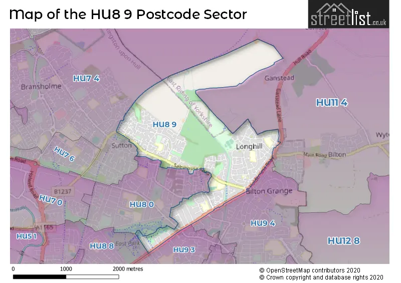
The HU8 9 Postcode shares a border with HU7 4 (Bransholme, Sutton-on-Hull, HULL), HU9 3 (HULL), HU9 4 (HULL), HU11 4 (Bilton, Aldbrough, Sproatley), HU8 0 (HULL) and HU8 8 (HULL, Garden Village).
The sector is within the post town of HULL.
HU8 9 is a postcode sector within the HU8 postcode district which is within the HU Hull postcode area.
The Royal Mail delivery office for the HU8 9 postal sector is the Hull City Delivery Office.
The area of the HU8 9 postcode sector is 2.03 square miles which is 5.25 square kilometres or 1,297.23 square acres.
Waterways within the HU8 9 postcode sector include the Holderness Drain.

Map of the HU8 9 Postcode Sector
Explore the HU8 9 postcode sector by using our free interactive map.
| H | U | 8 | - | 9 | X | X |
| H | U | 8 | Space | 9 | Letter | Letter |
Official List of Streets
HULL (172 Streets)
Unofficial Streets or Alternative Spellings
Bilton
GANSTEAD LANEHULL
BATTERSEA PARK BRENTFORD DRIVE CHARNOCK AVENUE FINCHLEY CLOSE HAYMARKET CLOSE MARFLEET LANE MIDDLESEX ROAD MITCHAM ROAD OAK CROFT PINDERFIELD CLOSE PORTOBELLO STREET SAVOY ROAD THE BROADWAYSwine
SWINE LANE ASPELL WALK BATTERSEA CLOSE BRIMHAM MEWS DARNHOLM COURT EAST MOUNT AVENUE HAWKESBURY STREET HOLMGARTH DRIVE HORNSEA RAIL TRAIL KILTON COURT LEALHOLM COURT LEALHOLME COURT NORTHERN CLOSE SHELVINGTON WALK ST BARTHOLEMEWS WAY ST BARTHOLOMEWS WAY ST JAMES CLOSE ST MARGARETS COURT ST. MICHAELS CLOSE SUTTON COURT TORRIDGE ROADSutton-on-Hull
CHURCH STREET FOXHOLME ROAD INGS ROADBransholme
KESTREL AVENUEWeather Forecast for HU8 9
Press Button to Show Forecast for Sutton-On-Hull
| Time Period | Icon | Description | Temperature | Rain Probability | Wind |
|---|---|---|---|---|---|
| 09:00 to 12:00 | Sunny day | 17.0°C (feels like 16.0°C) | 0.00% | E 9 mph | |
| 12:00 to 15:00 | Cloudy | 19.0°C (feels like 16.0°C) | 3.00% | ESE 11 mph | |
| 15:00 to 18:00 | Cloudy | 18.0°C (feels like 15.0°C) | 4.00% | ESE 13 mph | |
| 18:00 to 21:00 | Cloudy | 16.0°C (feels like 14.0°C) | 4.00% | ESE 11 mph | |
| 21:00 to 00:00 | Clear night | 13.0°C (feels like 12.0°C) | 1.00% | ESE 7 mph |
Press Button to Show Forecast for Sutton-On-Hull
| Time Period | Icon | Description | Temperature | Rain Probability | Wind |
|---|---|---|---|---|---|
| 00:00 to 03:00 | Clear night | 12.0°C (feels like 11.0°C) | 2.00% | E 4 mph | |
| 03:00 to 06:00 | Clear night | 11.0°C (feels like 10.0°C) | 2.00% | ENE 4 mph | |
| 06:00 to 09:00 | Sunny day | 13.0°C (feels like 12.0°C) | 1.00% | E 4 mph | |
| 09:00 to 12:00 | Partly cloudy (day) | 19.0°C (feels like 18.0°C) | 1.00% | SSE 7 mph | |
| 12:00 to 15:00 | Sunny day | 22.0°C (feels like 20.0°C) | 2.00% | SSE 11 mph | |
| 15:00 to 18:00 | Partly cloudy (day) | 22.0°C (feels like 20.0°C) | 4.00% | SSE 13 mph | |
| 18:00 to 21:00 | Cloudy | 19.0°C (feels like 17.0°C) | 7.00% | SE 11 mph | |
| 21:00 to 00:00 | Cloudy | 17.0°C (feels like 15.0°C) | 5.00% | SE 9 mph |
Press Button to Show Forecast for Sutton-On-Hull
| Time Period | Icon | Description | Temperature | Rain Probability | Wind |
|---|---|---|---|---|---|
| 00:00 to 03:00 | Cloudy | 15.0°C (feels like 13.0°C) | 6.00% | SE 9 mph | |
| 03:00 to 06:00 | Cloudy | 14.0°C (feels like 12.0°C) | 7.00% | SE 9 mph | |
| 06:00 to 09:00 | Cloudy | 14.0°C (feels like 13.0°C) | 11.00% | ESE 9 mph | |
| 09:00 to 12:00 | Cloudy | 16.0°C (feels like 14.0°C) | 20.00% | ESE 11 mph | |
| 12:00 to 15:00 | Light rain | 17.0°C (feels like 15.0°C) | 46.00% | ESE 13 mph | |
| 15:00 to 18:00 | Cloudy | 18.0°C (feels like 16.0°C) | 13.00% | SE 13 mph | |
| 18:00 to 21:00 | Cloudy | 17.0°C (feels like 16.0°C) | 15.00% | SSE 9 mph | |
| 21:00 to 00:00 | Cloudy | 15.0°C (feels like 14.0°C) | 12.00% | SE 7 mph |
Press Button to Show Forecast for Sutton-On-Hull
| Time Period | Icon | Description | Temperature | Rain Probability | Wind |
|---|---|---|---|---|---|
| 00:00 to 03:00 | Cloudy | 13.0°C (feels like 12.0°C) | 6.00% | SE 7 mph | |
| 03:00 to 06:00 | Cloudy | 12.0°C (feels like 11.0°C) | 6.00% | SE 7 mph | |
| 06:00 to 09:00 | Cloudy | 13.0°C (feels like 12.0°C) | 7.00% | ESE 7 mph | |
| 09:00 to 12:00 | Cloudy | 16.0°C (feels like 15.0°C) | 11.00% | ESE 7 mph | |
| 12:00 to 15:00 | Cloudy | 16.0°C (feels like 15.0°C) | 14.00% | ESE 9 mph | |
| 15:00 to 18:00 | Cloudy | 17.0°C (feels like 15.0°C) | 14.00% | E 9 mph | |
| 18:00 to 21:00 | Cloudy | 15.0°C (feels like 14.0°C) | 13.00% | ESE 7 mph | |
| 21:00 to 00:00 | Cloudy | 13.0°C (feels like 12.0°C) | 4.00% | E 4 mph |
Press Button to Show Forecast for Sutton-On-Hull
| Time Period | Icon | Description | Temperature | Rain Probability | Wind |
|---|---|---|---|---|---|
| 00:00 to 03:00 | Cloudy | 12.0°C (feels like 11.0°C) | 4.00% | E 4 mph | |
| 03:00 to 06:00 | Cloudy | 10.0°C (feels like 10.0°C) | 6.00% | E 4 mph | |
| 06:00 to 09:00 | Cloudy | 12.0°C (feels like 12.0°C) | 7.00% | SSW 4 mph | |
| 09:00 to 12:00 | Cloudy | 16.0°C (feels like 16.0°C) | 5.00% | SW 4 mph | |
| 12:00 to 15:00 | Cloudy | 18.0°C (feels like 17.0°C) | 8.00% | E 7 mph | |
| 15:00 to 18:00 | Cloudy | 17.0°C (feels like 16.0°C) | 12.00% | E 7 mph | |
| 18:00 to 21:00 | Cloudy | 15.0°C (feels like 14.0°C) | 11.00% | E 7 mph | |
| 21:00 to 00:00 | Cloudy | 13.0°C (feels like 12.0°C) | 8.00% | ENE 7 mph |
Schools and Places of Education Within the HU8 9 Postcode Sector
Bellfield Primary School
Academy converter
Saxby Road, Hull, , HU8 9DD
Head: Miss Anna Howard
Ofsted Rating: Good
Inspection: 2023-01-18 (480 days ago)
Website: Visit Bellfield Primary School Website
Phone: 01482374490
Number of Pupils: 246
Longhill Primary School
Academy converter
Shannon Road, Kingston-upon-Hull, , HU8 9RW
Head: Mark Batty
Ofsted Rating: Good
Inspection: 2021-11-25 (899 days ago)
Website: Visit Longhill Primary School Website
Phone: 01482814160
Number of Pupils: 383
Spring Cottage Primary School
Academy converter
Dressay Grove, Hull, , HU8 9JH
Head: Mr Andy Rhodes
Ofsted Rating: Outstanding
Inspection: 2023-11-30 (164 days ago)
Website: Visit Spring Cottage Primary School Website
Phone: 01482794183
Number of Pupils: 480
Wansbeck Primary School
Academy sponsor led
Wenning Grove, Hull, , HU8 9SR
Head: Mrs S Bullen
Ofsted Rating: Good
Inspection: 2019-06-11 (1797 days ago)
Website: Visit Wansbeck Primary School Website
Phone: 01482814171
Number of Pupils: 250
Wilberforce College
Further education
Saltshouse Road, Kingston-upon-Hull, , HU8 9HD
Head: Mr Colin Peaks
Ofsted Rating: Good
Inspection: 2018-02-07 (2286 days ago)
Website: Visit Wilberforce College Website
Phone: 01482711688
Number of Pupils: 0
House Prices in the HU8 9 Postcode Sector
| Type of Property | 2018 Average | 2018 Sales | 2017 Average | 2017 Sales | 2016 Average | 2016 Sales | 2015 Average | 2015 Sales |
|---|---|---|---|---|---|---|---|---|
| Detached | £196,007 | 34 | £192,085 | 27 | £196,662 | 47 | £176,594 | 34 |
| Semi-Detached | £127,520 | 83 | £122,486 | 81 | £113,020 | 75 | £111,765 | 101 |
| Terraced | £92,810 | 90 | £88,644 | 103 | £90,376 | 87 | £82,009 | 119 |
| Flats | £78,679 | 7 | £75,167 | 9 | £78,957 | 7 | £77,875 | 8 |
Important Postcodes HU8 9 in the Postcode Sector
HU8 9DD is the postcode for Bellfield Primary School, Saxby Road, and BELLFIELD PRIMARY SCHOOL, SAXBY ROAD, KINGSTON UPON HULL
HU8 9HD is the postcode for BLOCK Q, Wilberforce College, Saltshouse Road, BLOCK P, Wilberforce College, Saltshouse Road, BLOCK K, Wilberforce College, Saltshouse Road, BLOCK N, Wilberforce College, Saltshouse Road, BLOCK L, Wilberforce College, Saltshouse Road, BLOCK L/M, Wilberforce College, Saltshouse Road, BLOCK A/B/C, Wilberforce College, Saltshouse Road, BLOCK F, Wilberforce College, Saltshouse Road, BLOCK H, Wilberforce College, Saltshouse Road, BLOCK G, Wilberforce College, Saltshouse Road, BLOCK E, Wilberforce College, Saltshouse Road, BLOCK A/B/C/P, Wilberforce College, Saltshouse Road, BLOCK D WILBERFORCE COLLEGE, Wilberforce College, Saltshouse Road, and BLOCK J, Wilberforce College, Saltshouse Road
HU8 9HE is the postcode for Hull and East Yorkshire Hospitals NHS Trust, Princess Royal Hospital
HU8 9HJ is the postcode for Euler Academy, 262 Saltshouse Road
HU8 9HP is the postcode for Humberside Police, Tower Grange Police Station, Holderness Road
HU8 9HR is the postcode for 347, Saltshouse Road
HU8 9JH is the postcode for SINGLE STOREY BLOCK, Spring Cottage Primary School, Dressay Grove, 2-STOREY BLOCK, Spring Cottage Primary School, Dressay Grove, and Spring Cottage Primary School, Dressay Grove
HU8 9PD is the postcode for Kingston upon Hull City Council, 112 Shannon Road
HU8 9RW is the postcode for LONGHILL PRIMARY SCHOOL, SHANNON ROAD, KINGSTON UPON HULL, Longhill Primary School, Shannon Road, Longhill Health Centre, 162 Shannon Road, and Longhill Childrens Centre, 160 Shannon Road
HU8 9SR is the postcode for WANSBECK PRIMARY SCHOOL, WANSBECK ROAD, KINGSTON UPON HULL, and Wansbeck Primary School, Wenning Grove
| The HU8 9 Sector is within these Local Authorities |
|
|---|---|
| The HU8 9 Sector is within these Counties |
|
| The HU8 9 Sector is within these Water Company Areas |
|