The HX2 postcode district is a postal district located in the HX Halifax postcode area with a population of 37,097 residents according to the 2021 England and Wales Census.
The area of the HX2 postcode district is 16.67 square miles which is 43.17 square kilometres or 10,666.89 acres.
Currently, the HX2 district has about 1115 postcode units spread across 5 geographic postcode sectors.
Given that each sector allows for 400 unique postcode combinations, the district has a capacity of 2,000 postcodes. With 1115 postcodes already in use, this leaves 885 units available.
The largest settlement in the HX2 postal code is HALIFAX followed by Luddendenfoot, and Illingworth.
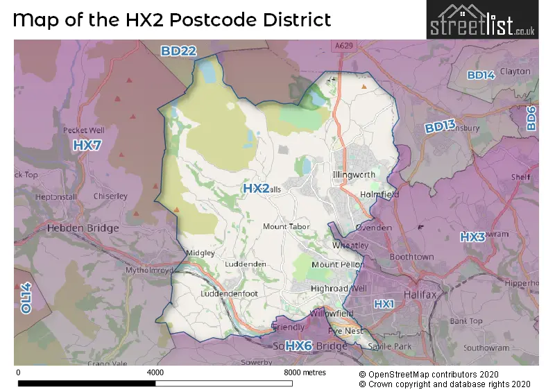
The HX2 Postcode shares a border with HX1 (HALIFAX), BD13 (Queensbury, Thornton, Denholme), HX3 (HALIFAX, Hipperholme, Northowram), HX6 (SOWERBY BRIDGE, Ripponden, Triangle), HX7 (HEBDEN BRIDGE, Mytholmroyd, Cragg Vale) and BD22 (KEIGHLEY, Oakworth, Oxenhope).
In the HX2 postcode district in West Yorkshire, the primary settlement is Halifax. Other significant settlements include Luddenden, Luddendenfoot, and Mount Tabor. The most significant Post Town in this district is Halifax, which is located in the county of West Yorkshire in England.
For the district HX2, we have data on 5 postcode sectors. Here's a breakdown: The sector HX2 0, covers Halifax in West Yorkshire. The sector HX2 6, covers Luddendenfoot and Luddenden in West Yorkshire. The sector HX2 7, covers Halifax in West Yorkshire. The sector HX2 8, covers Halifax in West Yorkshire. The sector HX2 9, covers Halifax in West Yorkshire.

Map of the HX2 Postcode District
Explore the HX2 postcode district by using our free interactive map.
When it comes to local government, postal geography often disregards political borders. However, for a breakdown in the HX2 District: the district mostly encompasses the Calderdale District (B) area with a total of 1122 postcodes.
Recent House Sales in HX2
| Date | Price | Address |
|---|---|---|
| 23/10/2023 | £185,000 | Gleanings Avenue, Halifax, HX2 0NX |
| 06/10/2023 | £155,000 | Crag Lane, Halifax, HX2 8UB |
| 29/09/2023 | £125,000 | Keighley Road, Halifax, HX2 8XB |
| 22/09/2023 | £310,000 | Ovenden Wood Road, Halifax, HX2 0TQ |
| 18/09/2023 | £72,000 | Albert Drive, Halifax, HX2 0HU |
| 14/09/2023 | £63,000 | Weatherhouse Terrace, Halifax, HX2 0PZ |
| 14/09/2023 | £63,000 | Ashville Gardens, Halifax, HX2 0PW |
| 11/09/2023 | £145,000 | Pye Nest Gardens, Halifax, HX2 7JU |
| 08/09/2023 | £128,500 | Langdale Crescent, Halifax, HX2 0XA |
| 07/09/2023 | £186,000 | Ovenden Wood, Halifax, HX2 0TN |
Weather Forecast for HX2
Press Button to Show Forecast for Illingworth
| Time Period | Icon | Description | Temperature | Rain Probability | Wind |
|---|---|---|---|---|---|
| 06:00 to 09:00 | Cloudy | 2.0°C (feels like 0.0°C) | 4.00% | NE 7 mph | |
| 09:00 to 12:00 | Cloudy | 6.0°C (feels like 3.0°C) | 6.00% | ENE 9 mph | |
| 12:00 to 15:00 | Overcast | 7.0°C (feels like 5.0°C) | 49.00% | ENE 9 mph | |
| 15:00 to 18:00 | Light rain | 7.0°C (feels like 4.0°C) | 53.00% | ENE 9 mph | |
| 18:00 to 21:00 | Light rain | 6.0°C (feels like 3.0°C) | 54.00% | ENE 9 mph | |
| 21:00 to 00:00 | Cloudy | 4.0°C (feels like 2.0°C) | 7.00% | NE 9 mph |
Press Button to Show Forecast for Illingworth
| Time Period | Icon | Description | Temperature | Rain Probability | Wind |
|---|---|---|---|---|---|
| 00:00 to 03:00 | Cloudy | 3.0°C (feels like 0.0°C) | 4.00% | NE 7 mph | |
| 03:00 to 06:00 | Cloudy | 3.0°C (feels like 0.0°C) | 7.00% | NNE 9 mph | |
| 06:00 to 09:00 | Light rain | 4.0°C (feels like 1.0°C) | 42.00% | NNE 9 mph | |
| 09:00 to 12:00 | Light rain | 6.0°C (feels like 3.0°C) | 47.00% | N 9 mph | |
| 12:00 to 15:00 | Light rain | 7.0°C (feels like 5.0°C) | 49.00% | NW 9 mph | |
| 15:00 to 18:00 | Light rain | 9.0°C (feels like 6.0°C) | 45.00% | WNW 11 mph | |
| 18:00 to 21:00 | Sunny day | 8.0°C (feels like 5.0°C) | 8.00% | W 9 mph | |
| 21:00 to 00:00 | Clear night | 4.0°C (feels like 2.0°C) | 1.00% | WSW 7 mph |
Press Button to Show Forecast for Illingworth
| Time Period | Icon | Description | Temperature | Rain Probability | Wind |
|---|---|---|---|---|---|
| 00:00 to 03:00 | Partly cloudy (night) | 4.0°C (feels like 1.0°C) | 2.00% | SW 7 mph | |
| 03:00 to 06:00 | Clear night | 3.0°C (feels like 0.0°C) | 2.00% | SSW 7 mph | |
| 06:00 to 09:00 | Partly cloudy (day) | 5.0°C (feels like 2.0°C) | 3.00% | S 7 mph | |
| 09:00 to 12:00 | Partly cloudy (day) | 9.0°C (feels like 6.0°C) | 3.00% | S 11 mph | |
| 12:00 to 15:00 | Cloudy | 11.0°C (feels like 8.0°C) | 7.00% | S 13 mph | |
| 15:00 to 18:00 | Cloudy | 11.0°C (feels like 9.0°C) | 9.00% | S 13 mph | |
| 18:00 to 21:00 | Cloudy | 11.0°C (feels like 9.0°C) | 11.00% | S 11 mph | |
| 21:00 to 00:00 | Partly cloudy (night) | 8.0°C (feels like 6.0°C) | 5.00% | SSE 9 mph |
Press Button to Show Forecast for Illingworth
| Time Period | Icon | Description | Temperature | Rain Probability | Wind |
|---|---|---|---|---|---|
| 00:00 to 03:00 | Clear night | 7.0°C (feels like 4.0°C) | 4.00% | SE 7 mph | |
| 03:00 to 06:00 | Clear night | 6.0°C (feels like 3.0°C) | 3.00% | ESE 7 mph | |
| 06:00 to 09:00 | Partly cloudy (day) | 6.0°C (feels like 4.0°C) | 5.00% | ESE 7 mph | |
| 09:00 to 12:00 | Partly cloudy (day) | 10.0°C (feels like 7.0°C) | 5.00% | ESE 11 mph | |
| 12:00 to 15:00 | Cloudy | 13.0°C (feels like 10.0°C) | 9.00% | ESE 13 mph | |
| 15:00 to 18:00 | Cloudy | 14.0°C (feels like 11.0°C) | 12.00% | ESE 11 mph | |
| 18:00 to 21:00 | Partly cloudy (day) | 12.0°C (feels like 10.0°C) | 7.00% | ESE 11 mph | |
| 21:00 to 00:00 | Cloudy | 10.0°C (feels like 8.0°C) | 8.00% | E 9 mph |
Where is the HX2 Postcode District?
The postcode district HX2 is located in HALIFAX, a town in West Yorkshire. It is near several other towns, including HEBDEN BRIDGE to the West (4.11 miles away), SOWERBY BRIDGE to the South (5.21 miles away), ELLAND to the South East (5.59 miles away), BRADFORD to the East (8.28 miles away), KEIGHLEY to the North (8.29 miles away), and BINGLEY to the North East (8.41 miles away). Additionally, HALIFAX is approximately 172.32 miles away from the center of London.
The district is within the post town of HALIFAX.
The sector has postcodes within the nation of England.
The HX2 Postcode District is in the Calderdale and Kirklees region of West Yorkshire within the Yorkshire and The Humber.
| Postcode Sector | Delivery Office |
|---|---|
| HX2 0 | Halifax Delivery Office |
| HX2 6 | Halifax Delivery Office |
| HX2 7 | Halifax Delivery Office |
| HX2 8 | Halifax Delivery Office |
| HX2 9 | Halifax Delivery Office |
| H | X | 2 | - | X | X | X |
| H | X | 2 | Space | Numeric | Letter | Letter |
Tourist Attractions within the Postcode Area
We found 1 visitor attractions within the HX2 postcode area
| Ogden Water Country Park |
|---|
| Wildlife |
| Nature Reserve / Wetlands / Wildlife Trips |
| View Ogden Water Country Park on Google Maps |
Current Monthly Rental Prices
| # Bedrooms | Min Price | Max Price | Avg Price |
|---|---|---|---|
| £395 | £395 | £395 | |
| 1 | £511 | £511 | £511 |
| 2 | £498 | £1,200 | £728 |
| 3 | £900 | £950 | £917 |
Current House Prices
| # Bedrooms | Min Price | Max Price | Avg Price |
|---|---|---|---|
| £59,950 | £275,000 | £120,790 | |
| 1 | £76,000 | £150,000 | £121,833 |
| 2 | £39,995 | £375,000 | £155,901 |
| 3 | £80,000 | £595,000 | £229,166 |
| 4 | £89,950 | £1,500,000 | £419,239 |
| 5 | £289,950 | £900,000 | £604,992 |
| 6 | £550,000 | £795,000 | £672,500 |
Estate Agents who Operate in the HX2 District
| Logo | Name | Brand Name | Address | Contact Number | Total Properties |
|---|---|---|---|---|---|
 | Halifax | William H. Brown | 6 Bull Green, Halifax, Yorkshire, HX1 5AB | 01422 413767 | 20 |
 | Halifax | Ryder & Dutton | 8 Silver Street, Halifax, HX1 1HS | 01422 412577 | 18 |
 | Sowerby Bridge | William H. Brown | 14 Wharf Street, Sowerby Bridge, HX6 2AE | 01422 412857 | 12 |
 | Halifax | Bridgfords | 12 Bull Green, Halifax, HX1 5AB | 01422 412950 | 10 |
 | Covering Yorkshire | EweMove | Cavendish House Littlewood Drive, Cleckheaton, BD19 4TE | 03304 700193 | 10 |
| Type of Property | 2018 Average | 2018 Sales | 2017 Average | 2017 Sales | 2016 Average | 2016 Sales | 2015 Average | 2015 Sales |
|---|---|---|---|---|---|---|---|---|
| Detached | £263,474 | 51 | £267,950 | 64 | £278,840 | 73 | £263,976 | 76 |
| Semi-Detached | £149,634 | 241 | £145,816 | 224 | £145,397 | 233 | £143,126 | 216 |
| Terraced | £107,779 | 264 | £109,236 | 283 | £107,772 | 254 | £108,995 | 247 |
| Flats | £158,050 | 20 | £111,264 | 36 | £118,444 | 28 | £69,098 | 62 |