
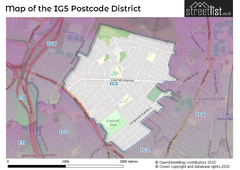
Map of the Postcode District
Explore the postcode district by using our interactive map.
Circles represent recorded crime; the larger the circle, the higher the crime rates.
Your support helps keep this site running!
If you enjoy using this website, consider buying me a coffee to help cover hosting costs.
The postcode district located in the IG Ilford postal area , IG5 has a population of 18,328 residents according to the 2021 England and Wales Census.
The area of the district is 1.02 square miles (2.63 square kilometers or 650.52 acres).
Where is the IG5 District?
To give you an idea where the district is located we have created the following table showing nearby towns.
Nearest Towns to IG5
| Town | Distance (miles) | Direction |
|---|---|---|
| Chigwell | 2.05 | NNE |
| Loughton | 4.49 | N |
| Waltham Abbey | 6.87 | NNW |
| Epping | 7.69 | NNE |
| Waltham Cross | 7.73 | NNW |
| City of London | 8.52 | SW |
| Cheshunt | 8.94 | NNW |
| City of Westminster | 10.24 | SW |
| Brentwood | 10.68 | ENE |
| Chipping Ongar | 11.09 | NE |
| Hoddesdon | 12.00 | NNW |
| Dartford | 12.26 | SE |
| Harlow | 12.36 | N |
| Potters Bar | 13.15 | WNW |
| Swanscombe | 13.52 | SE |
| Grays | 13.75 | SE |
| Swanley | 14.20 | SSE |
| Borehamwood | 15.05 | WNW |
| Billericay | 15.42 | E |
| Hertford | 15.44 | NNW |
The post town for this district is ILFORD.
Postcode Information for District IG5 (Total Geographical Postcodes: 240)
| Location | Post Town | Sector | Number of Postcodes |
|---|---|---|---|
| ILFORD | ILFORD | IG5 0 | 240 |
Retail and Shopping in IG5
Street
Town
Locality
Number of Shops
Central Postcode
View on Google Maps
LONGWOOD GARDENS
ILFORD
19
IG5 0EW
View on Google Maps
CLAYBURY BROADWAY
ILFORD
15
IG5 0LQ
View on Google Maps
CLAYHALL AVENUE
ILFORD
8
IG5 0NY
View on Google Maps
ATHERTON ROAD
ILFORD
6
IG5 0PQ
View on Google Maps
FULLWELL AVENUE
ILFORD
6
IG5 0RF
View on Google Maps
| Street | Town | Locality | Number of Shops | Central Postcode | View on Google Maps |
|---|---|---|---|---|---|
| LONGWOOD GARDENS | ILFORD | 19 | IG5 0EW | View on Google Maps | |
| CLAYBURY BROADWAY | ILFORD | 15 | IG5 0LQ | View on Google Maps | |
| CLAYHALL AVENUE | ILFORD | 8 | IG5 0NY | View on Google Maps | |
| ATHERTON ROAD | ILFORD | 6 | IG5 0PQ | View on Google Maps | |
| FULLWELL AVENUE | ILFORD | 6 | IG5 0RF | View on Google Maps |
In the IG5 postcode district, the primary settlement is Ilford, located in the county of Greater London. There are no other significant settlements mentioned in the data. The post town for this district is also Ilford.
When it comes to local government, postal geography often disregards political borders. However, this district intersects the following councils: the district mostly encompasses the Redbridge London Boro area with a total of 234 postal codes.
The largest settlements in the IG5 postal code are CLAYHALL and ILFORD.
The IG5 Postcode shares a border with IG4 (ILFORD), IG6 (HAINAULT, BARKINGSIDE, ILFORD) and IG8 (WOODFORD GREEN).
Postcode Sectors


Schools in the Sector
Parkhill Infants' School
Phase: Primary
Address: Lord Avenue , Clayhall , Ilford
Postcode: IG5 0DB
Headteacher: Mrs Rebecca Teague (Headteacher)
Ofsted Rating: Good
Parkhill Junior School
Phase: Primary
Address: Lord Avenue , Clayhall , Ig13se , Ilford
Postcode: IG5 0DB
Headteacher: Mrs Denise Hughes-Mulhall (Headteacher)
Ofsted Rating: Good
Stradbroke
Phase: Not applicable
Address: 133 Stradbroke Grove , Ilford
Postcode: IG5 0DL
Headteacher: Ms Mandy Quinn ()
Ofsted Rating: Good
Glade Primary School
Phase: Primary
Address: Atherton Road , Clayhall , Ilford
Postcode: IG5 0PF
Headteacher: Mrs Farzana Hussain (Headteacher)
Ofsted Rating: Good
Caterham High School
Phase: Secondary
Address: Caterham Avenue , Clayhall , Ilford
Postcode: IG5 0QW
Headteacher: Ms Belinda Chapple (Headteacher)
Ofsted Rating: Good
Gilbert Colvin Primary School
Phase: Primary
Address: Strafford Avenue , Ilford
Postcode: IG5 0TL
Headteacher: Ms Liz Cohen (Headteacher)
Ofsted Rating: Good
Stations in the Sector
No stations found in this postcode district.
Accessable Motorway Junctions
M11 J5
Average Driving Time from within the district: 8.89
Average Driving Distance: 4.57
Number of Postcodes that can access the Motorway Junction: 234
M25 J27
Average Driving Time from within the district: 13.05
Average Driving Distance: 10.30
Number of Postcodes that can access the Motorway Junction: 234
M11 J6
Average Driving Time from within the district: 13.34
Average Driving Distance: 10.59
Number of Postcodes that can access the Motorway Junction: 232
M25 J28
Average Driving Time from within the district: 15.56
Average Driving Distance: 10.08
Number of Postcodes that can access the Motorway Junction: 2
M25 J26
Average Driving Time from within the district: 16.02
Average Driving Distance: 9.68
Number of Postcodes that can access the Motorway Junction: 234
Weather Forecast for Ilford
| Time Period | Icon | Description | Temperature | Rain Probability | Wind |
|---|---|---|---|---|---|
| 12:00 to 15:00 | Partly cloudy (day) | 15.0°C (feels like 13.0°C) | 40.00% | WSW 11 mph | |
| 15:00 to 18:00 | Cloudy | 16.0°C (feels like 15.0°C) | 5.00% | WSW 7 mph | |
| 18:00 to 21:00 | Clear night | 14.0°C (feels like 14.0°C) | 7.00% | SW 4 mph | |
| 21:00 to 00:00 | Clear night | 13.0°C (feels like 12.0°C) | 0.00% | SW 4 mph |
| Time Period | Icon | Description | Temperature | Rain Probability | Wind |
|---|---|---|---|---|---|
| 00:00 to 03:00 | Partly cloudy (night) | 11.0°C (feels like 11.0°C) | 1.00% | SW 4 mph | |
| 03:00 to 06:00 | Partly cloudy (night) | 10.0°C (feels like 10.0°C) | 4.00% | SW 2 mph | |
| 06:00 to 09:00 | Fog | 10.0°C (feels like 10.0°C) | 14.00% | S 2 mph | |
| 09:00 to 12:00 | Fog | 11.0°C (feels like 11.0°C) | 12.00% | SSE 4 mph | |
| 12:00 to 15:00 | Partly cloudy (day) | 15.0°C (feels like 15.0°C) | 1.00% | S 4 mph | |
| 15:00 to 18:00 | Cloudy | 16.0°C (feels like 15.0°C) | 18.00% | S 7 mph | |
| 18:00 to 21:00 | Clear night | 13.0°C (feels like 12.0°C) | 0.00% | SSE 4 mph | |
| 21:00 to 00:00 | Clear night | 11.0°C (feels like 10.0°C) | 0.00% | SE 4 mph |
| Time Period | Icon | Description | Temperature | Rain Probability | Wind |
|---|---|---|---|---|---|
| 00:00 to 03:00 | Clear night | 11.0°C (feels like 10.0°C) | 0.00% | SE 7 mph | |
| 03:00 to 06:00 | Clear night | 10.0°C (feels like 9.0°C) | 1.00% | SE 7 mph | |
| 06:00 to 09:00 | Clear night | 10.0°C (feels like 9.0°C) | 0.00% | SE 7 mph | |
| 09:00 to 12:00 | Sunny day | 13.0°C (feels like 11.0°C) | 1.00% | SSE 9 mph | |
| 12:00 to 15:00 | Partly cloudy (day) | 16.0°C (feels like 14.0°C) | 1.00% | S 11 mph | |
| 15:00 to 18:00 | Sunny day | 17.0°C (feels like 15.0°C) | 2.00% | S 11 mph | |
| 18:00 to 21:00 | Clear night | 15.0°C (feels like 13.0°C) | 2.00% | SSE 9 mph | |
| 21:00 to 00:00 | Clear night | 15.0°C (feels like 13.0°C) | 6.00% | SSE 11 mph |
| Time Period | Icon | Description | Temperature | Rain Probability | Wind |
|---|---|---|---|---|---|
| 00:00 to 03:00 | Clear night | 15.0°C (feels like 13.0°C) | 17.00% | S 11 mph | |
| 03:00 to 06:00 | Light rain | 14.0°C (feels like 12.0°C) | 46.00% | SSW 11 mph | |
| 06:00 to 09:00 | Cloudy | 12.0°C (feels like 11.0°C) | 13.00% | SSW 7 mph | |
| 09:00 to 12:00 | Partly cloudy (day) | 13.0°C (feels like 11.0°C) | 7.00% | SSW 9 mph | |
| 12:00 to 15:00 | Partly cloudy (day) | 14.0°C (feels like 12.0°C) | 10.00% | SW 11 mph | |
| 15:00 to 18:00 | Partly cloudy (day) | 14.0°C (feels like 11.0°C) | 9.00% | SW 11 mph | |
| 18:00 to 21:00 | Clear night | 12.0°C (feels like 10.0°C) | 6.00% | SW 11 mph | |
| 21:00 to 00:00 | Clear night | 10.0°C (feels like 8.0°C) | 1.00% | SW 9 mph |
| Time Period | Icon | Description | Temperature | Rain Probability | Wind |
|---|---|---|---|---|---|
| 00:00 to 03:00 | Clear night | 9.0°C (feels like 7.0°C) | 1.00% | SW 9 mph | |
| 03:00 to 06:00 | Clear night | 9.0°C (feels like 7.0°C) | 1.00% | SW 9 mph | |
| 06:00 to 09:00 | Clear night | 9.0°C (feels like 7.0°C) | 3.00% | SW 9 mph | |
| 09:00 to 12:00 | Sunny day | 11.0°C (feels like 8.0°C) | 6.00% | SW 11 mph | |
| 12:00 to 15:00 | Partly cloudy (day) | 13.0°C (feels like 11.0°C) | 8.00% | SW 13 mph | |
| 15:00 to 18:00 | Cloudy | 13.0°C (feels like 11.0°C) | 13.00% | SW 11 mph | |
| 18:00 to 21:00 | Clear night | 12.0°C (feels like 10.0°C) | 10.00% | SW 11 mph | |
| 21:00 to 00:00 | Clear night | 11.0°C (feels like 9.0°C) | 6.00% | SW 11 mph |
| Postal Sector | Delivery Office |
|---|---|
| IG5 0 | Ilford Delivery Office |
| I | G | 5 | - | X | X | X |
| I | G | 5 | Space | Numeric | Letter | Letter |
Street List for the IG5 District
Current Monthly Rental Prices
| # Bedrooms | Min Price | Max Price | Avg Price |
|---|---|---|---|
| £953 | £953 | £953 | |
| 1 | £700 | £700 | £700 |
| 2 | £1,800 | £1,800 | £1,800 |
| 3 | £2,400 | £2,400 | £2,400 |
| 4 | £2,400 | £2,400 | £2,400 |
| 5 | £3,200 | £3,200 | £3,200 |
Current House Prices
| # Bedrooms | Min Price | Max Price | Avg Price |
|---|---|---|---|
| 1 | £120,000 | £280,000 | £170,874 |
| 2 | £265,000 | £525,000 | £359,412 |
| 3 | £300,000 | £700,000 | £527,857 |
| 4 | £500,000 | £950,000 | £696,111 |
| 5 | £700,000 | £950,000 | £800,833 |
| 6 | £800,000 | £950,000 | £875,000 |
Estate Agents
| Logo | Name | Brand Name | Address | Contact Number |
|---|---|---|---|---|
 | Barkingside | Bairstow Eves | 31 High Street, Barkingside, Ilford, Essex, IG6 2AD | 020 3869 5975 |
 | Barkingside | haart | 54 High Street, Barkingside, Ilford, IG6 2DQ | 020 3834 7952 |
 | Barkingside | Douglas Allen | 59b High Street Barkingside Ilford IG6 2AD | 020 3873 1509 |
 | Redbridge | Sandra Davidson Estate Agents | 10 Roding Lane South, Redbridge IG4 5NX | 020 3909 9755 |
 | Ilford | Sovereign House Estates | 176 Longwood Gardens, Clayhall, Ilford, Essex, IG5 0EW | 020 8220 1500 |
Yearly House Price Averages for the District
| Type of Property | 2018 Average | 2018 Sales | 2017 Average | 2017 Sales | 2016 Average | 2016 Sales | 2015 Average | 2015 Sales |
|---|---|---|---|---|---|---|---|---|
| Detached | £636,500 | 6 | £516,607 | 14 | £562,313 | 8 | £460,175 | 20 |
| Semi-Detached | £529,580 | 64 | £505,114 | 67 | £490,281 | 79 | £448,625 | 80 |
| Terraced | £479,771 | 74 | £478,080 | 56 | £449,671 | 55 | £414,790 | 50 |
| Flats | £272,071 | 35 | £266,107 | 28 | £252,558 | 30 | £217,419 | 47 |