The IV10 postcode district is a postal district located in the IV Inverness postcode area with a population of 2,501 residents according to the 2011 Scotland Census.
The area of the IV10 postcode district is 14.29 square miles which is 37.01 square kilometres or 9,145.87 acres.
Currently, the IV10 district has about 81 postcode units spread across 1 geographic postcode sectors.
Given that each sector allows for 400 unique postcode combinations, the district has a capacity of 400 postcodes. With 81 postcodes already in use, this leaves 319 units available.
The largest settlements in the IV10 postal code are FORTROSE and Rosemarkie.
The postcode area has a boundary with The Moray Firth.
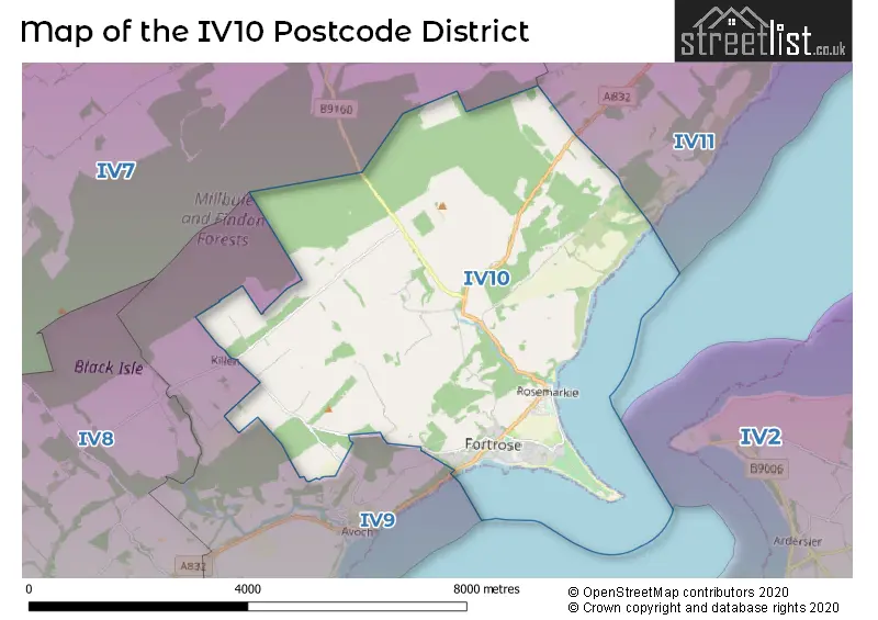
The IV10 Postcode shares a border with IV7 (Conon Bridge, Culbokie, Maryburgh) and IV9 (AVOCH, Killen, Rosehaugh).
The primary settlement in the IV10 postcode district is Fortrose, located in the county of Ross and Cromarty. Other significant settlements in the district include Rosemarkie. The most significant postal town in the district is Fortrose.
For the district IV10, we have data on 1 postcode sectors. Here's a breakdown: The sector IV10 8, covers Fortrose and Rosemarkie in Ross and Cromarty.
IV10 Postcode Sectors

Map of the IV10 Postcode District
Explore the IV10 postcode district by using our free interactive map.
When it comes to local government, postal geography often disregards political borders. However, for a breakdown in the IV10 District: the district mostly encompasses the Highland area with a total of 85 postcodes.
Weather Forecast for IV10
Press Button to Show Forecast for Rosemarkie North (Beach)
| Time Period | Icon | Description | Temperature | Rain Probability | Wind |
|---|---|---|---|---|---|
| 00:00 to 03:00 | Cloudy | 4.0°C (feels like 3.0°C) | 5.00% | W 2 mph | |
| 03:00 to 06:00 | Mist | 3.0°C (feels like 2.0°C) | 12.00% | WSW 4 mph | |
| 06:00 to 09:00 | Cloudy | 4.0°C (feels like 3.0°C) | 3.00% | SW 4 mph | |
| 09:00 to 12:00 | Cloudy | 7.0°C (feels like 6.0°C) | 6.00% | SSE 2 mph | |
| 12:00 to 15:00 | Light rain | 8.0°C (feels like 6.0°C) | 50.00% | ESE 7 mph | |
| 15:00 to 18:00 | Light rain shower (day) | 8.0°C (feels like 6.0°C) | 40.00% | E 9 mph | |
| 18:00 to 21:00 | Light rain shower (day) | 7.0°C (feels like 6.0°C) | 43.00% | SSE 7 mph | |
| 21:00 to 00:00 | Light rain | 6.0°C (feels like 4.0°C) | 47.00% | SSW 7 mph |
Press Button to Show Forecast for Rosemarkie North (Beach)
| Time Period | Icon | Description | Temperature | Rain Probability | Wind |
|---|---|---|---|---|---|
| 00:00 to 03:00 | Cloudy | 5.0°C (feels like 3.0°C) | 5.00% | SSE 4 mph | |
| 03:00 to 06:00 | Clear night | 3.0°C (feels like 2.0°C) | 2.00% | W 2 mph | |
| 06:00 to 09:00 | Partly cloudy (day) | 5.0°C (feels like 4.0°C) | 3.00% | N 4 mph | |
| 09:00 to 12:00 | Partly cloudy (day) | 7.0°C (feels like 6.0°C) | 5.00% | ENE 4 mph | |
| 12:00 to 15:00 | Cloudy | 9.0°C (feels like 7.0°C) | 9.00% | NE 9 mph | |
| 15:00 to 18:00 | Cloudy | 9.0°C (feels like 7.0°C) | 11.00% | NE 9 mph | |
| 18:00 to 21:00 | Partly cloudy (day) | 9.0°C (feels like 7.0°C) | 5.00% | NNE 7 mph | |
| 21:00 to 00:00 | Cloudy | 6.0°C (feels like 5.0°C) | 5.00% | WNW 4 mph |
Press Button to Show Forecast for Rosemarkie North (Beach)
| Time Period | Icon | Description | Temperature | Rain Probability | Wind |
|---|---|---|---|---|---|
| 00:00 to 03:00 | Clear night | 5.0°C (feels like 3.0°C) | 2.00% | SW 4 mph | |
| 03:00 to 06:00 | Partly cloudy (night) | 4.0°C (feels like 2.0°C) | 2.00% | SSW 7 mph | |
| 06:00 to 09:00 | Partly cloudy (day) | 5.0°C (feels like 4.0°C) | 3.00% | SSW 4 mph | |
| 09:00 to 12:00 | Partly cloudy (day) | 9.0°C (feels like 8.0°C) | 4.00% | SSE 7 mph | |
| 12:00 to 15:00 | Cloudy | 11.0°C (feels like 9.0°C) | 12.00% | SE 9 mph | |
| 15:00 to 18:00 | Cloudy | 12.0°C (feels like 9.0°C) | 14.00% | ESE 11 mph | |
| 18:00 to 21:00 | Cloudy | 12.0°C (feels like 10.0°C) | 13.00% | SSE 9 mph | |
| 21:00 to 00:00 | Cloudy | 9.0°C (feels like 7.0°C) | 5.00% | SE 9 mph |
Press Button to Show Forecast for Rosemarkie North (Beach)
| Time Period | Icon | Description | Temperature | Rain Probability | Wind |
|---|---|---|---|---|---|
| 00:00 to 03:00 | Partly cloudy (night) | 8.0°C (feels like 6.0°C) | 2.00% | ESE 7 mph | |
| 03:00 to 06:00 | Partly cloudy (night) | 7.0°C (feels like 5.0°C) | 3.00% | ESE 7 mph | |
| 06:00 to 09:00 | Cloudy | 9.0°C (feels like 7.0°C) | 6.00% | E 7 mph | |
| 09:00 to 12:00 | Partly cloudy (day) | 11.0°C (feels like 10.0°C) | 2.00% | ESE 9 mph | |
| 12:00 to 15:00 | Partly cloudy (day) | 13.0°C (feels like 11.0°C) | 8.00% | ESE 11 mph | |
| 15:00 to 18:00 | Cloudy | 14.0°C (feels like 11.0°C) | 16.00% | E 13 mph | |
| 18:00 to 21:00 | Cloudy | 12.0°C (feels like 10.0°C) | 7.00% | E 11 mph | |
| 21:00 to 00:00 | Partly cloudy (night) | 9.0°C (feels like 7.0°C) | 4.00% | ENE 9 mph |
Where is the IV10 Postcode District?
The postcode district IV10 is located in the town of Fortrose in the United Kingdom. Fortrose is surrounded by several nearby towns, including Avoch to the South West, Cromarty to the North East, Invergordon to the North, Edinburgh to the South, Dingwall to the West, Alness to the North West, and Nairn to the South East. Additionally, Fortrose is approximately 451.47 miles away from the center of London.
The district is within the post town of FORTROSE.
The sector has postcodes within the nation of Scotland.
The IV10 Postcode District is covers the following regions.
- Caithness & Sutherland and Ross & Cromarty - Highlands and Islands - Scotland
- Inverness & Nairn and Moray, Badenoch & Strathspey - Highlands and Islands - Scotland
- Lochaber, Skye & Lochalsh, Arran & Cumbrae and Argyll & Bute - Highlands and Islands - Scotland
Postcode Sectors within the IV10 District
| Postcode Sector | Delivery Office |
|---|---|
| IV10 8 | Fortrose Scale Payment Delivery Office |
| I | V | 1 | 0 | - | X | X | X |
| I | V | 1 | 0 | Space | Numeric | Letter | Letter |
Current Monthly Rental Prices
| # Bedrooms | Min Price | Max Price | Avg Price |
|---|
Current House Prices
| # Bedrooms | Min Price | Max Price | Avg Price |
|---|---|---|---|
| £85,000 | £985,000 | £281,000 | |
| 2 | £135,000 | £194,000 | £165,083 |
| 3 | £170,000 | £330,000 | £270,000 |
| 4 | £310,000 | £450,000 | £358,333 |
| 5 | £500,000 | £500,000 | £500,000 |
Estate Agents who Operate in the IV10 District
| Logo | Name | Brand Name | Address | Contact Number | Total Properties |
|---|---|---|---|---|---|
 | Inverness | Strutt & Parker | Perth Suite Castle House Fairways Business Park Inverness IV2 6AA | 01463 217916 | 6 |
 | Inverness | Macleod & MacCallum | 28 Queensgate Inverness, IV1 1DJ | 01463 217902 | 3 |
 | Covering Nationwide | The Agency UK | Covering Nationwide | 020 3909 1509 | 3 |
 | Inverness | Hamish Homes Ltd | Beechwood House Beechwood Park, Inverness, IV2 3BW | 01463 217924 | 3 |
 | Scotland | Yopa | Meridian House Wheatfield Way Hinckley LE10 1YG | 0161 524 0574 | 2 |