The LN11 0 postcode sector is within the county of Lincolnshire.
Did you know? According to the 2021 Census, the LN11 0 postcode sector is home to a bustling 10,461 residents!
Given that each sector allows for 400 unique postcode combinations. Letters C, I, K, M, O and V are not allowed in the last two letters of a postcode. With 344 postcodes already in use, this leaves 56 units available.
The largest settlement in the LN11 0 postal code is LOUTH followed by Fulstow, and Fotherby.
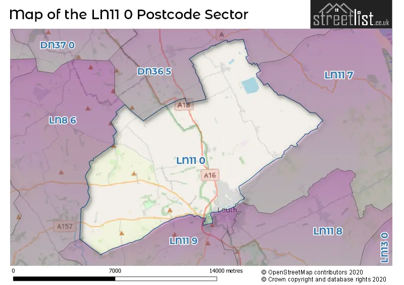
The LN11 0 Postcode shares a border with DN36 5 (Holton-le-Clay, Tetney, North Thoresby), LN8 6 (Binbrook, Ludford, Benniworth), LN11 7 (North Somercotes, Saltfleet, LOUTH), LN11 8 (LOUTH, Manby, Grimoldby) and LN11 9 (LOUTH, Donington-on-Bain, Scamblesby).
The sector is within the post town of LOUTH.
LN11 0 is a postcode sector within the LN1 postcode district which is within the LN Lincoln postcode area.
The Royal Mail delivery office for the LN11 0 postal sector is the unknown.
The area of the LN11 0 postcode sector is 46.45 square miles which is 120.30 square kilometres or 29,727.51 square acres.

Map of the LN11 0 Postcode Sector
Explore the LN11 0 postcode sector by using our free interactive map.
| L | N | 1 | 1 | - | 0 | X | X |
| L | N | 1 | 1 | Space | 0 | Letter | Letter |
Official List of Streets
LOUTH (152 Streets)
Fairfield Industrial Estate (8 Streets)
Fotherby (12 Streets)
Grainthorpe (1 Streets)
Utterby (7 Streets)
Covenham St. Bartholomew (3 Streets)
North Ormsby (1 Streets)
Fulstow (15 Streets)
Alvingham (6 Streets)
North Elkington (1 Streets)
South Elkington (4 Streets)
Covenham St. Mary (4 Streets)
Yarburgh (1 Streets)
Welton Le Wold (1 Streets)
Calcethorpe (1 Streets)
Unofficial Streets or Alternative Spellings
Conisholme
FEN LANE ABBEY ROAD ACTHORPE LANE ACTHORPE TOP ALVINGHAM ROAD BARTON STREET BENNETT ROAD BINBROOK LANE BINBROOK ROAD BUNKERS HILL LANE CALBOM COURT CARLBOM COURT CASTLE WAY CROSSCLIFF HILL DARK LANE ELKINGTON ROUNDABOUT ENGINE GATE WALK ENGINE LANE ESPIN WALK EYRE CRESCENT FAIRFIELD ROUNDABOUT FUSION WAY HALF ACRE HOLY WELL LANE HURTONS LANE LAND DIKE LOCKING GARTH LOUTH BYPASS LUDFORD ROAD MAGNA CARTA MEWS MILFORD COURT POKE HOLES LANE SALTERS LANE TERENCE COURT THE CRESCENT THE MOORINGS TREASURE LANE WESTFIELD ROAD WESTGATE PLACEAlvingham
LOCK ROADLudborough
LIVESEY ROADLOUTH
CANNON STREET COMMERCIAL ROAD NICHOL HILL WESTGATESouth Ormsby
BLUESTONE HEATH ROADAshby-cum-Fenby
BARTON STREETBinbrook
BLANDS HILLBurgh-on-Bain
MAIN ROADGrainthorpe
FEN LANEHolton-le-Clay
LOUTH ROADSchools and Places of Education Within the LN11 0 Postcode Sector
Greenwich House School
Other independent school
106 High Holme Road, Louth, Lincolnshire, LN11 0HE
Head: Mrs Arran Brindle
Ofsted Rating: Good
Inspection: 2019-03-21 (1890 days ago)
Website: Visit Greenwich House School Website
Phone: 01507609252
Number of Pupils: 96
The Utterby Primary Academy
Academy converter
Utterby, Louth, Lincolnshire, LN11 0TN
Head: Mr Tom Hawkins
Ofsted Rating: Good
Inspection: 2021-11-30 (905 days ago)
Website: Visit The Utterby Primary Academy Website
Phone: 01472840280
Number of Pupils: 67
House Prices in the LN11 0 Postcode Sector
| Type of Property | 2018 Average | 2018 Sales | 2017 Average | 2017 Sales | 2016 Average | 2016 Sales | 2015 Average | 2015 Sales |
|---|---|---|---|---|---|---|---|---|
| Detached | £257,222 | 76 | £258,380 | 87 | £218,413 | 61 | £238,179 | 61 |
| Semi-Detached | £162,402 | 45 | £150,388 | 50 | £137,901 | 47 | £143,118 | 34 |
| Terraced | £129,935 | 62 | £132,043 | 68 | £128,612 | 54 | £117,264 | 70 |
| Flats | £100,800 | 10 | £112,667 | 3 | £86,100 | 5 | £85,100 | 5 |
Important Postcodes LN11 0 in the Postcode Sector
LN11 0BX is the postcode for The Pilgrim School, Victoria Road
LN11 0EU is the postcode for Louth Site, Block 43, High Holme Road, Louth Site, Block 44, High Holme Road, BLOCK 14, Louth County Hospital, High Holme Road, Louth Site, Block 27, High Holme Road, BLOCK 21, Louth County Hospital, High Holme Road, BLOCK 8, Louth County Hospital, High Holme Road, Louth County Hospital, High Holme Road, Louth Site, Block 8, High Holme Road, BLOCK 6, Louth County Hospital, High Holme Road, Louth Site, Block 23, High Holme Road, United Lincolnshire Hospitals NHS Trust, Louth County Hospital, Louth Site, Block 45, High Holme Road, and LOUTH SITE BLOCK 27, Louth County Hospital, High Holme Road
LN11 0HG is the postcode for Louth Lower Academy, North Holme Road, and SIXTH FORM, Louth Lower Academy, North Holme Road
LN11 0JN is the postcode for The James Street Family Practice, 49 James Street
LN11 0LF is the postcode for East Midlands Ambulance Service NHS Trust, Ambulance Station, Windsor Road
LN11 0LL is the postcode for H M Revenue & Customs, Revenue Buildings, Chequergate
LN11 0LS is the postcode for East Lindsey District Council, Fairfield Enterprise Centre
LN11 0LY is the postcode for Lincolnshire County Council, Louth Library, Northgate, and Louth Library, Northgate
LN11 0TN is the postcode for Utterby Cp School, Utterby
LN11 0XL is the postcode for Fulstow Cp School, Churchthorpe
LN11 0YB is the postcode for Translinc Service Centre, Warwick Road
| The LN11 0 Sector is within these Local Authorities |
|
|---|---|
| The LN11 0 Sector is within these Counties |
|
| The LN11 0 Sector is within these Water Company Areas |
|
Tourist Attractions within the LN11 0 Postcode Area
We found 1 visitor attractions within the LN1 postcode area
| Louth Museum |
|---|
| Museums & Art Galleries |
| Museum and / or Art Gallery |
| View Louth Museum on Google Maps |