The LN13 postcode district is a postal district located in the LN Lincoln postcode area with a population of 8,222 residents according to the 2021 England and Wales Census.
The area of the LN13 postcode district is 64.41 square miles which is 166.83 square kilometres or 41,223.46 acres.
Currently, the LN13 district has about 334 postcode units spread across 2 geographic postcode sectors.
Given that each sector allows for 400 unique postcode combinations, the district has a capacity of 800 postcodes. With 334 postcodes already in use, this leaves 466 units available.
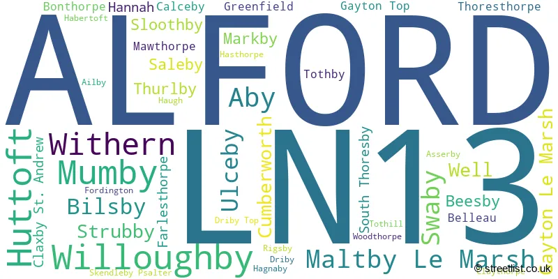
The largest settlement in the LN13 postal code is ALFORD followed by Huttoft, and Mumby.
The postcode area has a boundary with The North Sea.
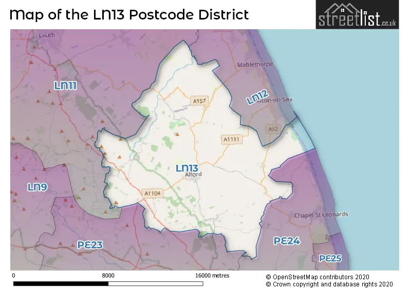
The LN13 Postcode shares a border with PE23 (SPILSBY, Hundleby, Halton Holegate), PE24 (Chapel St. Leonards, Burgh Le Marsh, Wainfleet), LN12 (MABLETHORPE, Sutton-on-Sea, Trusthorpe) and LN11 (LOUTH, North Somercotes, Saltfleet).
The primary settlement in the LN13 postcode district is Alford, located in the county of Lincolnshire in England. Other significant settlements include Aby, Beesby, Belleau, Calceby, Claxby St. Andrew, Claythorpe, Driby, Driby Top, Fordington, Gayton Le Marsh, Gayton Top, Greenfield, Haugh, Maltby Le Marsh, Rigsby, Saleby, Skendleby Psalter, South Thoresby, Strubby, Swaby, Thoresthorpe, Tothby, Tothill, Ulceby, Well, Withern, and Woodthorpe. The most significant post town in the district is Alford.
For the district LN13, we have data on 3 postcode sectors. Here's a breakdown: The sector LN13 0, covers Alford and Withern in Lincolnshire. The sector LN13 3 is non-geographic. It's often designated for PO Boxes, large organisations, or special services. The sector LN13 9, covers Alford in Lincolnshire.

Map of the LN13 Postcode District
Explore the LN13 postcode district by using our free interactive map.
When it comes to local government, postal geography often disregards political borders. However, for a breakdown in the LN13 District: the district mostly encompasses the East Lindsey District area with a total of 337 postcodes.
Recent House Sales in LN13
| Date | Price | Address |
|---|---|---|
| 29/09/2023 | £200,000 | Chapel Street, Alford, LN13 9DP |
| 08/09/2023 | £158,000 | Hamilton Road, Alford, LN13 9HD |
| 25/08/2023 | £282,500 | Millers Way, Alford, LN13 9EU |
| 21/08/2023 | £155,000 | Tothby Lane, Alford, LN13 0EE |
| 18/08/2023 | £150,000 | Candlehouse Lane, Alford, LN13 9EX |
| 09/08/2023 | £450,000 | Bilsby Road, Alford, LN13 9EW |
| 28/07/2023 | £249,950 | Hanby Lane, Willoughby, Alford, LN13 9NJ |
| 19/07/2023 | £195,000 | Main Road, Withern, Alford, LN13 0NB |
| 18/07/2023 | £215,000 | Main Street, Gayton Le Marsh, Alford, LN13 0NS |
| 14/07/2023 | £107,500 | Caroline Street, Alford, LN13 9BW |
Weather Forecast for LN13
Press Button to Show Forecast for Alford (Lincolnshire)
| Time Period | Icon | Description | Temperature | Rain Probability | Wind |
|---|---|---|---|---|---|
| 00:00 to 03:00 | Partly cloudy (night) | 3.0°C (feels like 0.0°C) | 1.00% | NW 7 mph | |
| 03:00 to 06:00 | Cloudy | 2.0°C (feels like 0.0°C) | 8.00% | NW 7 mph | |
| 06:00 to 09:00 | Partly cloudy (day) | 4.0°C (feels like 2.0°C) | 3.00% | NNW 7 mph | |
| 09:00 to 12:00 | Cloudy | 7.0°C (feels like 5.0°C) | 10.00% | NE 7 mph | |
| 12:00 to 15:00 | Overcast | 8.0°C (feels like 5.0°C) | 9.00% | NE 9 mph | |
| 15:00 to 18:00 | Cloudy | 8.0°C (feels like 6.0°C) | 5.00% | ENE 9 mph | |
| 18:00 to 21:00 | Partly cloudy (day) | 8.0°C (feels like 5.0°C) | 2.00% | E 9 mph | |
| 21:00 to 00:00 | Cloudy | 6.0°C (feels like 3.0°C) | 7.00% | E 7 mph |
Press Button to Show Forecast for Alford (Lincolnshire)
| Time Period | Icon | Description | Temperature | Rain Probability | Wind |
|---|---|---|---|---|---|
| 00:00 to 03:00 | Partly cloudy (night) | 5.0°C (feels like 3.0°C) | 5.00% | E 7 mph | |
| 03:00 to 06:00 | Cloudy | 5.0°C (feels like 2.0°C) | 9.00% | ENE 9 mph | |
| 06:00 to 09:00 | Cloudy | 7.0°C (feels like 4.0°C) | 9.00% | ENE 9 mph | |
| 09:00 to 12:00 | Cloudy | 8.0°C (feels like 5.0°C) | 14.00% | E 11 mph | |
| 12:00 to 15:00 | Cloudy | 9.0°C (feels like 7.0°C) | 14.00% | ENE 13 mph | |
| 15:00 to 18:00 | Cloudy | 9.0°C (feels like 6.0°C) | 11.00% | ENE 13 mph | |
| 18:00 to 21:00 | Cloudy | 9.0°C (feels like 6.0°C) | 9.00% | ENE 13 mph | |
| 21:00 to 00:00 | Cloudy | 8.0°C (feels like 5.0°C) | 15.00% | ENE 13 mph |
Press Button to Show Forecast for Alford (Lincolnshire)
| Time Period | Icon | Description | Temperature | Rain Probability | Wind |
|---|---|---|---|---|---|
| 00:00 to 03:00 | Overcast | 8.0°C (feels like 5.0°C) | 22.00% | NE 16 mph | |
| 03:00 to 06:00 | Light rain | 9.0°C (feels like 5.0°C) | 54.00% | NE 16 mph | |
| 06:00 to 09:00 | Heavy rain | 9.0°C (feels like 6.0°C) | 73.00% | ENE 13 mph | |
| 09:00 to 12:00 | Light rain | 11.0°C (feels like 9.0°C) | 57.00% | ESE 11 mph | |
| 12:00 to 15:00 | Light rain shower (day) | 11.0°C (feels like 9.0°C) | 43.00% | ESE 11 mph | |
| 15:00 to 18:00 | Heavy rain shower (day) | 10.0°C (feels like 7.0°C) | 60.00% | E 16 mph | |
| 18:00 to 21:00 | Light rain shower (day) | 10.0°C (feels like 7.0°C) | 37.00% | E 13 mph | |
| 21:00 to 00:00 | Cloudy | 8.0°C (feels like 6.0°C) | 10.00% | S 9 mph |
Where is the LN13 Postcode District?
The postcode district LN13 is located in Alford, a district town. Alford is nearby several other towns in different directions. To the north-east, there is Mablethorpe, which is approximately 5.5 miles away. To the south-west, there is Spilsby, which is approximately 7.8 miles away. To the north-west, there is Louth, which is approximately 9.8 miles away. To the south-east, there is Skegness, which is approximately 10.2 miles away. Alford is also about 13.1 miles west of Horncastle and 22.1 miles south of Boston. Additionally, the distance from Alford to the center of London is approximately 122.6 miles.
The district is within the post town of ALFORD.
The sector has postcodes within the nation of England.
The LN13 Postcode District is in the Lincolnshire region of Lincolnshire within the East Midlands (England).
| Postcode Sector | Delivery Office |
|---|---|
| LN13 0 | Alford (ln) Delivery Office |
| LN13 3 | Alford (ln) Delivery Office |
| LN13 9 | Alford (ln) Delivery Office |
| L | N | 1 | 3 | - | X | X | X |
| L | N | 1 | 3 | Space | Numeric | Letter | Letter |
Tourist Attractions within the Postcode Area
We found 1 visitor attractions within the LN13 postcode area
| Alford Five Sailed Windmill & Tea Room |
|---|
| Historic Properties |
| Other Historic Property |
| View Alford Five Sailed Windmill & Tea Room on Google Maps |
Current Monthly Rental Prices
| # Bedrooms | Min Price | Max Price | Avg Price |
|---|---|---|---|
| 1 | £410 | £410 | £410 |
| 2 | £525 | £595 | £560 |
| 4 | £1,500 | £1,500 | £1,500 |
Current House Prices
| # Bedrooms | Min Price | Max Price | Avg Price |
|---|---|---|---|
| £85,000 | £675,000 | £312,500 | |
| 1 | £95,000 | £110,000 | £102,500 |
| 2 | £40,000 | £315,000 | £159,473 |
| 3 | £35,995 | £995,000 | £212,992 |
| 4 | £195,000 | £850,000 | £413,840 |
| 5 | £265,000 | £1,850,000 | £634,167 |
| 14 | £1,500,000 | £1,500,000 | £1,500,000 |
Estate Agents who Operate in the LN13 District
| Logo | Name | Brand Name | Address | Contact Number | Total Properties |
|---|---|---|---|---|---|
 | Alford | Choice Properties | 16 South Market Place, Alford, LN13 9AE | 01507 307641 | 76 |
 | Mablethorpe | Choice Properties | 21 Victoria Road, Mablethorpe, LN12 2AF | 01507 307623 | 46 |
 | Alford | Willsons | 124 West Street, Alford, Lincolnshire, LN13 9DR | 01507 307806 | 19 |
 | Mablethorpe | Lovelle | 41 Victoria Road, Mablethorpe, LN12 2AF | 01507 308552 | 14 |
 | Sutton-on-Sea | Choice Properties | 34 High Street, Sutton-On-Sea, LN12 2HB | 01507 308556 | 6 |
- Aby
- Alford
- Anderby Creek
- Anderby
- Beesby
- Bilsby
- Bonthorpe
- Brinkhill
- Chapel St Leonards
- Claxby St Andrew
- Cumberworth
- Gayton le Marsh
- Hannah
- Helsey
- Hogsthorpe
- Huttoft
- Maltby le Marsh
- Markby
- Mawthorpe
- Mumby
- Saleby
- Sandilands
- Skendleby
- Sloothby
- South Reston
- South Thoresby
- Strubby
- Sutton on Sea
- Swaby
- Thurlby
- Tothby
- Ulceby
- Ulceby Cross
- White Pit
- Willoughby
- Withern
| Type of Property | 2018 Average | 2018 Sales | 2017 Average | 2017 Sales | 2016 Average | 2016 Sales | 2015 Average | 2015 Sales |
|---|---|---|---|---|---|---|---|---|
| Detached | £243,143 | 94 | £199,181 | 112 | £192,315 | 115 | £188,358 | 90 |
| Semi-Detached | £139,576 | 31 | £150,656 | 40 | £126,917 | 42 | £125,881 | 35 |
| Terraced | £99,800 | 19 | £108,705 | 21 | £100,595 | 22 | £67,575 | 12 |
| Flats | £95,000 | 1 | £56,000 | 1 | £101,975 | 2 | £94,950 | 1 |