The LS16 9 postcode sector is within the county of West Yorkshire.
Did you know? According to the 2021 Census, the LS16 9 postcode sector is home to a bustling 3,930 residents!
Given that each sector allows for 400 unique postcode combinations. Letters C, I, K, M, O and V are not allowed in the last two letters of a postcode. With 124 postcodes already in use, this leaves 276 units available.
The LS16 9 postal code covers the settlement of Bramhope.
The LS16 9 Postcode shares a border with LS16 7 (LEEDS, Cookridge), LS18 5 (Horsforth), LS21 1 (OTLEY, Pool In Wharfedale, Arthington), LS21 3 (OTLEY, Pool In Wharfedale), LS16 8 (LEEDS, Adel, Eccup) and LS19 7 (Yeadon, Rawdon).
The sector is within the post town of LEEDS.
LS16 9 is a postcode sector within the LS1 postcode district which is within the LS Leeds postcode area.
The Royal Mail delivery office for the LS16 9 postal sector is the unknown.
The area of the LS16 9 postcode sector is 2.84 square miles which is 7.36 square kilometres or 1,818.93 square acres.

Map of the LS16 9 Postcode Sector
Explore the LS16 9 postcode sector by using our free interactive map.
| L | S | 1 | 6 | - | 9 | X | X |
| L | S | 1 | 6 | Space | 9 | Letter | Letter |
Official List of Streets
Bramhope (87 Streets)
LEEDS (2 Streets)
Unofficial Streets or Alternative Spellings
Pool In Wharfedale
OLD POOL BANK POOL BANK NEW ROADHeadingley
OTLEY ROADLEEDS
COOKRIDGE LANEArthington
CRESKELD LANEHorsforth
OTLEY OLD ROAD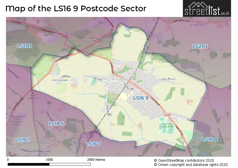
House Prices in the LS16 9 Postcode Sector
| Type of Property | 2018 Average | 2018 Sales | 2017 Average | 2017 Sales | 2016 Average | 2016 Sales | 2015 Average | 2015 Sales |
|---|---|---|---|---|---|---|---|---|
| Detached | £560,810 | 34 | £560,739 | 54 | £555,846 | 39 | £498,409 | 38 |
| Semi-Detached | £322,269 | 24 | £373,818 | 28 | £301,300 | 15 | £297,370 | 28 |
| Terraced | £301,333 | 3 | £403,688 | 8 | £316,600 | 5 | £0 | 0 |
| Flats | £241,143 | 7 | £250,704 | 12 | £240,938 | 8 | £230,244 | 8 |
Important Postcodes LS16 9 in the Postcode Sector
LS16 9BR is the postcode for UPPER SCHOOL, Bramhope Primary School, Tredgold Crescent, LOWER SCHOOL, Bramhope Primary School, Tredgold Crescent, and Bramhope Primary School, Tredgold Crescent
| The LS16 9 Sector is within these Local Authorities |
|
|---|---|
| The LS16 9 Sector is within these Counties |
|
| The LS16 9 Sector is within these Water Company Areas |
|