The LS11 0 postcode sector is within the county of West Yorkshire.
Did you know? According to the 2021 Census, the LS11 0 postcode sector is home to a bustling 4,410 residents!
Given that each sector allows for 400 unique postcode combinations. Letters C, I, K, M, O and V are not allowed in the last two letters of a postcode. With 103 postcodes already in use, this leaves 297 units available.
The LS11 0 postal code covers the settlement of LEEDS.
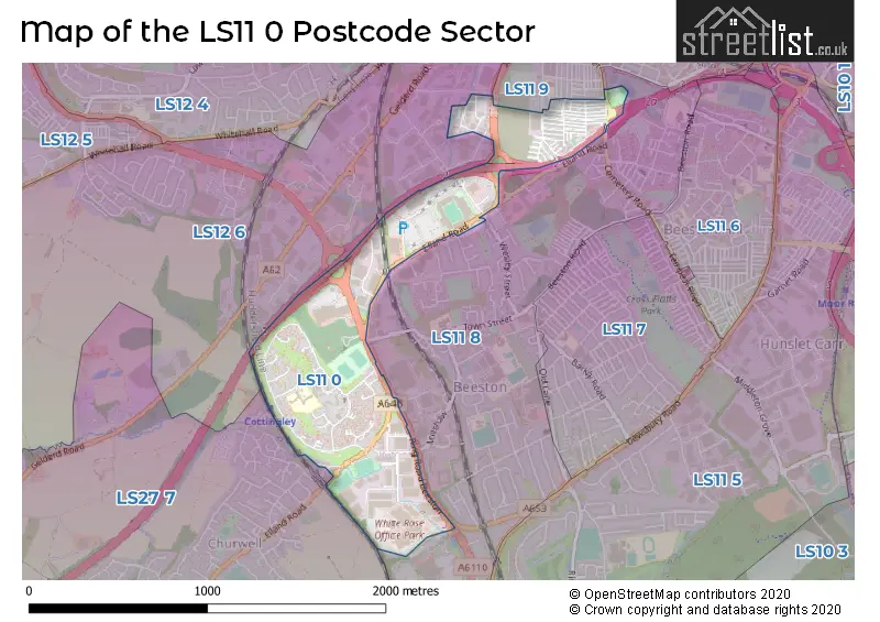
The LS11 0 Postcode shares a border with LS11 9 (LEEDS), LS12 6 (LEEDS, Lower Wortley, New Farnley), LS11 8 (LEEDS, Beeston) and LS27 7 (Morley).
The sector is within the post town of LEEDS.
LS11 0 is a postcode sector within the LS11 postcode district which is within the LS Leeds postcode area.
The Royal Mail delivery office for the LS11 0 postal sector is the Holbeck Delivery Office.
The area of the LS11 0 postcode sector is 0.55 square miles which is 1.42 square kilometres or 350.06 square acres.
The LS11 0 postcode sector is crossed by the M621 motorway.

Map of the LS11 0 Postcode Sector
Explore the LS11 0 postcode sector by using our free interactive map.
| L | S | 1 | 1 | - | 0 | X | X |
| L | S | 1 | 1 | Space | 0 | Letter | Letter |
Official List of Streets
LEEDS (70 Streets)
Unofficial Streets or Alternative Spellings
LEEDS
CROSBY ROAD FAIR VIEW HEATH GROVE INGRAM ROAD LOWFIELDS ROAD MANOR MILL LANE RUNSWICK STREET RYDALL STREET SHAFTON VIEW WESLEY STREET BACK COLENSO MOUNT BACK COLENSO ROAD BEESTON INTERCHANGE CROSBY AVENUE ELLAND ROAD INTERCHANGE HOXTON MOUNT INGRAM DISTRIBUTOR LOW FIELDS AVENUE RING ROAD BEESTON TILBURY ROWBeeston
CEMETERY ROADMorley
ELLAND ROAD OLD ROADSchools and Places of Education Within the LS11 0 Postcode Sector
Cottingley Primary Academy
Academy sponsor led
Dulverton Grove, Leeds, , LS11 0HU
Head: Kelly Bentley
Ofsted Rating: Good
Inspection: 2019-02-28 (1884 days ago)
Website: Visit Cottingley Primary Academy Website
Phone: 01132709503
Number of Pupils: 298
Elliott Hudson College
Free schools 16 to 19
The White Rose Office Park, Millshaw Park Lane, Leeds, West Yorkshire, LS11 0LT
Head: Mr Lee Styles
Ofsted Rating: Outstanding
Inspection: 2018-03-09 (2240 days ago)
Website: Visit Elliott Hudson College Website
Phone: 01133239777
Number of Pupils: 1061
House Prices in the LS11 0 Postcode Sector
| Type of Property | 2018 Average | 2018 Sales | 2017 Average | 2017 Sales | 2016 Average | 2016 Sales | 2015 Average | 2015 Sales |
|---|---|---|---|---|---|---|---|---|
| Detached | £0 | 0 | £0 | 0 | £0 | 0 | £130,000 | 1 |
| Semi-Detached | £101,375 | 8 | £125,333 | 3 | £99,071 | 7 | £92,500 | 2 |
| Terraced | £74,579 | 38 | £65,982 | 60 | £67,429 | 36 | £58,609 | 32 |
| Flats | £0 | 0 | £0 | 0 | £0 | 0 | £39,000 | 2 |
Important Postcodes LS11 0 in the Postcode Sector
LS11 0DL is the postcode for Elliott Hudson College, White Rose Office Park, Millshaw Park Lane, and Elliott Hudson College, White Rose Office Park
LS11 0EA is the postcode for H M Revenue & Customs, 1 Munroe Court White Rose Office Park, Millshaw Park Lane
LS11 0EU is the postcode for CEMETERY AND CREMATORIUM, COTTINGLEY HALL, RING ROAD BEESTON
LS11 0HP is the postcode for Adult Residential Centre, Cottingley Court
LS11 0HQ is the postcode for Springfield Nursery, Cottingley Approach
LS11 0HU is the postcode for Cottingley Primary School, Dulverton Grove
| The LS11 0 Sector is within these Local Authorities |
|
|---|---|
| The LS11 0 Sector is within these Counties |
|
| The LS11 0 Sector is within these Water Company Areas |
|