The LS11 5 postcode sector is within the county of West Yorkshire.
Did you know? According to the 2021 Census, the LS11 5 postcode sector is home to a bustling 5,550 residents!
Given that each sector allows for 400 unique postcode combinations. Letters C, I, K, M, O and V are not allowed in the last two letters of a postcode. With 198 postcodes already in use, this leaves 202 units available.
The largest settlements in the LS11 5 postal code are LEEDS and Holbeck.
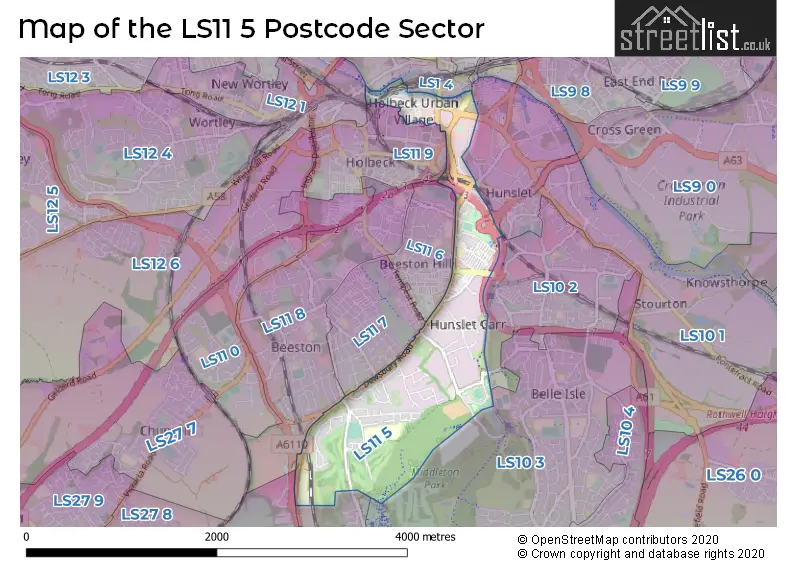
The LS11 5 Postcode shares a border with LS10 4 (LEEDS, Middleton), LS11 9 (LEEDS), LS27 8 (Morley), LS11 6 (LEEDS), LS11 7 (LEEDS, Beeston), LS11 8 (LEEDS, Beeston), LS1 4 (LEEDS), LS12 1 (LEEDS, Armley), LS10 1 (LEEDS, Hunslet), LS10 2 (LEEDS, Hunslet) and LS10 3 (LEEDS, Middleton).
The sector is within the post town of LEEDS.
LS11 5 is a postcode sector within the LS11 postcode district which is within the LS Leeds postcode area.
The Royal Mail delivery office for the LS11 5 postal sector is the Holbeck Delivery Office.
The area of the LS11 5 postcode sector is 1.31 square miles which is 3.40 square kilometres or 839.01 square acres.
The LS11 5 postcode sector is crossed by the M621 motorway.
Waterways within the LS11 5 postcode sector include the Leeds & Liverpool Canal, River Aire, Hol Beck.

Map of the LS11 5 Postcode Sector
Explore the LS11 5 postcode sector by using our free interactive map.
| L | S | 1 | 1 | - | 5 | X | X |
| L | S | 1 | 1 | Space | 5 | Letter | Letter |
Official List of Streets
LEEDS (104 Streets)
Unofficial Streets or Alternative Spellings
LEEDS
APEX VIEW CITY WALK COLWYN ROAD CROSS FLATTS AVENUE CROSS FLATTS GROVE CROSSLAND TERRACE GROVEHALL DRIVE HUNSLET HALL ROAD JUNCTION STREET KIDACRE STREET LINDEN GROVE LINDEN ROAD MAFEKING AVENUE MAFEKING GROVE MAFEKING MOUNT MANOR ROAD MARSHALL STREET MEADOW ROAD MIDDLETON CRESCENT MILLSHAW ROAD NEVILLE STREET OAKHURST AVENUE OLD LANE PARKSIDE MOUNT STRATFORD STREET TEMPEST ROAD TRENTHAM STREET WAINCLIFFE DRIVE WHARF APPROACH WOODVIEW GROVE WOODVIEW PLACE AIRE VALLEY TOWPATH ALPHA STREET FOOTBRIDGE BACK BURTON TERRACE BACK LINDEN GROVE BACK LONGROYD TERRACE BACK MAFEKING AVENUE BACK OAKLEY TERRACE BACK STRATFORD STREET BARKLY PARADE BEARING AVENUE CROSS LINDEN TERRACE DAVID OLUWALE BRIDGE ENVOY STREET FRONT ROW FRONT STREET GARNET VIEW JOHN CHARLES APPROACH MARCH STREET MONK BRIDGE MOORSIDE MALTINGS PARK WOOD AVENUE PARK WOOD CRESCENT PARK WOOD DRIVE PARK WOOD ROAD PARKWOOD CLOSE POULTON PLACE RING ROAD BEESTON SALEM PLACE ST DAVIDS COURT ST FRANCIS PLACE STONE ROW VICTORIA BRIDGE WHITEHALL BRIDGEBeeston
BARKLY ROADMiddleton
RING ROAD BEESTON PARKMorley
DEWSBURY ROADDrighlington
WHITEHALL ROADWeather Forecast for LS11 5
Press Button to Show Forecast for Hunslet Carr
| Time Period | Icon | Description | Temperature | Rain Probability | Wind |
|---|---|---|---|---|---|
| 00:00 to 03:00 | Cloudy | 14.0°C (feels like 14.0°C) | 33.00% | E 4 mph | |
| 03:00 to 06:00 | Partly cloudy (night) | 13.0°C (feels like 13.0°C) | 2.00% | ENE 4 mph | |
| 06:00 to 09:00 | Cloudy | 13.0°C (feels like 13.0°C) | 5.00% | E 4 mph | |
| 09:00 to 12:00 | Partly cloudy (day) | 17.0°C (feels like 16.0°C) | 3.00% | SE 7 mph | |
| 12:00 to 15:00 | Partly cloudy (day) | 21.0°C (feels like 18.0°C) | 1.00% | SSE 11 mph | |
| 15:00 to 18:00 | Cloudy | 21.0°C (feels like 18.0°C) | 4.00% | SSE 13 mph | |
| 18:00 to 21:00 | Cloudy | 20.0°C (feels like 18.0°C) | 7.00% | SSE 11 mph | |
| 21:00 to 00:00 | Cloudy | 17.0°C (feels like 15.0°C) | 7.00% | SSE 9 mph |
Press Button to Show Forecast for Hunslet Carr
| Time Period | Icon | Description | Temperature | Rain Probability | Wind |
|---|---|---|---|---|---|
| 00:00 to 03:00 | Cloudy | 15.0°C (feels like 14.0°C) | 8.00% | SE 9 mph | |
| 03:00 to 06:00 | Cloudy | 14.0°C (feels like 13.0°C) | 18.00% | ESE 7 mph | |
| 06:00 to 09:00 | Light rain | 14.0°C (feels like 13.0°C) | 48.00% | ESE 9 mph | |
| 09:00 to 12:00 | Light rain | 15.0°C (feels like 14.0°C) | 57.00% | ESE 9 mph | |
| 12:00 to 15:00 | Light rain | 17.0°C (feels like 15.0°C) | 56.00% | ESE 11 mph | |
| 15:00 to 18:00 | Light rain shower (day) | 17.0°C (feels like 16.0°C) | 44.00% | SE 11 mph | |
| 18:00 to 21:00 | Light rain | 16.0°C (feels like 15.0°C) | 58.00% | SE 9 mph | |
| 21:00 to 00:00 | Cloudy | 15.0°C (feels like 14.0°C) | 24.00% | SE 7 mph |
Press Button to Show Forecast for Hunslet Carr
| Time Period | Icon | Description | Temperature | Rain Probability | Wind |
|---|---|---|---|---|---|
| 00:00 to 03:00 | Cloudy | 13.0°C (feels like 12.0°C) | 10.00% | SE 7 mph | |
| 03:00 to 06:00 | Partly cloudy (night) | 12.0°C (feels like 11.0°C) | 3.00% | ESE 4 mph | |
| 06:00 to 09:00 | Cloudy | 13.0°C (feels like 12.0°C) | 7.00% | ESE 7 mph | |
| 09:00 to 12:00 | Cloudy | 15.0°C (feels like 14.0°C) | 8.00% | ESE 7 mph | |
| 12:00 to 15:00 | Cloudy | 17.0°C (feels like 16.0°C) | 16.00% | ESE 9 mph | |
| 15:00 to 18:00 | Light rain shower (day) | 18.0°C (feels like 17.0°C) | 34.00% | ESE 9 mph | |
| 18:00 to 21:00 | Light rain shower (day) | 17.0°C (feels like 16.0°C) | 31.00% | ESE 7 mph | |
| 21:00 to 00:00 | Cloudy | 14.0°C (feels like 14.0°C) | 8.00% | ESE 4 mph |
Press Button to Show Forecast for Hunslet Carr
| Time Period | Icon | Description | Temperature | Rain Probability | Wind |
|---|---|---|---|---|---|
| 00:00 to 03:00 | Clear night | 13.0°C (feels like 12.0°C) | 2.00% | E 4 mph | |
| 03:00 to 06:00 | Cloudy | 12.0°C (feels like 11.0°C) | 6.00% | ENE 2 mph | |
| 06:00 to 09:00 | Mist | 12.0°C (feels like 12.0°C) | 14.00% | W 4 mph | |
| 09:00 to 12:00 | Cloudy | 16.0°C (feels like 15.0°C) | 7.00% | WNW 4 mph | |
| 12:00 to 15:00 | Cloudy | 18.0°C (feels like 18.0°C) | 7.00% | NW 4 mph | |
| 15:00 to 18:00 | Light rain shower (day) | 19.0°C (feels like 18.0°C) | 30.00% | NNW 7 mph | |
| 18:00 to 21:00 | Light rain shower (day) | 17.0°C (feels like 16.0°C) | 35.00% | NNW 7 mph | |
| 21:00 to 00:00 | Light rain shower (night) | 15.0°C (feels like 14.0°C) | 29.00% | NNW 7 mph |
Schools and Places of Education Within the LS11 5 Postcode Sector
Cockburn School
Academy converter
Parkside, Leeds, West Yorkshire, LS11 5TT
Head: Mr David Gurney
Ofsted Rating: Outstanding
Inspection: 2022-02-16 (817 days ago)
Website: Visit Cockburn School Website
Phone: 01132719962
Number of Pupils: 1273
Hunslet Moor Primary School
Community school
Fairford Avenue, Leeds, West Yorkshire, LS11 5EL
Head: Miss Hannah Darley
Ofsted Rating: Good
Inspection: 2018-11-29 (1992 days ago)
Website: Visit Hunslet Moor Primary School Website
Phone: 01132717257
Number of Pupils: 469
House Prices in the LS11 5 Postcode Sector
| Type of Property | 2018 Average | 2018 Sales | 2017 Average | 2017 Sales | 2016 Average | 2016 Sales | 2015 Average | 2015 Sales |
|---|---|---|---|---|---|---|---|---|
| Detached | £173,000 | 6 | £158,222 | 9 | £153,992 | 6 | £142,833 | 6 |
| Semi-Detached | £124,880 | 27 | £118,343 | 31 | £110,717 | 28 | £108,060 | 25 |
| Terraced | £82,105 | 28 | £71,982 | 43 | £73,102 | 41 | £69,387 | 39 |
| Flats | £155,200 | 15 | £167,667 | 15 | £141,850 | 17 | £146,408 | 20 |
Important Postcodes LS11 5 in the Postcode Sector
LS11 5AE is the postcode for BLOCK 2, Victoria House, 2 Victoria Place, and BLOCK 3, Victoria House, 2 Victoria Place
LS11 5BD is the postcode for 1 Leeds City Office Park, Holbeck, and C M E C, 1 Leeds City Office Park
LS11 5DJ is the postcode for MAIN BUILDING AND GRANDSTAND, John Charles Sports Centre, Middleton Grove, INDOOR BOWLS, John Charles Sports Centre, Middleton Grove, John Charles Sports Centre, Middleton Grove, and TENNIS CENTRE, John Charles Sports Centre, Middleton Grove
LS11 5EA is the postcode for BURTON ROAD CENTRE, Park Lane College, Burton Road Centre, Burton Avenue, and Park Lane College, Burton Road Centre, Burton Avenue
LS11 5EF is the postcode for West Yorkshire Police, Holbeck Police Station, Burton Road
LS11 5EL is the postcode for Hunslet Moor Primary School, Fairford Avenue
LS11 5ER is the postcode for Joseph Priestley College, Alec Beevers Centre, Burton Avenue, BEESTON CAMPUS, Joseph Priestley College, Alec Beevers Centre, Burton Avenue, Beeston Centre, Burton Avenue, Beeston, and Beeston Centre, Burton Avenue
LS11 5EW is the postcode for Old Cockburn Sports Hall, Primrose Lane
LS11 5JF is the postcode for Vale Circles, Tunstall Road
LS11 5LN is the postcode for Leeds City Council, 8 Apex Way
LS11 5LQ is the postcode for Parkside Community Health Centre, 311 Dewsbury Road
LS11 5LT is the postcode for Information Technology Services Agency, 8 Apex Way
LS11 5SB is the postcode for South Leeds Centre, Westland Road
LS11 5TD is the postcode for Leeds College of Building, Parkside Lane
LS11 5TQ is the postcode for 1-3 Lockwood Way, and Leeds College of Building, 1 Lockwood Way
LS11 5TT is the postcode for Cockburn High School, Gipsy Lane, and TECHNOLOGY BLOCK, Cockburn High School, Gipsy Lane
| The LS11 5 Sector is within these Local Authorities |
|
|---|---|
| The LS11 5 Sector is within these Counties |
|
| The LS11 5 Sector is within these Water Company Areas |
|