The LS15 4 postcode sector is within the county of West Yorkshire.
Did you know? According to the 2021 Census, the LS15 4 postcode sector is home to a bustling 4,895 residents!
Given that each sector allows for 400 unique postcode combinations. Letters C, I, K, M, O and V are not allowed in the last two letters of a postcode. With 165 postcodes already in use, this leaves 235 units available.
The largest settlement in the LS15 4 postal code is Barwick In Elmet followed by Scholes, and LEEDS.
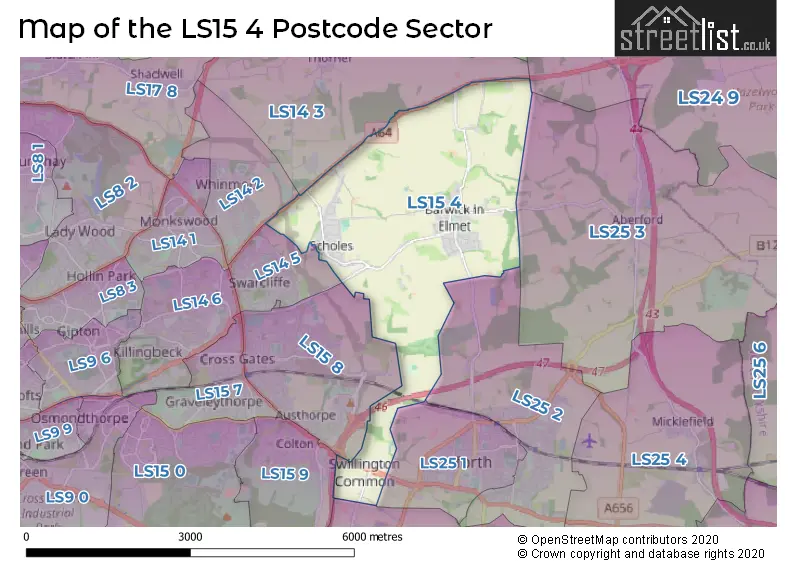
The LS15 4 Postcode shares a border with LS14 2 (LEEDS, Whinmoor), LS24 9 (TADCASTER, Church Fenton, Ulleskelf), LS25 2 (Garforth), LS25 1 (Garforth), LS14 3 (Thorner, Scarcroft, LEEDS), LS14 5 (LEEDS), LS15 8 (LEEDS, Crossgates), LS15 9 (LEEDS, Colton), LS25 3 (Aberford) and LS26 8 (Woodlesford, Oulton, Swillington).
The sector is within the post town of LEEDS.
LS15 4 is a postcode sector within the LS15 postcode district which is within the LS Leeds postcode area.
The Royal Mail delivery office for the LS15 4 postal sector is the Seacroft Delivery Office.
The area of the LS15 4 postcode sector is 6.05 square miles which is 15.67 square kilometres or 3,872.11 square acres.
The LS15 4 postcode sector is crossed by the A63 Major A road.
The LS15 4 postcode sector is crossed by the M1 motorway.
Waterways within the LS15 4 postcode sector include the Carr Beck, Cock Beck.

Map of the LS15 4 Postcode Sector
Explore the LS15 4 postcode sector by using our free interactive map.
| L | S | 1 | 5 | - | 4 | X | X |
| L | S | 1 | 5 | Space | 4 | Letter | Letter |
Official List of Streets
Barwick In Elmet (57 Streets)
Scholes (33 Streets)
LEEDS (5 Streets)
Potterton (2 Streets)
Swillington Common (3 Streets)
Unofficial Streets or Alternative Spellings
Aberford
CATTLE LANE ASS BRIDGE AUSTHORPE INTERCHANGE BARWICK ROAD BOG LANE CARRFIELD LANE CROSSLAND MEWS DARK LANE DEFINITIVE BRIDLEWAY LEEDS 119 DEFINITIVE LEEDS COUNTRY WAY / 117 ELOR YORK ROAD ROUNDABOUT HIGHFIELD LANE KIDDAL HALL FARM KIDDAL LANE COTTAGES LEEDS LANE MANGRILL LANE MANOR COTT MIRY LANE POTTERTON BRIDGE RAKE BRIDGE RING ROAD (SHADWELL) THE WARRENS THORNER LANE WOOD LANEGarforth
BARROWBY LANE NANNY GOAT LANE SELBY ROADPotterton
YORK ROADSwillington
SWILLINGTON LANEWeather Forecast for LS15 4
Press Button to Show Forecast for Stanks
| Time Period | Icon | Description | Temperature | Rain Probability | Wind |
|---|---|---|---|---|---|
| 06:00 to 09:00 | Cloudy | 3.0°C (feels like 0.0°C) | 4.00% | NNE 7 mph | |
| 09:00 to 12:00 | Cloudy | 7.0°C (feels like 5.0°C) | 7.00% | NE 9 mph | |
| 12:00 to 15:00 | Cloudy | 9.0°C (feels like 6.0°C) | 49.00% | ENE 11 mph | |
| 15:00 to 18:00 | Cloudy | 9.0°C (feels like 6.0°C) | 48.00% | NE 9 mph | |
| 18:00 to 21:00 | Cloudy | 8.0°C (feels like 5.0°C) | 13.00% | ENE 9 mph | |
| 21:00 to 00:00 | Cloudy | 6.0°C (feels like 3.0°C) | 7.00% | NE 7 mph |
Press Button to Show Forecast for Stanks
| Time Period | Icon | Description | Temperature | Rain Probability | Wind |
|---|---|---|---|---|---|
| 00:00 to 03:00 | Cloudy | 5.0°C (feels like 2.0°C) | 5.00% | NNE 9 mph | |
| 03:00 to 06:00 | Cloudy | 5.0°C (feels like 2.0°C) | 7.00% | N 9 mph | |
| 06:00 to 09:00 | Light rain | 5.0°C (feels like 2.0°C) | 49.00% | N 11 mph | |
| 09:00 to 12:00 | Light rain | 7.0°C (feels like 3.0°C) | 51.00% | N 13 mph | |
| 12:00 to 15:00 | Light rain | 8.0°C (feels like 5.0°C) | 50.00% | NW 11 mph | |
| 15:00 to 18:00 | Light rain | 10.0°C (feels like 8.0°C) | 45.00% | WNW 9 mph | |
| 18:00 to 21:00 | Partly cloudy (day) | 10.0°C (feels like 7.0°C) | 7.00% | W 9 mph | |
| 21:00 to 00:00 | Clear night | 7.0°C (feels like 4.0°C) | 1.00% | WSW 7 mph |
Press Button to Show Forecast for Stanks
| Time Period | Icon | Description | Temperature | Rain Probability | Wind |
|---|---|---|---|---|---|
| 00:00 to 03:00 | Clear night | 6.0°C (feels like 3.0°C) | 1.00% | SW 7 mph | |
| 03:00 to 06:00 | Clear night | 5.0°C (feels like 2.0°C) | 1.00% | SSW 7 mph | |
| 06:00 to 09:00 | Sunny day | 5.0°C (feels like 3.0°C) | 1.00% | S 7 mph | |
| 09:00 to 12:00 | Partly cloudy (day) | 10.0°C (feels like 8.0°C) | 2.00% | S 11 mph | |
| 12:00 to 15:00 | Cloudy | 13.0°C (feels like 10.0°C) | 5.00% | S 13 mph | |
| 15:00 to 18:00 | Cloudy | 14.0°C (feels like 11.0°C) | 7.00% | S 13 mph | |
| 18:00 to 21:00 | Partly cloudy (day) | 13.0°C (feels like 11.0°C) | 5.00% | SSE 11 mph | |
| 21:00 to 00:00 | Partly cloudy (night) | 10.0°C (feels like 8.0°C) | 2.00% | SE 9 mph |
Press Button to Show Forecast for Stanks
| Time Period | Icon | Description | Temperature | Rain Probability | Wind |
|---|---|---|---|---|---|
| 00:00 to 03:00 | Clear night | 8.0°C (feels like 6.0°C) | 2.00% | SE 9 mph | |
| 03:00 to 06:00 | Partly cloudy (night) | 6.0°C (feels like 4.0°C) | 2.00% | SE 7 mph | |
| 06:00 to 09:00 | Sunny day | 7.0°C (feels like 5.0°C) | 4.00% | ESE 7 mph | |
| 09:00 to 12:00 | Cloudy | 11.0°C (feels like 9.0°C) | 8.00% | ESE 9 mph | |
| 12:00 to 15:00 | Partly cloudy (day) | 15.0°C (feels like 13.0°C) | 7.00% | ESE 11 mph | |
| 15:00 to 18:00 | Partly cloudy (day) | 15.0°C (feels like 13.0°C) | 8.00% | ESE 11 mph | |
| 18:00 to 21:00 | Partly cloudy (day) | 14.0°C (feels like 12.0°C) | 8.00% | E 9 mph | |
| 21:00 to 00:00 | Cloudy | 11.0°C (feels like 9.0°C) | 9.00% | E 7 mph |
Schools and Places of Education Within the LS15 4 Postcode Sector
Scholes (Elmet) Primary School
Community school
Station Road, Leeds, West Yorkshire, LS15 4BJ
Head: Mr David Roundtree
Ofsted Rating: Good
Inspection: 2019-05-09 (1815 days ago)
Website: Visit Scholes (Elmet) Primary School Website
Phone: 01132649149
Number of Pupils: 350
House Prices in the LS15 4 Postcode Sector
| Type of Property | 2018 Average | 2018 Sales | 2017 Average | 2017 Sales | 2016 Average | 2016 Sales | 2015 Average | 2015 Sales |
|---|---|---|---|---|---|---|---|---|
| Detached | £350,074 | 23 | £341,696 | 23 | £325,136 | 33 | £311,923 | 39 |
| Semi-Detached | £224,735 | 38 | £215,817 | 51 | £226,492 | 37 | £190,335 | 33 |
| Terraced | £184,643 | 7 | £197,992 | 6 | £159,271 | 7 | £182,096 | 5 |
| Flats | £236,000 | 1 | £165,000 | 1 | £0 | 0 | £179,000 | 1 |
Important Postcodes LS15 4 in the Postcode Sector
LS15 4BJ is the postcode for Scholes (Elmet) Primary School, Station Road
LS15 4HL is the postcode for Barwick in Elmet C of E Primary School, Chapel Lane
| The LS15 4 Sector is within these Local Authorities |
|
|---|---|
| The LS15 4 Sector is within these Counties |
|
| The LS15 4 Sector is within these Water Company Areas |
|