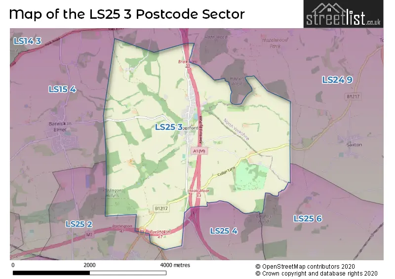
The LS25 3 postcode sector stands on the North Yorkshire and West Yorkshire border.
Did you know? According to the 2021 Census, the LS25 3 postcode sector is home to a bustling 1,560 residents!
Given that each sector allows for 400 unique postcode combinations. Letters C, I, K, M, O and V are not allowed in the last two letters of a postcode. With 67 postcodes already in use, this leaves 333 units available.
The LS25 3 postal code covers the settlement of Aberford.
The LS25 3 Postcode shares a border with LS24 9 (TADCASTER, Church Fenton, Ulleskelf), LS25 2 (Garforth), LS25 6 (Sherburn In Elmet, South Milford, Biggin), LS15 4 (Barwick In Elmet, Scholes, LEEDS) and LS25 4 (Micklefield).
The sector is within the post town of LEEDS.
LS25 3 is a postcode sector within the LS25 postcode district which is within the LS Leeds postcode area.
The Royal Mail delivery office for the LS25 3 postal sector is the Garforth Delivery Office.
The area of the LS25 3 postcode sector is 7.14 square miles which is 18.50 square kilometres or 4,570.33 square acres.
The LS25 3 postcode sector is crossed by the A1M Major A road.
The LS25 3 postcode sector is crossed by the M1 motorway.
Waterways within the LS25 3 postcode sector include the Cock Beck.

Map of the LS25 3 Postcode Sector
Explore the LS25 3 postcode sector by using our free interactive map.
| L | S | 2 | 5 | - | 3 | X | X |
| L | S | 2 | 5 | Space | 3 | Letter | Letter |
Official List of Streets
Aberford (39 Streets)
Unofficial Streets or Alternative Spellings
Weather Forecast for LS25 3
Press Button to Show Forecast for Lotherton Hall
| Time Period | Icon | Description | Temperature | Rain Probability | Wind |
|---|---|---|---|---|---|
| 18:00 to 21:00 | Cloudy | 17.0°C (feels like 15.0°C) | 3.00% | ESE 11 mph | |
| 21:00 to 00:00 | Cloudy | 12.0°C (feels like 11.0°C) | 3.00% | ESE 7 mph |
Press Button to Show Forecast for Lotherton Hall
| Time Period | Icon | Description | Temperature | Rain Probability | Wind |
|---|---|---|---|---|---|
| 00:00 to 03:00 | Cloudy | 10.0°C (feels like 9.0°C) | 3.00% | E 7 mph | |
| 03:00 to 06:00 | Cloudy | 9.0°C (feels like 8.0°C) | 5.00% | ENE 4 mph | |
| 06:00 to 09:00 | Cloudy | 10.0°C (feels like 9.0°C) | 7.00% | ENE 4 mph | |
| 09:00 to 12:00 | Cloudy | 15.0°C (feels like 15.0°C) | 3.00% | ENE 7 mph | |
| 12:00 to 15:00 | Cloudy | 20.0°C (feels like 18.0°C) | 3.00% | ESE 11 mph | |
| 15:00 to 18:00 | Cloudy | 20.0°C (feels like 18.0°C) | 11.00% | ESE 11 mph | |
| 18:00 to 21:00 | Cloudy | 18.0°C (feels like 17.0°C) | 12.00% | E 9 mph | |
| 21:00 to 00:00 | Cloudy | 14.0°C (feels like 13.0°C) | 10.00% | E 7 mph |
Press Button to Show Forecast for Lotherton Hall
| Time Period | Icon | Description | Temperature | Rain Probability | Wind |
|---|---|---|---|---|---|
| 00:00 to 03:00 | Clear night | 12.0°C (feels like 12.0°C) | 3.00% | E 4 mph | |
| 03:00 to 06:00 | Partly cloudy (night) | 11.0°C (feels like 11.0°C) | 7.00% | E 4 mph | |
| 06:00 to 09:00 | Cloudy | 13.0°C (feels like 13.0°C) | 9.00% | SE 4 mph | |
| 09:00 to 12:00 | Cloudy | 17.0°C (feels like 15.0°C) | 10.00% | SSE 9 mph | |
| 12:00 to 15:00 | Cloudy | 18.0°C (feels like 16.0°C) | 14.00% | S 11 mph | |
| 15:00 to 18:00 | Cloudy | 19.0°C (feels like 16.0°C) | 14.00% | SSE 13 mph | |
| 18:00 to 21:00 | Cloudy | 17.0°C (feels like 15.0°C) | 16.00% | SSE 11 mph | |
| 21:00 to 00:00 | Overcast | 15.0°C (feels like 13.0°C) | 25.00% | SE 11 mph |
Press Button to Show Forecast for Lotherton Hall
| Time Period | Icon | Description | Temperature | Rain Probability | Wind |
|---|---|---|---|---|---|
| 00:00 to 03:00 | Light rain | 14.0°C (feels like 12.0°C) | 54.00% | SE 11 mph | |
| 03:00 to 06:00 | Light rain | 13.0°C (feels like 12.0°C) | 52.00% | SE 9 mph | |
| 06:00 to 09:00 | Light rain | 13.0°C (feels like 12.0°C) | 55.00% | SE 9 mph | |
| 09:00 to 12:00 | Light rain | 14.0°C (feels like 13.0°C) | 50.00% | SSE 9 mph | |
| 12:00 to 15:00 | Light rain shower (day) | 16.0°C (feels like 14.0°C) | 44.00% | SE 11 mph | |
| 15:00 to 18:00 | Light rain shower (day) | 17.0°C (feels like 15.0°C) | 41.00% | SSE 11 mph | |
| 18:00 to 21:00 | Light rain shower (day) | 16.0°C (feels like 14.0°C) | 38.00% | SSE 11 mph | |
| 21:00 to 00:00 | Clear night | 14.0°C (feels like 12.0°C) | 6.00% | SE 9 mph |
Press Button to Show Forecast for Lotherton Hall
| Time Period | Icon | Description | Temperature | Rain Probability | Wind |
|---|---|---|---|---|---|
| 00:00 to 03:00 | Partly cloudy (night) | 12.0°C (feels like 10.0°C) | 3.00% | SSE 9 mph | |
| 03:00 to 06:00 | Partly cloudy (night) | 11.0°C (feels like 9.0°C) | 3.00% | SE 7 mph | |
| 06:00 to 09:00 | Overcast | 12.0°C (feels like 10.0°C) | 8.00% | SE 9 mph | |
| 09:00 to 12:00 | Cloudy | 15.0°C (feels like 13.0°C) | 10.00% | SSE 11 mph | |
| 12:00 to 15:00 | Light rain shower (day) | 17.0°C (feels like 15.0°C) | 30.00% | SSE 11 mph | |
| 15:00 to 18:00 | Light rain shower (day) | 17.0°C (feels like 15.0°C) | 34.00% | SSE 11 mph | |
| 18:00 to 21:00 | Light rain shower (day) | 16.0°C (feels like 15.0°C) | 32.00% | SSE 9 mph | |
| 21:00 to 00:00 | Clear night | 13.0°C (feels like 12.0°C) | 1.00% | SSE 7 mph |
Schools and Places of Education Within the LS25 3 Postcode Sector
Aberford Church of England Voluntary Controlled Primary School
Voluntary controlled school
School Lane, Leeds, West Yorkshire, LS25 3BU
Head: Mrs Nicola Crossley
Ofsted Rating: Good
Inspection: 2018-09-18 (2062 days ago)
Website: Visit Aberford Church of England Voluntary Controlled Primary School Website
Phone: 01132813302
Number of Pupils: 107
House Prices in the LS25 3 Postcode Sector
| Type of Property | 2018 Average | 2018 Sales | 2017 Average | 2017 Sales | 2016 Average | 2016 Sales | 2015 Average | 2015 Sales |
|---|---|---|---|---|---|---|---|---|
| Detached | £448,038 | 13 | £507,438 | 8 | £408,625 | 12 | £322,897 | 15 |
| Semi-Detached | £276,000 | 5 | £334,833 | 3 | £230,300 | 5 | £233,056 | 8 |
| Terraced | £358,667 | 3 | £221,730 | 5 | £180,811 | 4 | £247,438 | 8 |
| Flats | £0 | 0 | £138,000 | 1 | £90,000 | 1 | £113,000 | 1 |
Important Postcodes LS25 3 in the Postcode Sector
LS25 3BU is the postcode for Aberford C of E Primary School, School Lane
LS25 3EB is the postcode for Lotherton Hall, Lotherton Lane
| The LS25 3 Sector is within these Local Authorities |
|
|---|---|
| The LS25 3 Sector is within these Counties |
|
| The LS25 3 Sector is within these Water Company Areas |
|
Tourist Attractions within the LS25 3 Postcode Area
We found 1 visitor attractions within the LS25 postcode area
| Lotherton Hall & Gardens |
|---|
| Museums & Art Galleries |
| Museum and / or Art Gallery |
| View Lotherton Hall & Gardens on Google Maps |