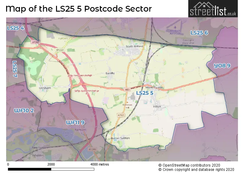
The LS25 5 postcode sector stands on the North Yorkshire and West Yorkshire border.
Did you know? According to the 2021 Census, the LS25 5 postcode sector is home to a bustling 5,062 residents!
Given that each sector allows for 400 unique postcode combinations. Letters C, I, K, M, O and V are not allowed in the last two letters of a postcode. With 190 postcodes already in use, this leaves 210 units available.
The largest settlement in the LS25 5 postal code is South Milford followed by Monk Fryston, and Hillam.
The LS25 5 Postcode shares a border with LS25 6 (Sherburn In Elmet, South Milford, Biggin), LS25 7 (Kippax, LEEDS), WF10 2 (Allerton Bywater, CASTLEFORD, Ledston), WF11 9 (KNOTTINGLEY, Byram, Brotherton), YO8 9 (Thorpe Willoughby, Brayton, SELBY) and LS25 4 (Micklefield).
The sector is within the post town of LEEDS.
LS25 5 is a postcode sector within the LS25 postcode district which is within the LS Leeds postcode area.
The Royal Mail delivery office for the LS25 5 postal sector is the Sherburn (ls) Delivery Office.
The area of the LS25 5 postcode sector is 13.46 square miles which is 34.85 square kilometres or 8,612.70 square acres.
The LS25 5 postcode sector is crossed by the A1M Major A road.
The LS25 5 postcode sector is crossed by the A63 Major A road.

Map of the LS25 5 Postcode Sector
Explore the LS25 5 postcode sector by using our free interactive map.
| L | S | 2 | 5 | - | 5 | X | X |
| L | S | 2 | 5 | Space | 5 | Letter | Letter |
Official List of Streets
Monk Fryston (28 Streets)
Hillam (22 Streets)
South Milford (73 Streets)
Burton Salmon (16 Streets)
Unofficial Streets or Alternative Spellings
South Milford
GORSE LANE SIR JOHN LEWIS COTTAGES BOOT & SHOE BULLYTREE LANE BURTON COMMON LANE BUTTS LANE CASS LANE DUNCE MIRE ROAD FOX LANE HARVESTER WAY JQASMINE COURT LONG HEADS LANE LOWFIELD ROAD LUNNFIELD LANE LUNNFIELDS LANE MEADOW LANE NORTHFIELD LANE OLD QUARRY LANE RED HILL LANE SELBY FORK INTERCHANGE SELBY FORK ROUNDABOUT STOCKING LANE STONE HOUSE FARM THE QUARRY TOM LANE WESTFIELD COURT WHIN LANE WHITECOTE LANEBirkin
ROE LANESherburn In Elmet
MILFORD ROADGarforth
SELBY ROADGateforth
HILLAM ROADFairburn
RAWFIELD LANEAberford
GREAT NORTH ROADWeather Forecast for LS25 5
Press Button to Show Forecast for Wheldale
| Time Period | Icon | Description | Temperature | Rain Probability | Wind |
|---|---|---|---|---|---|
| 09:00 to 12:00 | Cloudy | 8.0°C (feels like 6.0°C) | 13.00% | NE 9 mph | |
| 12:00 to 15:00 | Overcast | 9.0°C (feels like 6.0°C) | 16.00% | ENE 9 mph | |
| 15:00 to 18:00 | Overcast | 9.0°C (feels like 7.0°C) | 19.00% | ENE 9 mph | |
| 18:00 to 21:00 | Cloudy | 8.0°C (feels like 6.0°C) | 9.00% | ENE 9 mph | |
| 21:00 to 00:00 | Cloudy | 6.0°C (feels like 4.0°C) | 6.00% | NE 7 mph |
Press Button to Show Forecast for Wheldale
| Time Period | Icon | Description | Temperature | Rain Probability | Wind |
|---|---|---|---|---|---|
| 00:00 to 03:00 | Cloudy | 5.0°C (feels like 2.0°C) | 7.00% | NNE 9 mph | |
| 03:00 to 06:00 | Overcast | 5.0°C (feels like 2.0°C) | 13.00% | N 9 mph | |
| 06:00 to 09:00 | Light rain | 6.0°C (feels like 2.0°C) | 55.00% | N 11 mph | |
| 09:00 to 12:00 | Light rain | 7.0°C (feels like 3.0°C) | 54.00% | N 11 mph | |
| 12:00 to 15:00 | Light rain | 8.0°C (feels like 5.0°C) | 51.00% | NW 11 mph | |
| 15:00 to 18:00 | Cloudy | 10.0°C (feels like 8.0°C) | 15.00% | WNW 9 mph | |
| 18:00 to 21:00 | Partly cloudy (day) | 10.0°C (feels like 8.0°C) | 7.00% | W 9 mph | |
| 21:00 to 00:00 | Clear night | 7.0°C (feels like 5.0°C) | 2.00% | WSW 7 mph |
Press Button to Show Forecast for Wheldale
| Time Period | Icon | Description | Temperature | Rain Probability | Wind |
|---|---|---|---|---|---|
| 00:00 to 03:00 | Clear night | 6.0°C (feels like 4.0°C) | 1.00% | SW 7 mph | |
| 03:00 to 06:00 | Clear night | 5.0°C (feels like 3.0°C) | 1.00% | SSW 7 mph | |
| 06:00 to 09:00 | Sunny day | 6.0°C (feels like 4.0°C) | 1.00% | S 7 mph | |
| 09:00 to 12:00 | Sunny day | 11.0°C (feels like 8.0°C) | 1.00% | S 11 mph | |
| 12:00 to 15:00 | Partly cloudy (day) | 13.0°C (feels like 11.0°C) | 2.00% | S 13 mph | |
| 15:00 to 18:00 | Cloudy | 14.0°C (feels like 12.0°C) | 6.00% | S 13 mph | |
| 18:00 to 21:00 | Partly cloudy (day) | 13.0°C (feels like 11.0°C) | 2.00% | SSE 11 mph | |
| 21:00 to 00:00 | Clear night | 11.0°C (feels like 9.0°C) | 2.00% | SE 9 mph |
Press Button to Show Forecast for Wheldale
| Time Period | Icon | Description | Temperature | Rain Probability | Wind |
|---|---|---|---|---|---|
| 00:00 to 03:00 | Clear night | 9.0°C (feels like 7.0°C) | 1.00% | SE 9 mph | |
| 03:00 to 06:00 | Partly cloudy (night) | 7.0°C (feels like 5.0°C) | 2.00% | ESE 7 mph | |
| 06:00 to 09:00 | Cloudy | 8.0°C (feels like 6.0°C) | 5.00% | ESE 7 mph | |
| 09:00 to 12:00 | Partly cloudy (day) | 12.0°C (feels like 10.0°C) | 4.00% | ESE 9 mph | |
| 12:00 to 15:00 | Cloudy | 15.0°C (feels like 13.0°C) | 10.00% | ESE 11 mph | |
| 15:00 to 18:00 | Cloudy | 16.0°C (feels like 13.0°C) | 12.00% | ESE 11 mph | |
| 18:00 to 21:00 | Partly cloudy (day) | 14.0°C (feels like 12.0°C) | 11.00% | E 9 mph | |
| 21:00 to 00:00 | Cloudy | 11.0°C (feels like 10.0°C) | 11.00% | E 7 mph |
Schools and Places of Education Within the LS25 5 Postcode Sector
Burton Salmon Community Primary School
Community school
Burton Salmon, Leeds, North Yorkshire, LS25 5JY
Head: Mrs Suzanne MacDonald
Ofsted Rating: Good
Inspection: 2023-10-18 (192 days ago)
Website: Visit Burton Salmon Community Primary School Website
Phone: 01977672405
Number of Pupils: 66
Monk Fryston Church of England Primary School
Academy converter
Chestnut Green, Leeds, West Yorkshire, LS25 5PN
Head: Mr Rick Weights
Ofsted Rating: Good
Inspection: 2022-07-13 (654 days ago)
Website: Visit Monk Fryston Church of England Primary School Website
Phone: 01977682388
Number of Pupils: 208
South Milford Primary School
Academy converter
Sand Lane, Leeds, North Yorkshire, LS25 5AU
Head: Headteacher Melanie Lawrence
Ofsted Rating: Good
Inspection: 2022-10-19 (556 days ago)
Website: Visit South Milford Primary School Website
Phone: 01977682359
Number of Pupils: 203
House Prices in the LS25 5 Postcode Sector
| Type of Property | 2018 Average | 2018 Sales | 2017 Average | 2017 Sales | 2016 Average | 2016 Sales | 2015 Average | 2015 Sales |
|---|---|---|---|---|---|---|---|---|
| Detached | £396,699 | 45 | £343,967 | 49 | £327,416 | 46 | £327,733 | 38 |
| Semi-Detached | £195,694 | 27 | £179,441 | 17 | £190,263 | 22 | £177,712 | 21 |
| Terraced | £202,999 | 26 | £183,785 | 36 | £162,888 | 29 | £156,889 | 37 |
| Flats | £135,500 | 2 | £123,500 | 2 | £129,000 | 3 | £110,667 | 3 |
Important Postcodes LS25 5 in the Postcode Sector
LS25 5AA is the postcode for South Milford Surgery, 14 High Street
LS25 5AU is the postcode for South Milford Primary School, Sand Lane, South Milford Cp School, Sand Lane, South Milford, MAIN BUILDING, South Milford Cp School, Sand Lane, and MAIN BUILDING, South Milford Primary School, Sand Lane
LS25 5PN is the postcode for MAIN BUILDING, Monk Fryston C of E Primary School, Chestnut Green, and Monk Fryston C of E Primary School, Chestnut Green
| The LS25 5 Sector is within these Local Authorities |
|
|---|---|
| The LS25 5 Sector is within these Counties |
|
| The LS25 5 Sector is within these Water Company Areas |
|