The LS29 6 postcode sector is within the county of West Yorkshire.
Did you know? According to the 2021 Census, the LS29 6 postcode sector is home to a bustling 6,381 residents!
Given that each sector allows for 400 unique postcode combinations. Letters C, I, K, M, O and V are not allowed in the last two letters of a postcode. With 230 postcodes already in use, this leaves 170 units available.
The LS29 6 postal code covers the settlement of Menston.
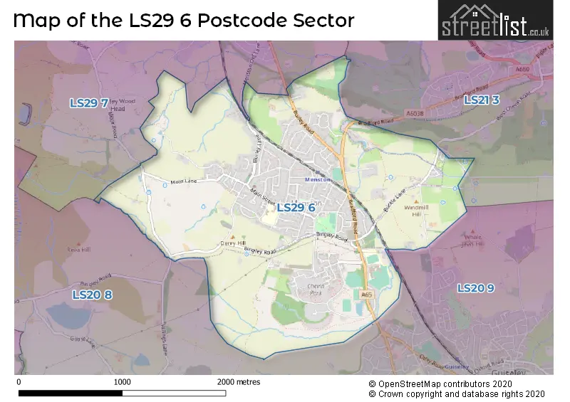
The LS29 6 Postcode shares a border with LS20 8 (Guiseley, Hawksworth), LS21 3 (OTLEY, Pool In Wharfedale), LS20 9 (Guiseley) and LS29 7 (Burley In Wharfedale, Burley Woodhead).
The sector is within the post town of ILKLEY.
LS29 6 is a postcode sector within the LS29 postcode district which is within the LS Leeds postcode area.
The Royal Mail delivery office for the LS29 6 postal sector is the Ilkley Delivery Office.
The area of the LS29 6 postcode sector is 2.32 square miles which is 6.02 square kilometres or 1,487.93 square acres.
Waterways within the LS29 6 postcode sector include the Carr Beck, Mire Beck.

Map of the LS29 6 Postcode Sector
Explore the LS29 6 postcode sector by using our free interactive map.
| L | S | 2 | 9 | - | 6 | X | X |
| L | S | 2 | 9 | Space | 6 | Letter | Letter |
Official List of Streets
Menston (152 Streets)
Unofficial Streets or Alternative Spellings
Guiseley
BRADFORD ROAD CHEVIN END ROAD MOOR TOPMenston
BRAUNSTONE COURTOTLEY
BRADFORD ROADHawksworth
HILLINGS LANEBurley In Wharfedale
HAG FARM ROAD MENSTON OLD LANEBurley Woodhead
MOOR ROAD STONEY LANEWeather Forecast for LS29 6
Press Button to Show Forecast for Guiseley
| Time Period | Icon | Description | Temperature | Rain Probability | Wind |
|---|---|---|---|---|---|
| 21:00 to 00:00 | Cloudy | 5.0°C (feels like 3.0°C) | 5.00% | ENE 4 mph |
Press Button to Show Forecast for Guiseley
| Time Period | Icon | Description | Temperature | Rain Probability | Wind |
|---|---|---|---|---|---|
| 00:00 to 03:00 | Partly cloudy (night) | 3.0°C (feels like 1.0°C) | 1.00% | NE 4 mph | |
| 03:00 to 06:00 | Partly cloudy (night) | 2.0°C (feels like 0.0°C) | 1.00% | NNE 4 mph | |
| 06:00 to 09:00 | Partly cloudy (day) | 3.0°C (feels like 1.0°C) | 2.00% | NNE 4 mph | |
| 09:00 to 12:00 | Cloudy | 7.0°C (feels like 4.0°C) | 11.00% | ENE 9 mph | |
| 12:00 to 15:00 | Overcast | 8.0°C (feels like 6.0°C) | 12.00% | ENE 11 mph | |
| 15:00 to 18:00 | Cloudy | 8.0°C (feels like 5.0°C) | 17.00% | ENE 9 mph | |
| 18:00 to 21:00 | Overcast | 7.0°C (feels like 4.0°C) | 14.00% | NE 9 mph | |
| 21:00 to 00:00 | Cloudy | 5.0°C (feels like 3.0°C) | 6.00% | NE 7 mph |
Press Button to Show Forecast for Guiseley
| Time Period | Icon | Description | Temperature | Rain Probability | Wind |
|---|---|---|---|---|---|
| 00:00 to 03:00 | Cloudy | 4.0°C (feels like 1.0°C) | 4.00% | NNE 7 mph | |
| 03:00 to 06:00 | Cloudy | 4.0°C (feels like 1.0°C) | 6.00% | NNE 9 mph | |
| 06:00 to 09:00 | Cloudy | 5.0°C (feels like 1.0°C) | 17.00% | N 11 mph | |
| 09:00 to 12:00 | Light rain | 6.0°C (feels like 3.0°C) | 50.00% | N 11 mph | |
| 12:00 to 15:00 | Heavy rain | 8.0°C (feels like 5.0°C) | 70.00% | NW 11 mph | |
| 15:00 to 18:00 | Light rain | 10.0°C (feels like 7.0°C) | 45.00% | WNW 11 mph | |
| 18:00 to 21:00 | Partly cloudy (day) | 9.0°C (feels like 7.0°C) | 7.00% | W 9 mph | |
| 21:00 to 00:00 | Clear night | 6.0°C (feels like 3.0°C) | 2.00% | WSW 7 mph |
Press Button to Show Forecast for Guiseley
| Time Period | Icon | Description | Temperature | Rain Probability | Wind |
|---|---|---|---|---|---|
| 00:00 to 03:00 | Clear night | 5.0°C (feels like 3.0°C) | 1.00% | SW 7 mph | |
| 03:00 to 06:00 | Clear night | 4.0°C (feels like 2.0°C) | 1.00% | SW 7 mph | |
| 06:00 to 09:00 | Sunny day | 6.0°C (feels like 3.0°C) | 2.00% | SSW 7 mph | |
| 09:00 to 12:00 | Partly cloudy (day) | 10.0°C (feels like 7.0°C) | 2.00% | SSW 11 mph | |
| 12:00 to 15:00 | Overcast | 12.0°C (feels like 10.0°C) | 10.00% | S 13 mph | |
| 15:00 to 18:00 | Cloudy | 13.0°C (feels like 10.0°C) | 7.00% | S 13 mph | |
| 18:00 to 21:00 | Cloudy | 12.0°C (feels like 10.0°C) | 7.00% | S 11 mph | |
| 21:00 to 00:00 | Clear night | 10.0°C (feels like 8.0°C) | 3.00% | SSE 9 mph |
Press Button to Show Forecast for Guiseley
| Time Period | Icon | Description | Temperature | Rain Probability | Wind |
|---|---|---|---|---|---|
| 00:00 to 03:00 | Clear night | 8.0°C (feels like 6.0°C) | 3.00% | SSE 7 mph | |
| 03:00 to 06:00 | Partly cloudy (night) | 6.0°C (feels like 4.0°C) | 3.00% | SE 7 mph | |
| 06:00 to 09:00 | Sunny day | 7.0°C (feels like 5.0°C) | 4.00% | ESE 7 mph | |
| 09:00 to 12:00 | Partly cloudy (day) | 10.0°C (feels like 8.0°C) | 7.00% | ESE 9 mph | |
| 12:00 to 15:00 | Partly cloudy (day) | 14.0°C (feels like 12.0°C) | 8.00% | ESE 11 mph | |
| 15:00 to 18:00 | Partly cloudy (day) | 15.0°C (feels like 12.0°C) | 11.00% | ESE 11 mph | |
| 18:00 to 21:00 | Partly cloudy (day) | 13.0°C (feels like 11.0°C) | 8.00% | E 11 mph | |
| 21:00 to 00:00 | Cloudy | 10.0°C (feels like 9.0°C) | 10.00% | E 9 mph |
Schools and Places of Education Within the LS29 6 Postcode Sector
St. Mary's Menston, a Catholic Voluntary Academy
Academy converter
Bradford Road, Ilkley, West Yorkshire, LS29 6AE
Head: Miss Margaret Hattersley
Ofsted Rating: Outstanding
Inspection: 2014-11-26 (3439 days ago)
Website: Visit St. Mary's Menston, a Catholic Voluntary Academy Website
Phone: 01943883000
Number of Pupils: 1228
House Prices in the LS29 6 Postcode Sector
| Type of Property | 2018 Average | 2018 Sales | 2017 Average | 2017 Sales | 2016 Average | 2016 Sales | 2015 Average | 2015 Sales |
|---|---|---|---|---|---|---|---|---|
| Detached | £550,825 | 41 | £507,265 | 51 | £448,744 | 41 | £507,358 | 50 |
| Semi-Detached | £339,183 | 30 | £282,884 | 43 | £308,252 | 39 | £296,248 | 45 |
| Terraced | £279,097 | 26 | £260,843 | 30 | £249,423 | 35 | £282,507 | 52 |
| Flats | £162,658 | 32 | £169,780 | 72 | £160,230 | 74 | £162,044 | 57 |
Important Postcodes LS29 6 in the Postcode Sector
LS29 6AE is the postcode for St. Marys School, Bradford Road, and St. Marys School, Bradford Road, Menston
LS29 6HP is the postcode for MEADOWLEA COMMUNITY CHILDREN'S HOME, 45, Hawksworth Drive, Menston
LS29 6HT is the postcode for Kirklands Community Centre, Kirklands, Main Street
LS29 6LF is the postcode for KS2 BUILDING, Menston Primary School, 56 Main Street, LINK BUILDING, Menston Primary School, 56 Main Street, and KS1 BUILDING, Menston Primary School, 56 Main Street
| The LS29 6 Sector is within these Local Authorities |
|
|---|---|
| The LS29 6 Sector is within these Counties |
|
| The LS29 6 Sector is within these Water Company Areas |
|