The LS9 7 postcode sector is within the county of West Yorkshire.
Did you know? According to the 2021 Census, the LS9 7 postcode sector is home to a bustling 9,096 residents!
Given that each sector allows for 400 unique postcode combinations. Letters C, I, K, M, O and V are not allowed in the last two letters of a postcode. With 179 postcodes already in use, this leaves 221 units available.
The LS9 7 postal code covers the settlement of LEEDS.
The LS9 7 Postcode shares a border with LS7 1 (LEEDS), LS8 3 (LEEDS, Gipton), LS9 6 (LEEDS), LS9 8 (LEEDS), LS2 7 (LEEDS), LS8 5 (LEEDS) and LS9 9 (LEEDS).
The sector is within the post town of LEEDS.
LS9 7 is a postcode sector within the LS9 postcode district which is within the LS Leeds postcode area.
The Royal Mail delivery office for the LS9 7 postal sector is the York Road Delivery Office.
The area of the LS9 7 postcode sector is 0.62 square miles which is 1.60 square kilometres or 396.45 square acres.

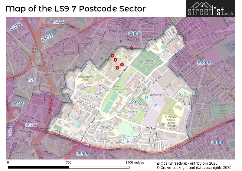
Map of the LS9 7 Postcode Sector
Explore the LS9 7 postcode sector by using our free interactive map.
| L | S | 9 | - | 7 | X | X |
| L | S | 9 | Space | 7 | Letter | Letter |
Official List of Streets
LEEDS (121 Streets)
Unofficial Streets or Alternative Spellings
LEEDS
ASHTON GROVE ASHTON MOUNT ASHTON PLACE ASHTON ROAD CHERRY COURT CLIFTON AVENUE CLIFTON GROVE CLIFTON MOUNT CLIFTON TERRACE COWPER GROVE DARFIELD AVENUE DARFIELD CRESCENT DARFIELD ROAD EASTGATE FIRTH TERRACE HUDSON GROVE MARSH LANE REGENT STREET SKINNER LANE STRATHMORE DRIVE STRATHMORE VIEW TEMPLE VIEW ROAD ACCOMMODATION ROAD ANGLICAN WALK APPLETON COURT ARGYLE ROAD ASHLEY STREET BACK ASHLEY AVENUE BACK ASHLEY STREET BACK COWPER GROVE BACK GLENTHORPE MOUNT BACK GLENTHORPE TERRACE BACK STANLEY STREET BACK WESTLOCK AVENUE BURTON WAY CHAPMAN STREET CROSS BELL STREET DISSENTERS WALK INDUSTRIAL STREET INNER RING ROAD LINCOLN FIELD ROW LINDSEY GARDENS MOOREHOUSE GROVE MUSEUM STREET NASEBY GARTH NASEBY TERRACE RECTORY STREET RUBY STREET SAINT MARYS LANE SAINT MARYS STREET SHAKESPEARE AVENUE SHAKESPEARE STREET SHAKESPEARE VALE SHAKESPEARE WALK TELEPHONE PLACE TRENT ROAD UPPER WESTLOCK AVENUEPotterton
YORK ROADWeather Forecast for LS9 7
Press Button to Show Forecast for Osmondthorpe
| Time Period | Icon | Description | Temperature | Rain Probability | Wind |
|---|---|---|---|---|---|
| 21:00 to 00:00 | Cloudy | 6.0°C (feels like 4.0°C) | 4.00% | ENE 7 mph |
Press Button to Show Forecast for Osmondthorpe
| Time Period | Icon | Description | Temperature | Rain Probability | Wind |
|---|---|---|---|---|---|
| 00:00 to 03:00 | Partly cloudy (night) | 5.0°C (feels like 3.0°C) | 1.00% | NE 4 mph | |
| 03:00 to 06:00 | Partly cloudy (night) | 3.0°C (feels like 1.0°C) | 1.00% | NNE 7 mph | |
| 06:00 to 09:00 | Cloudy | 4.0°C (feels like 1.0°C) | 4.00% | NNE 7 mph | |
| 09:00 to 12:00 | Cloudy | 7.0°C (feels like 5.0°C) | 9.00% | NE 9 mph | |
| 12:00 to 15:00 | Overcast | 9.0°C (feels like 7.0°C) | 49.00% | NE 9 mph | |
| 15:00 to 18:00 | Overcast | 9.0°C (feels like 7.0°C) | 48.00% | NE 9 mph | |
| 18:00 to 21:00 | Cloudy | 8.0°C (feels like 6.0°C) | 12.00% | ENE 9 mph | |
| 21:00 to 00:00 | Cloudy | 7.0°C (feels like 4.0°C) | 7.00% | NE 7 mph |
Press Button to Show Forecast for Osmondthorpe
| Time Period | Icon | Description | Temperature | Rain Probability | Wind |
|---|---|---|---|---|---|
| 00:00 to 03:00 | Cloudy | 5.0°C (feels like 3.0°C) | 5.00% | NNE 7 mph | |
| 03:00 to 06:00 | Cloudy | 5.0°C (feels like 2.0°C) | 8.00% | N 9 mph | |
| 06:00 to 09:00 | Light rain | 6.0°C (feels like 2.0°C) | 50.00% | N 11 mph | |
| 09:00 to 12:00 | Light rain | 7.0°C (feels like 4.0°C) | 51.00% | N 11 mph | |
| 12:00 to 15:00 | Light rain | 8.0°C (feels like 5.0°C) | 50.00% | NW 11 mph | |
| 15:00 to 18:00 | Light rain | 10.0°C (feels like 8.0°C) | 46.00% | WNW 9 mph | |
| 18:00 to 21:00 | Partly cloudy (day) | 10.0°C (feels like 8.0°C) | 7.00% | W 9 mph | |
| 21:00 to 00:00 | Clear night | 8.0°C (feels like 6.0°C) | 2.00% | WSW 7 mph |
Press Button to Show Forecast for Osmondthorpe
| Time Period | Icon | Description | Temperature | Rain Probability | Wind |
|---|---|---|---|---|---|
| 00:00 to 03:00 | Clear night | 6.0°C (feels like 4.0°C) | 1.00% | SW 7 mph | |
| 03:00 to 06:00 | Clear night | 5.0°C (feels like 3.0°C) | 1.00% | SSW 7 mph | |
| 06:00 to 09:00 | Sunny day | 6.0°C (feels like 4.0°C) | 1.00% | S 7 mph | |
| 09:00 to 12:00 | Partly cloudy (day) | 11.0°C (feels like 8.0°C) | 2.00% | S 11 mph | |
| 12:00 to 15:00 | Cloudy | 13.0°C (feels like 11.0°C) | 6.00% | S 13 mph | |
| 15:00 to 18:00 | Cloudy | 14.0°C (feels like 11.0°C) | 7.00% | S 13 mph | |
| 18:00 to 21:00 | Partly cloudy (day) | 13.0°C (feels like 11.0°C) | 4.00% | SSE 11 mph | |
| 21:00 to 00:00 | Clear night | 11.0°C (feels like 9.0°C) | 2.00% | SSE 9 mph |
Press Button to Show Forecast for Osmondthorpe
| Time Period | Icon | Description | Temperature | Rain Probability | Wind |
|---|---|---|---|---|---|
| 00:00 to 03:00 | Clear night | 9.0°C (feels like 7.0°C) | 2.00% | SE 7 mph | |
| 03:00 to 06:00 | Partly cloudy (night) | 7.0°C (feels like 5.0°C) | 2.00% | SE 7 mph | |
| 06:00 to 09:00 | Sunny day | 7.0°C (feels like 6.0°C) | 4.00% | ESE 7 mph | |
| 09:00 to 12:00 | Cloudy | 11.0°C (feels like 9.0°C) | 7.00% | ESE 9 mph | |
| 12:00 to 15:00 | Partly cloudy (day) | 15.0°C (feels like 13.0°C) | 5.00% | ESE 11 mph | |
| 15:00 to 18:00 | Partly cloudy (day) | 16.0°C (feels like 13.0°C) | 9.00% | ESE 11 mph | |
| 18:00 to 21:00 | Partly cloudy (day) | 14.0°C (feels like 13.0°C) | 7.00% | E 9 mph | |
| 21:00 to 00:00 | Cloudy | 12.0°C (feels like 10.0°C) | 8.00% | E 7 mph |
Schools and Places of Education Within the LS9 7 Postcode Sector
Co-op Academy Brownhill
Academy sponsor led
Torre Drive, Leeds, , LS9 7DH
Head: Beverley Blanchfield
Ofsted Rating: Good
Inspection: 2023-07-04 (297 days ago)
Website: Visit Co-op Academy Brownhill Website
Phone: 01132489539
Number of Pupils: 444
Co-op Academy Leeds
Academy sponsor led
Stoney Rock Lane, Leeds, West Yorkshire, LS9 7HD
Head: Miss Natalie Jones
Ofsted Rating: Good
Inspection: 2022-11-30 (513 days ago)
Website: Visit Co-op Academy Leeds Website
Phone: 01133807940
Number of Pupils: 861
Co-op Academy Nightingale
Academy sponsor led
Stanley Road, Leeds, West Yorkshire, LS9 7AX
Head: Mrs Beverley Blanchfield
Ofsted Rating: Good
Inspection: 2022-06-29 (667 days ago)
Website: Visit Co-op Academy Nightingale Website
Phone: 01132359164
Number of Pupils: 415
Ebor Gardens Primary Academy
Academy sponsor led
Ebor Gardens Primary Academy, Leeds, West Yorkshire, LS9 7PY
Head: Mrs Natalie Wathen
Ofsted Rating: Good
Inspection: 2019-03-21 (1863 days ago)
Website: Visit Ebor Gardens Primary Academy Website
Phone: 01132482750
Number of Pupils: 421
Shakespeare Primary School
Community school
Lincoln Road, Leeds, West Yorkshire, LS9 7NP
Head: Mr Julian Gorton
Ofsted Rating: Good
Inspection: 2019-01-09 (1934 days ago)
Website: Visit Shakespeare Primary School Website
Phone: 01135351000
Number of Pupils: 731
St Patrick Catholic Primary School
Voluntary aided school
Torre Road, Leeds, West Yorkshire, LS9 7QL
Head: Mrs Claire Grady
Ofsted Rating: Good
Inspection: 2018-11-08 (1996 days ago)
Website: Visit St Patrick Catholic Primary School Website
Phone: 01132480380
Number of Pupils: 208
St Peter's Church of England Primary School, Leeds
Voluntary aided school
Cromwell Street, Leeds, West Yorkshire, LS9 7SG
Head: Mrs Elizabeth Holliday
Ofsted Rating: Outstanding
Inspection: 2023-11-23 (155 days ago)
Website: Visit St Peter's Church of England Primary School, Leeds Website
Phone: 01132934411
Number of Pupils: 260
House Prices in the LS9 7 Postcode Sector
| Type of Property | 2018 Average | 2018 Sales | 2017 Average | 2017 Sales | 2016 Average | 2016 Sales | 2015 Average | 2015 Sales |
|---|---|---|---|---|---|---|---|---|
| Detached | £340,000 | 1 | £131,500 | 2 | £0 | 0 | £0 | 0 |
| Semi-Detached | £90,167 | 3 | £87,800 | 5 | £95,500 | 3 | £99,667 | 3 |
| Terraced | £92,250 | 16 | £85,621 | 32 | £75,314 | 35 | £68,067 | 23 |
| Flats | £63,273 | 9 | £74,563 | 4 | £83,056 | 9 | £59,158 | 6 |
Important Postcodes LS9 7 in the Postcode Sector
LS9 7AX is the postcode for NIGHTINGALE PRIMARY ACADEMY, STANLEY ROAD, HAREHILLS, and Nightingale Primary Academy, Stanley Road
LS9 7BA is the postcode for HAREHILLS CHILDRENS CENTRE, COWPER TERRACE, HAREHILLS
LS9 7BE is the postcode for Leeds & York Partnership NHS Foundation Trust, Becklin Centre, Alma Street, and Becklin Centre, Alma Street
LS9 7BG is the postcode for THE COMPTON CENTRE, 322 HAREHILLS LANE, and The Compton Centre, Cowper Terrace
LS9 7DH is the postcode for Co-op Brownhill Academy, Torre Drive, and Co-op Academy Brownhill, Torre Drive
LS9 7HD is the postcode for BLOCK A, Co-op Academy of Leeds, Stoney Rock Lane, BLOCK D, Co-op Academy of Leeds, Stoney Rock Lane, BLOCK C, Co-op Academy of Leeds, Stoney Rock Lane, BLOCK B, Co-op Academy of Leeds, Stoney Rock Lane, and SILC, Co-op Academy of Leeds, Stoney Rock Lane
LS9 7HP is the postcode for Shakespeare Primary School, Shakespeare Avenue
LS9 7NP is the postcode for Shakespeare Primary School, Lincoln Road, and Shakespeare Primary School, Lincoln Road, Burmantofts
LS9 7PS is the postcode for Haslewood Community Centre, Haslewood Drive
LS9 7PY is the postcode for Ebor Gardens Primary School, Rigton Drive
LS9 7QL is the postcode for SPORTS BLOCK, TRINITY ACADEMY LEEDS, TORRE ROAD, St. Patricks Catholic Primary School, Torre Road, and MAIN SCHOOL, TRINITY ACADEMY LEEDS, TORRE ROAD
LS9 7QQ is the postcode for Leeds City Council, 225a York Road
LS9 7RY is the postcode for Leeds City Council, 225 York Road
LS9 7SG is the postcode for St. Peters C of E Primary School, Cromwell Street
LS9 7TA is the postcode for BURMANTOFTS HEALTH CENTRE, Leeds Community Healthcare NHS Trust, Cromwell Mount, and Leeds Community Healthcare NHS Trust, Cromwell Mount
LS9 7TF is the postcode for CLINICAL, BRENNER, OGDEN & CANCER RESEARCH, St. James's University Hospital, Beckett Street, CHILD PSYCHIATRIC UNIT ST. JAMES'S UNIVERSITY HOSPITAL, St. James's University Hospital, Beckett Street, BECKETT WING, St. James's University Hospital, Beckett Street, MEDICAL MUSEUM & SEWING BUILDING, St. James's University Hospital, Beckett Street, EDUCATION TRAINING & DEVELOPMENT CENTRE, St. James's University Hospital, Beckett Street, CHEMICAL PATHOLOGY, St. James's University Hospital, Beckett Street, WORKSHOP AND ASHLEY BLOCKS, St. James's University Hospital, Beckett Street, PAEDIATRIC DAY UNIT, St. James's University Hospital, Beckett Street, FIELDING HOUSE ST. JAMES'S UNIVERSITY HOSPITAL, St. James's University Hospital, Beckett Street, GLEDHOW, CHANCELLOR & LINCOLN WINGS, St. James's University Hospital, Beckett Street, WELLCOME TRUST, BRENNER BUILDING, St. James's University Hospital, Beckett Street, Leeds Teaching Hospitals NHS Trust, St James's University Hospital, TRUST HQ, St. James's University Hospital, Beckett Street, OGDEN AND CANCER RESEARCH, St. James's University Hospital, Beckett Street, CHAPEL, St. James's University Hospital, Beckett Street, St. James's University Hospital, Beckett Street, BEXLEY WING, St. James's University Hospital, Beckett Street, CLINICAL GENETICS, St. James's University Hospital, Beckett Street, and OFFICE ACCOMMODATION, St. James's University Hospital, Beckett Street
| The LS9 7 Sector is within these Local Authorities |
|
|---|---|
| The LS9 7 Sector is within these Counties |
|
| The LS9 7 Sector is within these Water Company Areas |
|
Tourist Attractions within the LS9 7 Postcode Area
We found 1 visitor attractions within the LS9 postcode area
| Thackray Museum |
|---|
| Museums & Art Galleries |
| Museum and / or Art Gallery |
| View Thackray Museum on Google Maps |