The ME10 2 postcode sector is within the county of Kent.
Did you know? According to the 2021 Census, the ME10 2 postcode sector is home to a bustling 15,353 residents!
Given that each sector allows for 400 unique postcode combinations. Letters C, I, K, M, O and V are not allowed in the last two letters of a postcode. With 275 postcodes already in use, this leaves 125 units available.
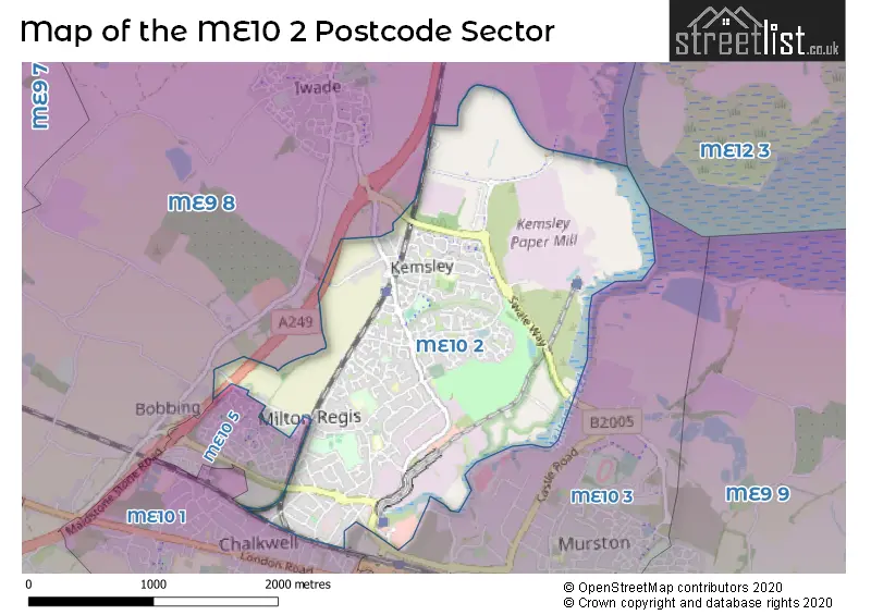
The largest settlement in the ME10 2 postal code is SITTINGBOURNE followed by Kemsley, and Milton Regis.
The ME10 2 Postcode shares a border with ME9 8 (Iwade, Borden, Bobbing), ME10 1 (SITTINGBOURNE, Tunstall), ME10 3 (SITTINGBOURNE, Murston) and ME10 5 (SITTINGBOURNE).
The sector is within the post town of SITTINGBOURNE.
ME10 2 is a postcode sector within the ME10 postcode district which is within the ME Medway postcode area.
The Royal Mail delivery office for the ME10 2 postal sector is the Sittingbourne Delivery Office.
The area of the ME10 2 postcode sector is 2.42 square miles which is 6.26 square kilometres or 1,546.84 square acres.
The ME10 2 postcode sector is crossed by the A249 Major A road.
Waterways within the ME10 2 postcode sector include the Milton Creek.

Map of the ME10 2 Postcode Sector
Explore the ME10 2 postcode sector by using our free interactive map.
| M | E | 1 | 0 | - | 2 | X | X |
| M | E | 1 | 0 | Space | 2 | Letter | Letter |
Official List of Streets
Kemsley (71 Streets)
SITTINGBOURNE (95 Streets)
Milton Regis (32 Streets)
Unofficial Streets or Alternative Spellings
Weather Forecast for ME10 2
Press Button to Show Forecast for Sittingbourne
| Time Period | Icon | Description | Temperature | Rain Probability | Wind |
|---|---|---|---|---|---|
| 12:00 to 15:00 | Sunny day | 21.0°C (feels like 18.0°C) | 0.00% | ENE 11 mph | |
| 15:00 to 18:00 | Sunny day | 20.0°C (feels like 17.0°C) | 0.00% | ENE 13 mph | |
| 18:00 to 21:00 | Sunny day | 16.0°C (feels like 15.0°C) | 0.00% | ENE 9 mph | |
| 21:00 to 00:00 | Partly cloudy (night) | 14.0°C (feels like 13.0°C) | 1.00% | ENE 7 mph |
Press Button to Show Forecast for Sittingbourne
| Time Period | Icon | Description | Temperature | Rain Probability | Wind |
|---|---|---|---|---|---|
| 00:00 to 03:00 | Cloudy | 15.0°C (feels like 14.0°C) | 4.00% | ENE 7 mph | |
| 03:00 to 06:00 | Cloudy | 14.0°C (feels like 13.0°C) | 4.00% | E 4 mph | |
| 06:00 to 09:00 | Cloudy | 15.0°C (feels like 15.0°C) | 4.00% | E 4 mph | |
| 09:00 to 12:00 | Cloudy | 21.0°C (feels like 19.0°C) | 3.00% | E 7 mph | |
| 12:00 to 15:00 | Partly cloudy (day) | 23.0°C (feels like 22.0°C) | 0.00% | ESE 9 mph | |
| 15:00 to 18:00 | Cloudy | 23.0°C (feels like 22.0°C) | 4.00% | ESE 9 mph | |
| 18:00 to 21:00 | Cloudy | 21.0°C (feels like 20.0°C) | 6.00% | SSE 7 mph | |
| 21:00 to 00:00 | Cloudy | 16.0°C (feels like 15.0°C) | 8.00% | SSW 7 mph |
Press Button to Show Forecast for Sittingbourne
| Time Period | Icon | Description | Temperature | Rain Probability | Wind |
|---|---|---|---|---|---|
| 00:00 to 03:00 | Cloudy | 14.0°C (feels like 14.0°C) | 9.00% | SSW 7 mph | |
| 03:00 to 06:00 | Overcast | 13.0°C (feels like 12.0°C) | 12.00% | SSW 7 mph | |
| 06:00 to 09:00 | Overcast | 13.0°C (feels like 12.0°C) | 14.00% | SSW 9 mph | |
| 09:00 to 12:00 | Cloudy | 16.0°C (feels like 14.0°C) | 11.00% | SSW 11 mph | |
| 12:00 to 15:00 | Overcast | 17.0°C (feels like 14.0°C) | 11.00% | S 13 mph | |
| 15:00 to 18:00 | Cloudy | 17.0°C (feels like 15.0°C) | 15.00% | S 13 mph | |
| 18:00 to 21:00 | Cloudy | 16.0°C (feels like 14.0°C) | 20.00% | SSE 11 mph | |
| 21:00 to 00:00 | Heavy rain | 15.0°C (feels like 13.0°C) | 75.00% | SSE 11 mph |
Press Button to Show Forecast for Sittingbourne
| Time Period | Icon | Description | Temperature | Rain Probability | Wind |
|---|---|---|---|---|---|
| 00:00 to 03:00 | Light rain | 14.0°C (feels like 13.0°C) | 56.00% | SSE 11 mph | |
| 03:00 to 06:00 | Light rain | 14.0°C (feels like 12.0°C) | 54.00% | SSE 9 mph | |
| 06:00 to 09:00 | Heavy rain | 13.0°C (feels like 12.0°C) | 80.00% | S 9 mph | |
| 09:00 to 12:00 | Light rain | 14.0°C (feels like 12.0°C) | 57.00% | S 11 mph | |
| 12:00 to 15:00 | Light rain | 16.0°C (feels like 13.0°C) | 50.00% | S 13 mph | |
| 15:00 to 18:00 | Cloudy | 17.0°C (feels like 14.0°C) | 15.00% | S 13 mph | |
| 18:00 to 21:00 | Cloudy | 16.0°C (feels like 14.0°C) | 10.00% | S 11 mph | |
| 21:00 to 00:00 | Partly cloudy (night) | 13.0°C (feels like 11.0°C) | 2.00% | SSE 9 mph |
Press Button to Show Forecast for Sittingbourne
| Time Period | Icon | Description | Temperature | Rain Probability | Wind |
|---|---|---|---|---|---|
| 00:00 to 03:00 | Partly cloudy (night) | 12.0°C (feels like 11.0°C) | 3.00% | S 9 mph | |
| 03:00 to 06:00 | Cloudy | 11.0°C (feels like 10.0°C) | 8.00% | S 9 mph | |
| 06:00 to 09:00 | Cloudy | 12.0°C (feels like 11.0°C) | 9.00% | S 9 mph | |
| 09:00 to 12:00 | Light rain shower (day) | 14.0°C (feels like 12.0°C) | 31.00% | S 13 mph | |
| 12:00 to 15:00 | Light rain shower (day) | 16.0°C (feels like 13.0°C) | 29.00% | S 13 mph | |
| 15:00 to 18:00 | Light rain shower (day) | 17.0°C (feels like 14.0°C) | 30.00% | S 13 mph | |
| 18:00 to 21:00 | Sunny day | 15.0°C (feels like 14.0°C) | 7.00% | S 9 mph | |
| 21:00 to 00:00 | Clear night | 12.0°C (feels like 11.0°C) | 1.00% | SSE 7 mph |
Schools and Places of Education Within the ME10 2 Postcode Sector
Kemsley Primary Academy
Academy sponsor led
Coldharbour Lane, Sittingbourne, Kent, ME10 2RP
Head: Iris Homer
Ofsted Rating: Good
Inspection: 2019-02-14 (1913 days ago)
Website: Visit Kemsley Primary Academy Website
Phone: 01795428689
Number of Pupils: 232
Milton Court Primary Academy
Academy sponsor led
Brewery Road, Sittingbourne, Kent, ME10 2EE
Head: Miss Sarah Gadsdon
Ofsted Rating: Good
Inspection: 2019-09-18 (1697 days ago)
Website: Visit Milton Court Primary Academy Website
Phone: 01795472972
Number of Pupils: 245
Regis Manor Primary School
Academy converter
North Street, Sittingbourne, Kent, ME10 2HW
Head: Mr Matthew Perry
Ofsted Rating: Good
Inspection: 2023-07-04 (312 days ago)
Website: Visit Regis Manor Primary School Website
Phone: 01795472971
Number of Pupils: 580
House Prices in the ME10 2 Postcode Sector
| Type of Property | 2018 Average | 2018 Sales | 2017 Average | 2017 Sales | 2016 Average | 2016 Sales | 2015 Average | 2015 Sales |
|---|---|---|---|---|---|---|---|---|
| Detached | £302,883 | 34 | £382,259 | 46 | £300,493 | 53 | £258,126 | 66 |
| Semi-Detached | £242,290 | 94 | £277,989 | 82 | £220,211 | 84 | £182,294 | 63 |
| Terraced | £217,934 | 121 | £235,252 | 110 | £188,914 | 115 | £160,165 | 99 |
| Flats | £138,538 | 26 | £143,698 | 25 | £128,764 | 31 | £108,190 | 29 |
Important Postcodes ME10 2 in the Postcode Sector
ME10 2EE is the postcode for Milton Court Childrens Centre, Brewery Road, HALL BLOCK, Milton Court Primary School, Brewery Road, and MAIN BUILDING, Milton Court Primary School, Brewery Road
ME10 2HA is the postcode for Swale Family Support Services, Green Porch House, Green Porch Close
ME10 2HE is the postcode for Orchards Centre, Attlee Way, and Swale MASH, Attlee Way
ME10 2HT is the postcode for Regis Manor Primary School, Middletune Avenue
ME10 2LP is the postcode for Youth Centre, Chalkwell Road, and New House Youth and Sports Centre, Chalkwell Road
ME10 2RP is the postcode for Kemsley Primary Academy, Coldharbour Lane, and Kemsley Primary Academy, Coldharbour Lane, Kemsley
| The ME10 2 Sector is within these Local Authorities |
|
|---|---|
| The ME10 2 Sector is within these Counties |
|
| The ME10 2 Sector is within these Water Company Areas |
|
Tourist Attractions within the ME10 2 Postcode Area
We found 1 visitor attractions within the ME10 postcode area
| Sittingbourne's Steam Railway |
|---|
| Railways |
| Steam / Heritage Railway |
| View Sittingbourne's Steam Railway on Google Maps |