The ME11 5 postcode sector is within the county of Kent.
Did you know? According to the 2021 Census, the ME11 5 postcode sector is home to a bustling 3,936 residents!
Given that each sector allows for 400 unique postcode combinations. Letters C, I, K, M, O and V are not allowed in the last two letters of a postcode. With 105 postcodes already in use, this leaves 295 units available.
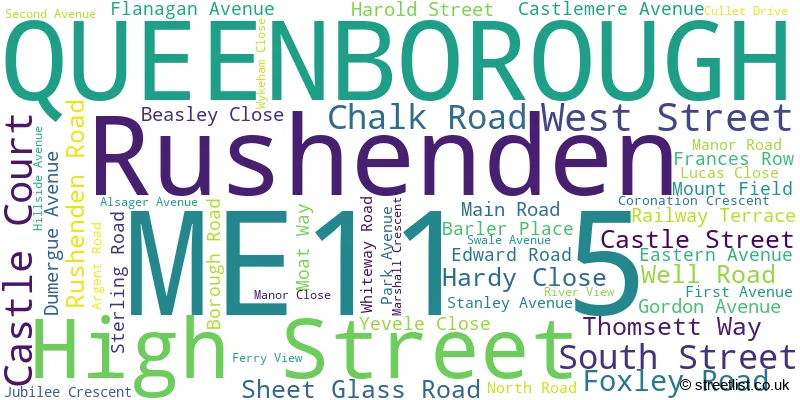
The largest settlements in the ME11 5 postal code are QUEENBOROUGH and Rushenden.
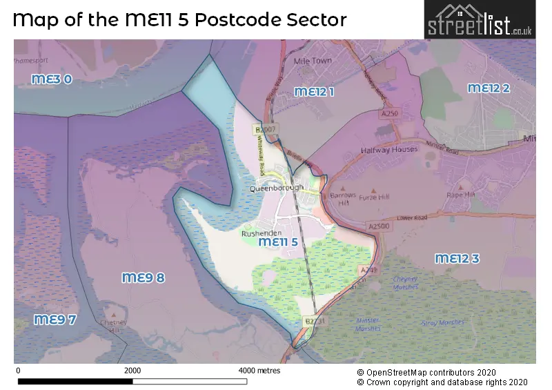
The ME11 5 Postcode shares a border with ME9 8 (Iwade, Borden, Bobbing), ME12 1 (SHEERNESS, Blue Town) and ME12 3 (Minster On Sea).
The sector is within the post town of QUEENBOROUGH.
ME11 5 is a postcode sector within the ME12 postcode district which is within the ME Medway postcode area.
The Royal Mail delivery office for the ME11 5 postal sector is the unknown.
The area of the ME11 5 postcode sector is 2.11 square miles which is 5.48 square kilometres or 1,353.55 square acres.
The ME11 5 postcode sector is crossed by the A249 Major A road.

Map of the ME11 5 Postcode Sector
Explore the ME11 5 postcode sector by using our free interactive map.
| M | E | 1 | 1 | - | 5 | X | X |
| M | E | 1 | 1 | Space | 5 | Letter | Letter |
Official List of Streets
QUEENBOROUGH (49 Streets)
Unofficial Streets or Alternative Spellings
SHEERNESS
BRIELLE WAY COURT HALL GEORGIAN CLOSE PARK ROAD SHEPPEY WAY SWALE CROSSING WEEKES COURTMinster On Sea
QUEENBOROUGH ROADWeather Forecast for ME11 5
Press Button to Show Forecast for Sheerness
| Time Period | Icon | Description | Temperature | Rain Probability | Wind |
|---|---|---|---|---|---|
| 09:00 to 12:00 | Cloudy | 14.0°C (feels like 12.0°C) | 6.00% | SSE 11 mph | |
| 12:00 to 15:00 | Cloudy | 15.0°C (feels like 13.0°C) | 10.00% | SSE 11 mph | |
| 15:00 to 18:00 | Cloudy | 15.0°C (feels like 13.0°C) | 10.00% | SSE 11 mph | |
| 18:00 to 21:00 | Cloudy | 14.0°C (feels like 13.0°C) | 17.00% | SE 7 mph | |
| 21:00 to 00:00 | Cloudy | 12.0°C (feels like 11.0°C) | 11.00% | SE 7 mph |
Press Button to Show Forecast for Sheerness
| Time Period | Icon | Description | Temperature | Rain Probability | Wind |
|---|---|---|---|---|---|
| 00:00 to 03:00 | Cloudy | 12.0°C (feels like 11.0°C) | 13.00% | SE 4 mph | |
| 03:00 to 06:00 | Cloudy | 11.0°C (feels like 10.0°C) | 12.00% | SSE 4 mph | |
| 06:00 to 09:00 | Cloudy | 11.0°C (feels like 11.0°C) | 12.00% | NNW 4 mph | |
| 09:00 to 12:00 | Cloudy | 13.0°C (feels like 12.0°C) | 12.00% | NNE 4 mph | |
| 12:00 to 15:00 | Cloudy | 14.0°C (feels like 13.0°C) | 15.00% | NNE 7 mph | |
| 15:00 to 18:00 | Cloudy | 15.0°C (feels like 13.0°C) | 10.00% | NNE 9 mph | |
| 18:00 to 21:00 | Cloudy | 14.0°C (feels like 13.0°C) | 11.00% | NE 9 mph | |
| 21:00 to 00:00 | Cloudy | 13.0°C (feels like 11.0°C) | 8.00% | N 11 mph |
Press Button to Show Forecast for Sheerness
| Time Period | Icon | Description | Temperature | Rain Probability | Wind |
|---|---|---|---|---|---|
| 00:00 to 03:00 | Light rain shower (night) | 12.0°C (feels like 10.0°C) | 30.00% | WNW 11 mph | |
| 03:00 to 06:00 | Cloudy | 11.0°C (feels like 9.0°C) | 11.00% | NW 11 mph | |
| 06:00 to 09:00 | Partly cloudy (day) | 12.0°C (feels like 10.0°C) | 11.00% | NW 11 mph | |
| 09:00 to 12:00 | Cloudy | 13.0°C (feels like 12.0°C) | 9.00% | NW 11 mph | |
| 12:00 to 15:00 | Partly cloudy (day) | 15.0°C (feels like 13.0°C) | 6.00% | NNW 11 mph | |
| 15:00 to 18:00 | Partly cloudy (day) | 16.0°C (feels like 14.0°C) | 5.00% | NNW 11 mph | |
| 18:00 to 21:00 | Sunny day | 15.0°C (feels like 13.0°C) | 4.00% | NNW 11 mph | |
| 21:00 to 00:00 | Partly cloudy (night) | 13.0°C (feels like 11.0°C) | 4.00% | NW 11 mph |
Schools and Places of Education Within the ME11 5 Postcode Sector
Queenborough School and Nursery
Academy converter
Edward Road, Queenborough, Kent, ME11 5DF
Head: Mr Jason Howard
Ofsted Rating: Outstanding
Inspection: 2023-07-04 (301 days ago)
Website: Visit Queenborough School and Nursery Website
Phone: 01795662574
Number of Pupils: 470
House Prices in the ME11 5 Postcode Sector
| Type of Property | 2018 Average | 2018 Sales | 2017 Average | 2017 Sales | 2016 Average | 2016 Sales | 2015 Average | 2015 Sales |
|---|---|---|---|---|---|---|---|---|
| Detached | £251,997 | 7 | £190,000 | 1 | £175,000 | 1 | £177,667 | 3 |
| Semi-Detached | £228,320 | 42 | £192,800 | 10 | £178,433 | 15 | £156,940 | 18 |
| Terraced | £187,101 | 42 | £174,434 | 39 | £157,645 | 31 | £132,755 | 42 |
| Flats | £84,360 | 11 | £103,417 | 6 | £102,125 | 4 | £85,000 | 5 |
Important Postcodes ME11 5 in the Postcode Sector
ME11 5DF is the postcode for NEW CLASSROOM, Queenborough School & Nursery, Edward Road, Queenborough School & Nursery, Edward Road, and Queenborough Cp School, Edward Road
| The ME11 5 Sector is within these Local Authorities |
|
|---|---|
| The ME11 5 Sector is within these Counties |
|
| The ME11 5 Sector is within these Water Company Areas |
|