The ME15 postcode district is a postal district located in the ME Medway postcode area with a population of 53,310 residents according to the 2021 England and Wales Census.
The area of the ME15 postcode district is 14.26 square miles which is 36.93 square kilometres or 9,125.29 acres.
Currently, the ME15 district has about 1360 postcode units spread across 5 geographic postcode sectors.
Given that each sector allows for 400 unique postcode combinations, the district has a capacity of 2,000 postcodes. With 1360 postcodes already in use, this leaves 640 units available.
The largest settlement in the ME15 postal code is MAIDSTONE followed by Bearsted, and Loose.
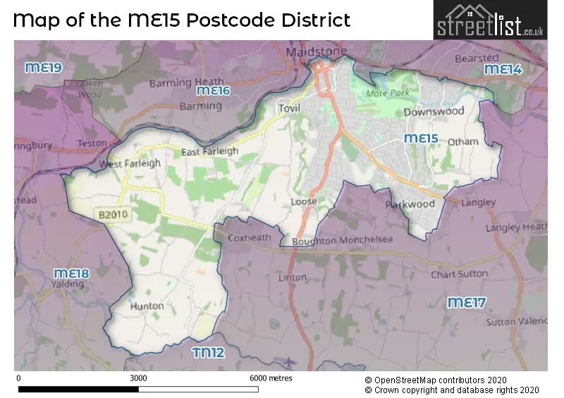
The ME15 Postcode shares a border with ME17 (Coxheath, Harrietsham, Lenham), ME14 (MAIDSTONE, Bearsted, Weavering), ME16 (MAIDSTONE, Allington, Barming), ME18 (Wateringbury, Yalding, Mereworth) and TN12 (Paddock Wood, Staplehurst, Marden).
In the ME15 postcode district, the primary settlement is Maidstone, which is located in Kent, England. Other significant settlements in this district include East Farleigh, Hunton, Loose, West Farleigh, Chequers Centre, Tovil, Bearsted, Downswood, and Otham. The most significant post town is Maidstone.
For the district ME15, we have data on 5 postcode sectors. Here's a breakdown: The sector ME15 0, covers East Farleigh and Loose and Hunton and West Farleigh in Kent. The sector ME15 6, covers Maidstone and Tovil in Kent. The sector ME15 7, covers Maidstone in Kent. The sector ME15 8, covers Maidstone and Bearsted and Otham in Kent. The sector ME15 9, covers Maidstone in Kent.


Map of the ME15 Postcode District
Explore the ME15 postcode district by using our free interactive map.
When it comes to local government, postal geography often disregards political borders. However, for a breakdown in the ME15 District: the district mostly encompasses the Maidstone District (B) area with a total of 1368 postcodes.
Recent House Sales in ME15
| Date | Price | Address |
|---|---|---|
| 18/10/2023 | £580,000 | Mote Avenue, Maidstone, ME15 7ST |
| 12/10/2023 | £400,000 | Chapman Avenue, Maidstone, ME15 8EN |
| 29/09/2023 | £447,000 | Lancet Lane, Maidstone, ME15 9SD |
| 25/09/2023 | £385,000 | Anglesey Avenue, Maidstone, ME15 9SH |
| 21/09/2023 | £123,000 | Longham Copse, Downswood, Maidstone, ME15 8TL |
| 20/09/2023 | £600,000 | Button Lane, Bearsted, Maidstone, ME15 8DW |
| 14/09/2023 | £300,000 | Elm Grove, Maidstone, ME15 7RT |
| 12/09/2023 | £340,000 | Brook Cottages, East Farleigh, Maidstone, ME15 0HL |
| 08/09/2023 | £405,500 | Rainham Close, Maidstone, ME15 6UQ |
| 08/09/2023 | £575,000 | Park Way, Maidstone, ME15 7DL |
Weather Forecast for ME15
Press Button to Show Forecast for East Malling
| Time Period | Icon | Description | Temperature | Rain Probability | Wind |
|---|---|---|---|---|---|
| 06:00 to 09:00 | Light rain | 7.0°C (feels like 5.0°C) | 78.00% | NE 4 mph | |
| 09:00 to 12:00 | Overcast | 9.0°C (feels like 7.0°C) | 15.00% | ENE 7 mph | |
| 12:00 to 15:00 | Cloudy | 12.0°C (feels like 11.0°C) | 39.00% | ENE 9 mph | |
| 15:00 to 18:00 | Cloudy | 13.0°C (feels like 11.0°C) | 16.00% | NE 9 mph | |
| 18:00 to 21:00 | Light rain | 11.0°C (feels like 9.0°C) | 59.00% | NE 9 mph | |
| 21:00 to 00:00 | Heavy rain | 10.0°C (feels like 8.0°C) | 92.00% | NE 7 mph |
Press Button to Show Forecast for East Malling
| Time Period | Icon | Description | Temperature | Rain Probability | Wind |
|---|---|---|---|---|---|
| 00:00 to 03:00 | Heavy rain | 10.0°C (feels like 8.0°C) | 93.00% | NE 7 mph | |
| 03:00 to 06:00 | Heavy rain | 10.0°C (feels like 8.0°C) | 80.00% | ESE 7 mph | |
| 06:00 to 09:00 | Light rain | 10.0°C (feels like 8.0°C) | 50.00% | S 7 mph | |
| 09:00 to 12:00 | Light rain | 11.0°C (feels like 9.0°C) | 52.00% | SW 9 mph | |
| 12:00 to 15:00 | Light rain shower (day) | 11.0°C (feels like 8.0°C) | 41.00% | W 13 mph | |
| 15:00 to 18:00 | Cloudy | 11.0°C (feels like 8.0°C) | 14.00% | W 11 mph | |
| 18:00 to 21:00 | Cloudy | 11.0°C (feels like 9.0°C) | 8.00% | WSW 9 mph | |
| 21:00 to 00:00 | Clear night | 8.0°C (feels like 6.0°C) | 2.00% | SW 7 mph |
Press Button to Show Forecast for East Malling
| Time Period | Icon | Description | Temperature | Rain Probability | Wind |
|---|---|---|---|---|---|
| 00:00 to 03:00 | Clear night | 7.0°C (feels like 5.0°C) | 1.00% | SW 4 mph | |
| 03:00 to 06:00 | Clear night | 6.0°C (feels like 4.0°C) | 1.00% | SSW 2 mph | |
| 06:00 to 09:00 | Sunny day | 7.0°C (feels like 6.0°C) | 1.00% | S 4 mph | |
| 09:00 to 12:00 | Cloudy | 12.0°C (feels like 10.0°C) | 4.00% | S 9 mph | |
| 12:00 to 15:00 | Partly cloudy (day) | 15.0°C (feels like 12.0°C) | 2.00% | S 11 mph | |
| 15:00 to 18:00 | Partly cloudy (day) | 15.0°C (feels like 13.0°C) | 2.00% | S 11 mph | |
| 18:00 to 21:00 | Sunny day | 14.0°C (feels like 12.0°C) | 3.00% | S 7 mph | |
| 21:00 to 00:00 | Clear night | 9.0°C (feels like 8.0°C) | 1.00% | SE 4 mph |
Press Button to Show Forecast for East Malling
| Time Period | Icon | Description | Temperature | Rain Probability | Wind |
|---|---|---|---|---|---|
| 00:00 to 03:00 | Partly cloudy (night) | 9.0°C (feels like 7.0°C) | 2.00% | SE 4 mph | |
| 03:00 to 06:00 | Partly cloudy (night) | 8.0°C (feels like 7.0°C) | 3.00% | SE 4 mph | |
| 06:00 to 09:00 | Cloudy | 9.0°C (feels like 8.0°C) | 8.00% | SE 4 mph | |
| 09:00 to 12:00 | Cloudy | 13.0°C (feels like 12.0°C) | 6.00% | SE 7 mph | |
| 12:00 to 15:00 | Cloudy | 16.0°C (feels like 14.0°C) | 10.00% | SE 9 mph | |
| 15:00 to 18:00 | Cloudy | 16.0°C (feels like 15.0°C) | 9.00% | SE 9 mph | |
| 18:00 to 21:00 | Cloudy | 15.0°C (feels like 14.0°C) | 20.00% | ESE 7 mph | |
| 21:00 to 00:00 | Cloudy | 12.0°C (feels like 11.0°C) | 18.00% | ESE 4 mph |
Where is the ME15 Postcode District?
The postcode district ME15 is located in Maidstone, a town in Kent. Maidstone is surrounded by several nearby towns, including Aylesford to the north, West Malling to the northwest, Cranbrook to the south, and Tonbridge to the west. Additionally, the distance from Maidstone to the center of London is approximately 32.88 miles.
The district is within the post town of MAIDSTONE.
The sector has postcodes within the nation of England.
The ME15 Postcode District is in the Mid Kent region of Kent within the South East (England).
| Postcode Sector | Delivery Office |
|---|---|
| ME15 0 | Maidstone Delivery Office |
| ME15 6 | Maidstone Delivery Office |
| ME15 7 | Maidstone Delivery Office |
| ME15 8 | Maidstone Delivery Office |
| ME15 9 | Maidstone Delivery Office |
| M | E | 1 | 5 | - | X | X | X |
| M | E | 1 | 5 | Space | Numeric | Letter | Letter |
Current Monthly Rental Prices
| # Bedrooms | Min Price | Max Price | Avg Price |
|---|---|---|---|
| £825 | £825 | £825 | |
| 1 | £600 | £1,200 | £946 |
| 2 | £1,100 | £1,300 | £1,250 |
| 3 | £1,300 | £1,750 | £1,583 |
| 4 | £1,700 | £2,200 | £1,967 |
Current House Prices
| # Bedrooms | Min Price | Max Price | Avg Price |
|---|---|---|---|
| £15,000 | £565,000 | £215,455 | |
| 1 | £106,000 | £350,000 | £202,214 |
| 2 | £120,000 | £425,000 | £256,935 |
| 3 | £170,000 | £1,000,000 | £415,391 |
| 4 | £280,500 | £1,200,000 | £592,835 |
| 5 | £315,000 | £1,299,950 | £774,541 |
| 6 | £850,000 | £1,750,000 | £1,448,333 |
| 7 | £575,000 | £1,550,000 | £1,140,000 |
| 8 | £9,200,000 | £9,200,000 | £9,200,000 |
Estate Agents who Operate in the ME15 District
| Logo | Name | Brand Name | Address | Contact Number | Total Properties |
|---|---|---|---|---|---|
 | Loose | Wards | Loose Green, Loose, Maidstone, Kent, ME15 0AA | 01622 233332 | 25 |
 | Maidstone | Knight Edmonds | 20-22 King Street, Maidstone, ME14 1DE | 01622 943499 | 19 |
 | Maidstone | Wards | 79 King Street, Maidstone, Kent, ME14 1BG | 01622 943960 | 19 |
 | Worthing | Homewise | 1 Liverpool Gardens Worthing BN11 1TF | 01903 497338 | 19 |
 | Maidstone | Your Move | 24 King Street, Maidstone, ME14 1DW | 01622 232975 | 19 |
| Type of Property | 2018 Average | 2018 Sales | 2017 Average | 2017 Sales | 2016 Average | 2016 Sales | 2015 Average | 2015 Sales |
|---|---|---|---|---|---|---|---|---|
| Detached | £494,811 | 104 | £459,492 | 172 | £424,435 | 154 | £387,481 | 147 |
| Semi-Detached | £314,564 | 269 | £291,912 | 305 | £287,232 | 291 | £258,060 | 262 |
| Terraced | £255,494 | 263 | £255,015 | 338 | £233,379 | 257 | £207,229 | 294 |
| Flats | £185,278 | 103 | £172,826 | 164 | £173,914 | 296 | £185,091 | 128 |