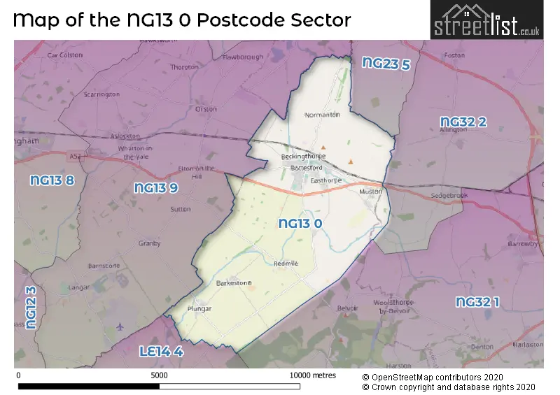
The NG13 0 postcode sector lies where the three counties of Leicestershire, Lincolnshire, and Nottinghamshire meet.
Did you know? According to the 2021 Census, the NG13 0 postcode sector is home to a bustling 4,629 residents!
Given that each sector allows for 400 unique postcode combinations. Letters C, I, K, M, O and V are not allowed in the last two letters of a postcode. With 149 postcodes already in use, this leaves 251 units available.
The largest settlement in the NG13 0 postal code is Bottesford followed by Redmile, and Barkestone.
The NG13 0 Postcode shares a border with LE14 4 (Long Clawson, Waltham On The Wolds, Harby), NG13 9 (Whatton, Aslockton, Langar), NG23 5 (Long Bennington, Claypole, Elston), NG32 1 (Barrowby, Harlaxton, Croxton Kerrial) and NG32 2 (Allington, Barkston, Foston).
The sector is within the post town of NOTTINGHAM.
NG13 0 is a postcode sector within the NG13 postcode district which is within the NG Nottingham postcode area.
The Royal Mail delivery office for the NG13 0 postal sector is the Barkstone Scale Payment Delivery Office and Bottesford Scale Payment Delivery Office and Redmile Scale Payment Delivery Office.
The area of the NG13 0 postcode sector is 16.98 square miles which is 43.98 square kilometres or 10,868.91 square acres.
The NG13 0 postcode sector is crossed by the A52 Major A road.
Waterways within the NG13 0 postcode sector include the Grantham Canal, River Whipling, The Grimmer, River Devon, Moor Dyke.

Map of the NG13 0 Postcode Sector
Explore the NG13 0 postcode sector by using our free interactive map.
| N | G | 1 | 3 | - | 0 | X | X |
| N | G | 1 | 3 | Space | 0 | Letter | Letter |
Official List of Streets
Bottesford (84 Streets)
Redmile (11 Streets)
Plungar (9 Streets)
Easthorpe (4 Streets)
Barkestone (13 Streets)
Unofficial Streets or Alternative Spellings
Belvoir
WOOLSTHORPE ROADStathern
LONG LANEOrston
BOTTESFORD LANEAlverton
LONGHEDGE LANEWeather Forecast for NG13 0
Press Button to Show Forecast for Bottesford
| Time Period | Icon | Description | Temperature | Rain Probability | Wind |
|---|---|---|---|---|---|
| 09:00 to 12:00 | Partly cloudy (day) | 7.0°C (feels like 6.0°C) | 1.00% | NNE 4 mph | |
| 12:00 to 15:00 | Cloudy | 9.0°C (feels like 8.0°C) | 10.00% | NE 7 mph | |
| 15:00 to 18:00 | Cloudy | 9.0°C (feels like 8.0°C) | 10.00% | NE 4 mph | |
| 18:00 to 21:00 | Cloudy | 8.0°C (feels like 6.0°C) | 11.00% | ENE 4 mph | |
| 21:00 to 00:00 | Cloudy | 5.0°C (feels like 3.0°C) | 10.00% | ENE 4 mph |
Press Button to Show Forecast for Bottesford
| Time Period | Icon | Description | Temperature | Rain Probability | Wind |
|---|---|---|---|---|---|
| 00:00 to 03:00 | Cloudy | 4.0°C (feels like 2.0°C) | 9.00% | ENE 4 mph | |
| 03:00 to 06:00 | Cloudy | 3.0°C (feels like 1.0°C) | 11.00% | NE 4 mph | |
| 06:00 to 09:00 | Cloudy | 4.0°C (feels like 2.0°C) | 10.00% | NE 7 mph | |
| 09:00 to 12:00 | Cloudy | 8.0°C (feels like 6.0°C) | 13.00% | ENE 9 mph | |
| 12:00 to 15:00 | Overcast | 10.0°C (feels like 8.0°C) | 21.00% | ENE 9 mph | |
| 15:00 to 18:00 | Overcast | 11.0°C (feels like 8.0°C) | 21.00% | ENE 11 mph | |
| 18:00 to 21:00 | Cloudy | 9.0°C (feels like 7.0°C) | 14.00% | ENE 11 mph | |
| 21:00 to 00:00 | Cloudy | 7.0°C (feels like 4.0°C) | 16.00% | NE 9 mph |
Press Button to Show Forecast for Bottesford
| Time Period | Icon | Description | Temperature | Rain Probability | Wind |
|---|---|---|---|---|---|
| 00:00 to 03:00 | Cloudy | 7.0°C (feels like 4.0°C) | 20.00% | NE 11 mph | |
| 03:00 to 06:00 | Heavy rain | 7.0°C (feels like 4.0°C) | 75.00% | NE 11 mph | |
| 06:00 to 09:00 | Heavy rain | 8.0°C (feels like 5.0°C) | 78.00% | NE 11 mph | |
| 09:00 to 12:00 | Heavy rain | 10.0°C (feels like 7.0°C) | 76.00% | ENE 11 mph | |
| 12:00 to 15:00 | Heavy rain shower (day) | 11.0°C (feels like 8.0°C) | 58.00% | NNE 11 mph | |
| 15:00 to 18:00 | Heavy rain shower (day) | 11.0°C (feels like 8.0°C) | 61.00% | W 11 mph | |
| 18:00 to 21:00 | Light rain shower (day) | 10.0°C (feels like 7.0°C) | 36.00% | NNE 9 mph | |
| 21:00 to 00:00 | Cloudy | 8.0°C (feels like 6.0°C) | 11.00% | SSE 7 mph |
Schools and Places of Education Within the NG13 0 Postcode Sector
Bottesford Church of England Primary School
Academy converter
Silverwood Road, Nottingham, Nottinghamshire, NG13 0BS
Head: Mrs Emma Barker
Ofsted Rating: Good
Inspection: 2023-11-01 (177 days ago)
Website: Visit Bottesford Church of England Primary School Website
Phone: 01949842224
Number of Pupils: 235
Redmile Church of England Primary School
Academy converter
Belvoir Road, Nottingham, Nottinghamshire, NG13 0GL
Head: Mrs ALISON LONGDEN
Ofsted Rating: Good
Inspection: 2019-03-27 (1857 days ago)
Website: Visit Redmile Church of England Primary School Website
Phone: 01949842429
Number of Pupils: 71
The Place Independent School
Other independent special school
Hill Farm, , , NG13 0EA
Head: Ms Charlotte Hardy
Ofsted Rating: Good
Inspection: 2021-11-25 (883 days ago)
Website: Visit The Place Independent School Website
Phone: 01949844440
Number of Pupils: 31
The Priory Belvoir Academy
Academy converter
Barkestone Lane, Nottingham, Nottinghamshire, NG13 0AX
Head: Mr Levon Newton
Ofsted Rating: Good
Inspection: 2018-06-19 (2138 days ago)
Website: Visit The Priory Belvoir Academy Website
Phone: 01949844920
Number of Pupils: 688
House Prices in the NG13 0 Postcode Sector
| Type of Property | 2018 Average | 2018 Sales | 2017 Average | 2017 Sales | 2016 Average | 2016 Sales | 2015 Average | 2015 Sales |
|---|---|---|---|---|---|---|---|---|
| Detached | £356,623 | 40 | £336,108 | 49 | £299,973 | 58 | £335,213 | 52 |
| Semi-Detached | £224,932 | 22 | £246,658 | 19 | £218,151 | 26 | £178,279 | 19 |
| Terraced | £198,833 | 9 | £158,008 | 9 | £184,945 | 11 | £183,944 | 18 |
| Flats | £124,950 | 1 | £130,000 | 2 | £0 | 0 | £0 | 0 |
Important Postcodes NG13 0 in the Postcode Sector
NG13 0AX is the postcode for DEBDALE, Belvoir High School & Community Centre, Barkestone Lane, The Priory Belvoir Academy, Barkestone Lane, NEW SCIENCE BLOCK, Belvoir High School & Community Centre, Barkestone Lane, Main Building, Priory Belvoir Academy, Barkestone Lane, NEW SCIENCE BLOCK, The Priory Belvoir Academy, Barkestone Lane, Science Block, Priory Belvoir Academy, Barkestone Lane, THE PRIORY BELVOIR ACADEMY, BARKESTONE LANE, BOTTESFORD, and BLOCKS A, B, E, Belvoir High School & Community Centre, Barkestone Lane
NG13 0BS is the postcode for Bottesford C of E Primary School, Silverwood Road, Bottesford, BLOCK A,B, Bottesford C of E Primary School, Silverwood Road, and Bottesford C of E Primary School, Silverwood Road
NG13 0GL is the postcode for SCHOOL HALL NEW BUILD, Redmile Primary School, 6 Belvoir Road, and Redmile Primary School, 6 Belvoir Road
| The NG13 0 Sector is within these Local Authorities |
|
|---|---|
| The NG13 0 Sector is within these Counties |
|
| The NG13 0 Sector is within these Water Company Areas |
|