The NG2 1 postcode sector is within the county of Nottinghamshire.
Did you know? According to the 2021 Census, the NG2 1 postcode sector is home to a bustling 2,619 residents!
Given that each sector allows for 400 unique postcode combinations. Letters C, I, K, M, O and V are not allowed in the last two letters of a postcode. With 94 postcodes already in use, this leaves 306 units available.
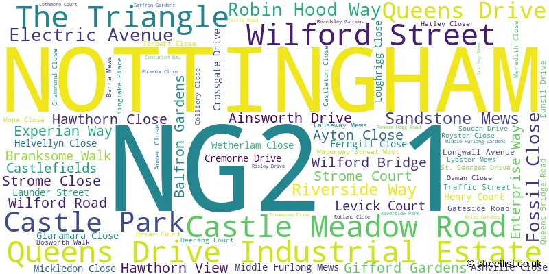
The largest settlements in the NG2 1 postal code are NOTTINGHAM and Queens Drive Industrial Estate.
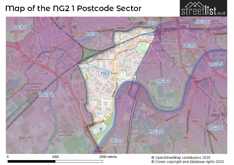
The NG2 1 Postcode shares a border with NG1 7 (NOTTINGHAM), NG2 2 (NOTTINGHAM), NG2 3 (NOTTINGHAM), NG7 1 (NOTTINGHAM, The Park), NG7 2 (NOTTINGHAM, Lenton, Lenton Lane Industrial Estate), NG11 7 (NOTTINGHAM, Wilford) and NG11 8 (NOTTINGHAM, Clifton Village, Clifton).
The sector is within the post town of NOTTINGHAM.
NG2 1 is a postcode sector within the NG2 postcode district which is within the NG Nottingham postcode area.
The Royal Mail delivery office for the NG2 1 postal sector is the Nottingham South Delivery Office.
The area of the NG2 1 postcode sector is 0.71 square miles which is 1.84 square kilometres or 454.17 square acres.
The NG2 1 postcode sector is crossed by the A52 Major A road.
Waterways within the NG2 1 postcode sector include the Tinkers Leen, River Leen, Tottle Brook, Nottingham Canal; Beeston Canal, River Trent.

Map of the NG2 1 Postcode Sector
Explore the NG2 1 postcode sector by using our free interactive map.
| N | G | 2 | - | 1 | X | X |
| N | G | 2 | Space | 1 | Letter | Letter |
Official List of Streets
NOTTINGHAM (68 Streets)
Queens Drive Industrial Estate (5 Streets)
Unofficial Streets or Alternative Spellings
NOTTINGHAM
CARRINGTON STREET CARROLL GARDENS CASTLE BOULEVARD CASTLE BRIDGE ROAD CASTLE ROAD CLIFTON BOULEVARD CROCUS STREET DEERING COURT LEVICK COURT MEADOWS WAY STATION STREET STROME COURT SWEET LEYS ROAD VICTORIA EMBANKMENT ALDER COURT BIRDCAGE WALK BURNHAM WAY HAWTHORN COURT KIRKE WHITE WAY LINKMEL CLOSE QUEENS GROVE QUEENS WALK SAINT GEORGES DRIVE SHERIFFS WAY THE BIG TRACK / NOTTINGHAM CANAL TOWPATH TINKERS WAY WOODLAND WALKWilford
MAIN ROADWeather Forecast for NG2 1
Press Button to Show Forecast for Wilford
| Time Period | Icon | Description | Temperature | Rain Probability | Wind |
|---|---|---|---|---|---|
| 03:00 to 06:00 | Partly cloudy (night) | 5.0°C (feels like 3.0°C) | 2.00% | NE 7 mph | |
| 06:00 to 09:00 | Cloudy | 5.0°C (feels like 2.0°C) | 5.00% | NE 7 mph | |
| 09:00 to 12:00 | Cloudy | 8.0°C (feels like 6.0°C) | 14.00% | ENE 11 mph | |
| 12:00 to 15:00 | Overcast | 10.0°C (feels like 7.0°C) | 18.00% | ENE 9 mph | |
| 15:00 to 18:00 | Overcast | 9.0°C (feels like 7.0°C) | 13.00% | ENE 11 mph | |
| 18:00 to 21:00 | Overcast | 9.0°C (feels like 6.0°C) | 12.00% | NE 11 mph | |
| 21:00 to 00:00 | Overcast | 7.0°C (feels like 4.0°C) | 11.00% | NE 11 mph |
Press Button to Show Forecast for Wilford
| Time Period | Icon | Description | Temperature | Rain Probability | Wind |
|---|---|---|---|---|---|
| 00:00 to 03:00 | Overcast | 7.0°C (feels like 3.0°C) | 11.00% | NNE 11 mph | |
| 03:00 to 06:00 | Heavy rain | 6.0°C (feels like 3.0°C) | 78.00% | N 13 mph | |
| 06:00 to 09:00 | Heavy rain | 6.0°C (feels like 2.0°C) | 83.00% | N 13 mph | |
| 09:00 to 12:00 | Heavy rain | 7.0°C (feels like 3.0°C) | 83.00% | NNW 13 mph | |
| 12:00 to 15:00 | Light rain | 8.0°C (feels like 5.0°C) | 47.00% | NW 11 mph | |
| 15:00 to 18:00 | Cloudy | 10.0°C (feels like 8.0°C) | 15.00% | WNW 9 mph | |
| 18:00 to 21:00 | Partly cloudy (day) | 10.0°C (feels like 8.0°C) | 6.00% | W 9 mph | |
| 21:00 to 00:00 | Clear night | 8.0°C (feels like 6.0°C) | 3.00% | SW 7 mph |
Press Button to Show Forecast for Wilford
| Time Period | Icon | Description | Temperature | Rain Probability | Wind |
|---|---|---|---|---|---|
| 00:00 to 03:00 | Clear night | 6.0°C (feels like 4.0°C) | 1.00% | SW 4 mph | |
| 03:00 to 06:00 | Clear night | 5.0°C (feels like 3.0°C) | 0.00% | SSW 4 mph | |
| 06:00 to 09:00 | Sunny day | 5.0°C (feels like 3.0°C) | 1.00% | S 7 mph | |
| 09:00 to 12:00 | Sunny day | 11.0°C (feels like 8.0°C) | 1.00% | S 11 mph | |
| 12:00 to 15:00 | Cloudy | 14.0°C (feels like 11.0°C) | 5.00% | S 13 mph | |
| 15:00 to 18:00 | Cloudy | 15.0°C (feels like 12.0°C) | 6.00% | S 13 mph | |
| 18:00 to 21:00 | Partly cloudy (day) | 14.0°C (feels like 12.0°C) | 3.00% | S 11 mph | |
| 21:00 to 00:00 | Clear night | 11.0°C (feels like 9.0°C) | 2.00% | SSE 9 mph |
Press Button to Show Forecast for Wilford
| Time Period | Icon | Description | Temperature | Rain Probability | Wind |
|---|---|---|---|---|---|
| 00:00 to 03:00 | Clear night | 9.0°C (feels like 7.0°C) | 2.00% | SE 7 mph | |
| 03:00 to 06:00 | Clear night | 7.0°C (feels like 6.0°C) | 2.00% | ESE 7 mph | |
| 06:00 to 09:00 | Sunny day | 8.0°C (feels like 6.0°C) | 3.00% | ESE 7 mph | |
| 09:00 to 12:00 | Partly cloudy (day) | 12.0°C (feels like 10.0°C) | 4.00% | ESE 9 mph | |
| 12:00 to 15:00 | Partly cloudy (day) | 16.0°C (feels like 14.0°C) | 5.00% | SE 11 mph | |
| 15:00 to 18:00 | Cloudy | 17.0°C (feels like 14.0°C) | 10.00% | ESE 11 mph | |
| 18:00 to 21:00 | Cloudy | 15.0°C (feels like 13.0°C) | 8.00% | ESE 9 mph | |
| 21:00 to 00:00 | Cloudy | 12.0°C (feels like 11.0°C) | 12.00% | E 9 mph |
Schools and Places of Education Within the NG2 1 Postcode Sector
CP Riverside School
Free schools alternative provision
Riverside Way, Nottingham, , NG2 1DP
Head: Mr Mark Eyre
Ofsted Rating: Good
Inspection: 2022-04-22 (736 days ago)
Website: Visit CP Riverside School Website
Phone: 01159864098
Number of Pupils: 5
Victoria Primary School
Academy converter
Ainsworth Drive, Nottingham, Nottinghamshire, NG2 1FX
Head: Miss Anna Froggatt
Ofsted Rating: Good
Inspection: 2019-06-26 (1767 days ago)
Website: Visit Victoria Primary School Website
Phone: 01158077750
Number of Pupils: 330
Welbeck Primary School
Community school
Kinglake Place, Nottingham, Nottinghamshire, NG2 1NT
Head: Mrs Rebecca Gittins
Ofsted Rating: Good
Inspection: 2022-03-02 (787 days ago)
Website: Visit Welbeck Primary School Website
Phone: 01159153890
Number of Pupils: 360
House Prices in the NG2 1 Postcode Sector
| Type of Property | 2018 Average | 2018 Sales | 2017 Average | 2017 Sales | 2016 Average | 2016 Sales | 2015 Average | 2015 Sales |
|---|---|---|---|---|---|---|---|---|
| Detached | £0 | 0 | £0 | 0 | £0 | 0 | £85,000 | 1 |
| Semi-Detached | £102,667 | 3 | £98,083 | 6 | £121,667 | 3 | £92,667 | 3 |
| Terraced | £116,679 | 14 | £106,315 | 17 | £93,774 | 19 | £85,344 | 16 |
| Flats | £108,500 | 1 | £70,833 | 3 | £57,167 | 3 | £58,500 | 2 |
Important Postcodes NG2 1 in the Postcode Sector
NG2 1AB is the postcode for Valuation Office Agency, Ferrers House, Castle Meadow Road
NG2 1AG is the postcode for HM Revenue & Customs, Barkley House, HM Revenue & Customs, Mowbray House, HM Revenue & Customs, Howard House, HM Revenue & Customs, Ferrers House, HM Revenue & Customs, Fitzroy House, HM Revenue & Customs, Amenity Building, ARCHIVES BUILDING, Nottinghamshire County Council, County House, Castle Meadow Road, and HM Revenue & Customs, Yorke House
NG2 1AH is the postcode for VIA East Midlands, QueenG��s Drive-Unit 7
NG2 1AW is the postcode for HMRC, 1 Unity Square
NG2 1DP is the postcode for CP Riverside School, Riverside Way
NG2 1DS is the postcode for Nottinghamshire County Council, Riverside Way
NG2 1EE is the postcode for BRIDEWELL CUSTODY SUITE, Nottingham Magistrates Court, Wilford Street, Nottingham Magistrates Court, Carrington Street, and Bridewell 2 Police Station, Carrington Street
NG2 1FX is the postcode for NEW BLOCK, Victoria Primary School, Ainsworth Drive, and Victoria Primary School, Ainsworth Drive
NG2 1NA is the postcode for Newcastle College Construction Academy Phase 1, Linkmel Close, and Newcastle College Construction Academy Phase 2, Linkmel Close
NG2 1NT is the postcode for FOUNDATION UNIT, Welbeck School, Kinglake Place, Welbeck School, Kinglake Place, and WELBECK PRIMARY SCHOOL, KINGLAKE PLACE
NG2 1PW is the postcode for Nottinghamshire Police, Meadows Section Police Station, Crammond Close
NG2 1RX is the postcode for Nottinghamshire Police, Rennie Hogg Road
| The NG2 1 Sector is within these Local Authorities |
|
|---|---|
| The NG2 1 Sector is within these Counties |
|
| The NG2 1 Sector is within these Water Company Areas |
|