The NG3 3 postcode sector is within the county of Nottinghamshire.
Did you know? According to the 2021 Census, the NG3 3 postcode sector is home to a bustling 8,294 residents!
Given that each sector allows for 400 unique postcode combinations. Letters C, I, K, M, O and V are not allowed in the last two letters of a postcode. With 127 postcodes already in use, this leaves 273 units available.
The NG3 3 postal code covers the settlement of NOTTINGHAM.
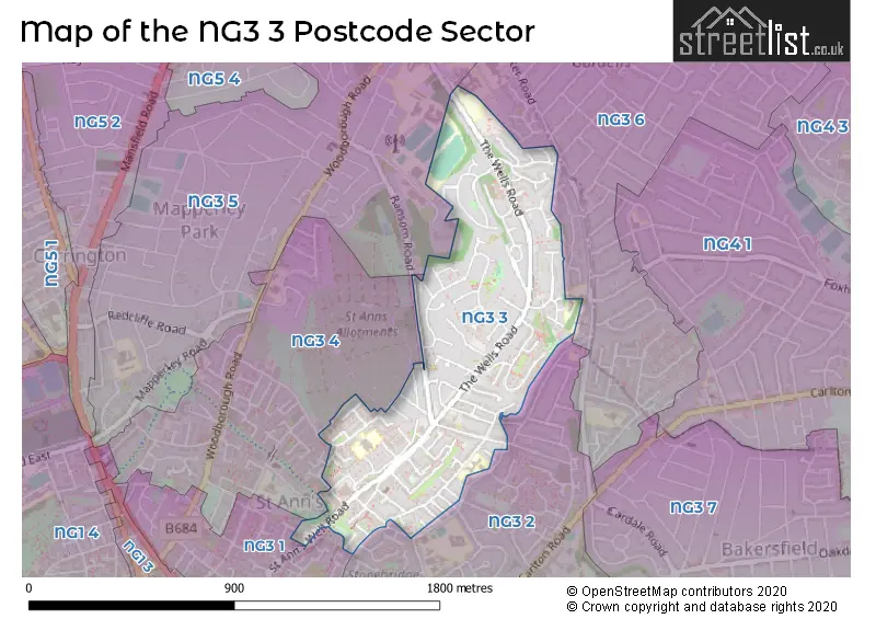
The NG3 3 Postcode shares a border with NG3 1 (NOTTINGHAM), NG3 2 (NOTTINGHAM, Thorneywood), NG3 4 (NOTTINGHAM), NG3 5 (NOTTINGHAM, Mapperley) and NG3 6 (NOTTINGHAM, Mapperley).
The sector is within the post town of NOTTINGHAM.
NG3 3 is a postcode sector within the NG3 postcode district which is within the NG Nottingham postcode area.
The Royal Mail delivery office for the NG3 3 postal sector is the Nottingham City Delivery Office.
The area of the NG3 3 postcode sector is 0.42 square miles which is 1.08 square kilometres or 267.94 square acres.

Map of the NG3 3 Postcode Sector
Explore the NG3 3 postcode sector by using our free interactive map.
| N | G | 3 | - | 3 | X | X |
| N | G | 3 | Space | 3 | Letter | Letter |
Official List of Streets
NOTTINGHAM (88 Streets)
Unofficial Streets or Alternative Spellings
Weather Forecast for NG3 3
Press Button to Show Forecast for Thorneywood
| Time Period | Icon | Description | Temperature | Rain Probability | Wind |
|---|---|---|---|---|---|
| 21:00 to 00:00 | Cloudy | 6.0°C (feels like 3.0°C) | 4.00% | ENE 9 mph |
Press Button to Show Forecast for Thorneywood
| Time Period | Icon | Description | Temperature | Rain Probability | Wind |
|---|---|---|---|---|---|
| 00:00 to 03:00 | Cloudy | 5.0°C (feels like 2.0°C) | 4.00% | NE 7 mph | |
| 03:00 to 06:00 | Cloudy | 4.0°C (feels like 1.0°C) | 6.00% | NE 7 mph | |
| 06:00 to 09:00 | Cloudy | 4.0°C (feels like 1.0°C) | 5.00% | NNE 9 mph | |
| 09:00 to 12:00 | Cloudy | 8.0°C (feels like 5.0°C) | 20.00% | ENE 11 mph | |
| 12:00 to 15:00 | Overcast | 9.0°C (feels like 7.0°C) | 19.00% | ENE 11 mph | |
| 15:00 to 18:00 | Overcast | 9.0°C (feels like 6.0°C) | 13.00% | ENE 11 mph | |
| 18:00 to 21:00 | Overcast | 8.0°C (feels like 5.0°C) | 11.00% | NE 11 mph | |
| 21:00 to 00:00 | Overcast | 6.0°C (feels like 3.0°C) | 11.00% | NE 11 mph |
Press Button to Show Forecast for Thorneywood
| Time Period | Icon | Description | Temperature | Rain Probability | Wind |
|---|---|---|---|---|---|
| 00:00 to 03:00 | Overcast | 6.0°C (feels like 2.0°C) | 13.00% | NNE 11 mph | |
| 03:00 to 06:00 | Heavy rain | 5.0°C (feels like 2.0°C) | 77.00% | N 13 mph | |
| 06:00 to 09:00 | Heavy rain | 5.0°C (feels like 1.0°C) | 84.00% | N 16 mph | |
| 09:00 to 12:00 | Heavy rain | 6.0°C (feels like 3.0°C) | 86.00% | NNW 13 mph | |
| 12:00 to 15:00 | Light rain | 7.0°C (feels like 4.0°C) | 49.00% | NW 11 mph | |
| 15:00 to 18:00 | Overcast | 9.0°C (feels like 7.0°C) | 19.00% | WNW 9 mph | |
| 18:00 to 21:00 | Partly cloudy (day) | 9.0°C (feels like 7.0°C) | 5.00% | W 9 mph | |
| 21:00 to 00:00 | Clear night | 6.0°C (feels like 4.0°C) | 3.00% | SW 7 mph |
Press Button to Show Forecast for Thorneywood
| Time Period | Icon | Description | Temperature | Rain Probability | Wind |
|---|---|---|---|---|---|
| 00:00 to 03:00 | Clear night | 5.0°C (feels like 3.0°C) | 1.00% | SW 7 mph | |
| 03:00 to 06:00 | Clear night | 4.0°C (feels like 1.0°C) | 0.00% | SSW 7 mph | |
| 06:00 to 09:00 | Sunny day | 5.0°C (feels like 2.0°C) | 1.00% | S 7 mph | |
| 09:00 to 12:00 | Sunny day | 10.0°C (feels like 8.0°C) | 1.00% | SSW 11 mph | |
| 12:00 to 15:00 | Cloudy | 13.0°C (feels like 10.0°C) | 5.00% | S 13 mph | |
| 15:00 to 18:00 | Cloudy | 14.0°C (feels like 11.0°C) | 6.00% | S 13 mph | |
| 18:00 to 21:00 | Partly cloudy (day) | 13.0°C (feels like 11.0°C) | 2.00% | S 9 mph | |
| 21:00 to 00:00 | Clear night | 9.0°C (feels like 7.0°C) | 1.00% | SSE 9 mph |
Press Button to Show Forecast for Thorneywood
| Time Period | Icon | Description | Temperature | Rain Probability | Wind |
|---|---|---|---|---|---|
| 00:00 to 03:00 | Clear night | 7.0°C (feels like 5.0°C) | 2.00% | SSE 7 mph | |
| 03:00 to 06:00 | Clear night | 6.0°C (feels like 4.0°C) | 2.00% | SE 7 mph | |
| 06:00 to 09:00 | Sunny day | 7.0°C (feels like 5.0°C) | 3.00% | ESE 7 mph | |
| 09:00 to 12:00 | Partly cloudy (day) | 12.0°C (feels like 10.0°C) | 4.00% | ESE 9 mph | |
| 12:00 to 15:00 | Cloudy | 15.0°C (feels like 13.0°C) | 8.00% | SE 11 mph | |
| 15:00 to 18:00 | Cloudy | 16.0°C (feels like 13.0°C) | 8.00% | ESE 11 mph | |
| 18:00 to 21:00 | Partly cloudy (day) | 14.0°C (feels like 12.0°C) | 6.00% | ESE 9 mph | |
| 21:00 to 00:00 | Cloudy | 11.0°C (feels like 10.0°C) | 9.00% | E 7 mph |
Schools and Places of Education Within the NG3 3 Postcode Sector
St Ann's Well Academy
Academy converter
Hungerhill Road, Nottingham, Nottinghamshire, NG3 3PQ
Head: Mrs Emma Thorne
Ofsted Rating: Good
Inspection: 2018-01-31 (2277 days ago)
Website: Visit St Ann's Well Academy Website
Phone: 01159155808
Number of Pupils: 234
House Prices in the NG3 3 Postcode Sector
| Type of Property | 2018 Average | 2018 Sales | 2017 Average | 2017 Sales | 2016 Average | 2016 Sales | 2015 Average | 2015 Sales |
|---|---|---|---|---|---|---|---|---|
| Detached | £144,333 | 9 | £132,409 | 11 | £136,000 | 7 | £137,765 | 15 |
| Semi-Detached | £118,630 | 27 | £116,617 | 31 | £113,375 | 18 | £105,953 | 34 |
| Terraced | £98,095 | 52 | £89,635 | 51 | £85,833 | 36 | £83,194 | 75 |
| Flats | £68,439 | 9 | £74,333 | 9 | £65,890 | 5 | £59,556 | 8 |
Important Postcodes NG3 3 in the Postcode Sector
NG3 3AA is the postcode for Nottinghamshire Healthcare NHS Trust, The Wells Road Centre, The Wells Road, Nottinghamshire Healthcare NHS Trust, The Wells Road Centre, and The Wells Road Centre, The Wells Road
NG3 3AB is the postcode for WALTER HALLS CHILDREN'S CENTRE, 589, The Wells Road
NG3 3AL is the postcode for Nottingham City Council, Thorneywood Education Base
NG3 3GG is the postcode for ST ANNS VALLEY CENTRE, 2 LIVINGSTONE ROAD, NOTTINGHAM, and St Ann's Valley Centre, 2 Livingstone Road
NG3 3HR is the postcode for Nottinghamshire Police, St. Anns Police Station
NG3 3NB is the postcode for St Anns Play Centre, 95 Nugent Gardens
NG3 3PQ is the postcode for St. Anns Well Academy, Hungerhill Road, and St. Anns Well Primary School, Hungerhill Road
NG3 3PX is the postcode for St. Anns Health Centre, St. Anns Well Road
| The NG3 3 Sector is within these Local Authorities |
|
|---|---|
| The NG3 3 Sector is within these Counties |
|
| The NG3 3 Sector is within these Water Company Areas |
|