The NG5 4 postcode sector is within the county of Nottinghamshire.
Did you know? According to the 2021 Census, the NG5 4 postcode sector is home to a bustling 9,053 residents!
Given that each sector allows for 400 unique postcode combinations. Letters C, I, K, M, O and V are not allowed in the last two letters of a postcode. With 191 postcodes already in use, this leaves 209 units available.
The largest settlement in the NG5 4 postal code is Woodthorpe followed by NOTTINGHAM, and Sherwood.
The NG5 4 Postcode shares a border with NG5 2 (NOTTINGHAM, Sherwood, Carrington), NG5 3 (NOTTINGHAM, Woodthorpe), NG5 6 (Arnold, Daybrook, NOTTINGHAM) and NG3 5 (NOTTINGHAM, Mapperley).
The sector is within the post town of NOTTINGHAM.
NG5 4 is a postcode sector within the NG5 postcode district which is within the NG Nottingham postcode area.
The Royal Mail delivery office for the NG5 4 postal sector is the Nottingham North Delivery Office.
The area of the NG5 4 postcode sector is 0.85 square miles which is 2.21 square kilometres or 546.63 square acres.

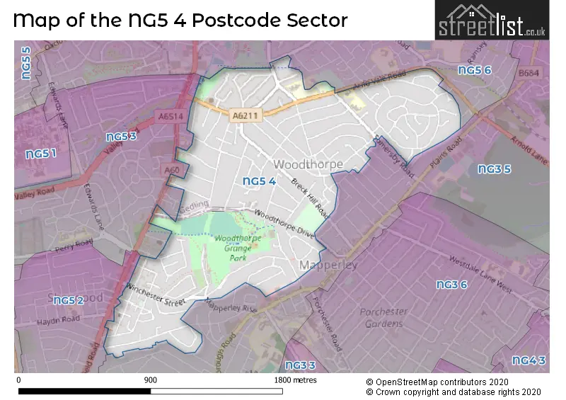
Map of the NG5 4 Postcode Sector
Explore the NG5 4 postcode sector by using our free interactive map.
| N | G | 5 | - | 4 | X | X |
| N | G | 5 | Space | 4 | Letter | Letter |
Official List of Streets
Woodthorpe (72 Streets)
NOTTINGHAM (39 Streets)
Sherwood (2 Streets)
Unofficial Streets or Alternative Spellings
NOTTINGHAM
BARDEN ROAD CRESTA GARDENS FOSTER DRIVE MALTBY ROAD MAURICE DRIVE OLD LODGE DRIVE PATELEY ROAD SHORTCROSS AVENUE TITHBY DRIVE TREVOSE GARDENS FAIRLAWN PLACE NORDEAN ROAD WYKEHAM ROADMapperley
CLIPSTONE AVENUE CLUMBER AVENUE PRIVATE ROAD SOMERSBY ROAD WOODTHORPE DRIVEArnold
ARNOT HILL ROAD GEDLING ROAD MANSFIELD ROAD SANDFIELD ROADWeather Forecast for NG5 4
Press Button to Show Forecast for Mapperley
| Time Period | Icon | Description | Temperature | Rain Probability | Wind |
|---|---|---|---|---|---|
| 18:00 to 21:00 | Cloudy | 21.0°C (feels like 20.0°C) | 4.00% | ESE 7 mph | |
| 21:00 to 00:00 | Partly cloudy (night) | 17.0°C (feels like 16.0°C) | 0.00% | ESE 7 mph |
Press Button to Show Forecast for Mapperley
| Time Period | Icon | Description | Temperature | Rain Probability | Wind |
|---|---|---|---|---|---|
| 00:00 to 03:00 | Partly cloudy (night) | 15.0°C (feels like 15.0°C) | 0.00% | SE 4 mph | |
| 03:00 to 06:00 | Partly cloudy (night) | 13.0°C (feels like 13.0°C) | 0.00% | SE 4 mph | |
| 06:00 to 09:00 | Partly cloudy (day) | 13.0°C (feels like 12.0°C) | 1.00% | ESE 4 mph | |
| 09:00 to 12:00 | Cloudy | 16.0°C (feels like 15.0°C) | 3.00% | ESE 7 mph | |
| 12:00 to 15:00 | Partly cloudy (day) | 21.0°C (feels like 19.0°C) | 0.00% | SE 9 mph | |
| 15:00 to 18:00 | Cloudy | 22.0°C (feels like 20.0°C) | 3.00% | SE 7 mph | |
| 18:00 to 21:00 | Cloudy | 20.0°C (feels like 18.0°C) | 3.00% | ESE 9 mph | |
| 21:00 to 00:00 | Cloudy | 17.0°C (feels like 15.0°C) | 4.00% | ESE 9 mph |
Press Button to Show Forecast for Mapperley
| Time Period | Icon | Description | Temperature | Rain Probability | Wind |
|---|---|---|---|---|---|
| 00:00 to 03:00 | Cloudy | 14.0°C (feels like 13.0°C) | 3.00% | E 7 mph | |
| 03:00 to 06:00 | Cloudy | 12.0°C (feels like 11.0°C) | 3.00% | E 4 mph | |
| 06:00 to 09:00 | Cloudy | 12.0°C (feels like 12.0°C) | 3.00% | ENE 4 mph | |
| 09:00 to 12:00 | Cloudy | 16.0°C (feels like 16.0°C) | 4.00% | E 7 mph | |
| 12:00 to 15:00 | Cloudy | 21.0°C (feels like 19.0°C) | 7.00% | SE 9 mph | |
| 15:00 to 18:00 | Cloudy | 21.0°C (feels like 19.0°C) | 18.00% | SSE 11 mph | |
| 18:00 to 21:00 | Light rain shower (day) | 20.0°C (feels like 18.0°C) | 40.00% | SSE 9 mph | |
| 21:00 to 00:00 | Cloudy | 17.0°C (feels like 16.0°C) | 16.00% | SSE 7 mph |
Press Button to Show Forecast for Mapperley
| Time Period | Icon | Description | Temperature | Rain Probability | Wind |
|---|---|---|---|---|---|
| 00:00 to 03:00 | Cloudy | 15.0°C (feels like 14.0°C) | 10.00% | S 7 mph | |
| 03:00 to 06:00 | Cloudy | 14.0°C (feels like 13.0°C) | 13.00% | S 7 mph | |
| 06:00 to 09:00 | Overcast | 13.0°C (feels like 12.0°C) | 13.00% | S 9 mph | |
| 09:00 to 12:00 | Overcast | 15.0°C (feels like 13.0°C) | 14.00% | S 9 mph | |
| 12:00 to 15:00 | Cloudy | 17.0°C (feels like 15.0°C) | 17.00% | S 11 mph | |
| 15:00 to 18:00 | Heavy rain | 17.0°C (feels like 14.0°C) | 76.00% | SSE 13 mph | |
| 18:00 to 21:00 | Heavy rain | 15.0°C (feels like 13.0°C) | 79.00% | SSE 11 mph | |
| 21:00 to 00:00 | Heavy rain | 14.0°C (feels like 12.0°C) | 77.00% | SSE 11 mph |
Press Button to Show Forecast for Mapperley
| Time Period | Icon | Description | Temperature | Rain Probability | Wind |
|---|---|---|---|---|---|
| 00:00 to 03:00 | Light rain | 13.0°C (feels like 11.0°C) | 55.00% | SSE 9 mph | |
| 03:00 to 06:00 | Cloudy | 12.0°C (feels like 10.0°C) | 18.00% | SSE 9 mph | |
| 06:00 to 09:00 | Cloudy | 12.0°C (feels like 10.0°C) | 11.00% | SSE 9 mph | |
| 09:00 to 12:00 | Light rain shower (day) | 13.0°C (feels like 11.0°C) | 34.00% | SSE 11 mph | |
| 12:00 to 15:00 | Light rain shower (day) | 16.0°C (feels like 13.0°C) | 35.00% | SSE 13 mph | |
| 15:00 to 18:00 | Light rain shower (day) | 16.0°C (feels like 13.0°C) | 38.00% | S 13 mph | |
| 18:00 to 21:00 | Light rain shower (day) | 15.0°C (feels like 13.0°C) | 35.00% | S 11 mph | |
| 21:00 to 00:00 | Clear night | 13.0°C (feels like 11.0°C) | 10.00% | S 9 mph |
Schools and Places of Education Within the NG5 4 Postcode Sector
Arno Vale Junior School
Community school
Saville Road, Nottingham, Nottinghamshire, NG5 4JF
Head: Mr A Rossington
Ofsted Rating: Good
Inspection: 2022-06-29 (681 days ago)
Website: Visit Arno Vale Junior School Website
Phone: 01159536400
Number of Pupils: 238
The Good Shepherd Catholic Primary, Arnold
Academy converter
Somersby Road, Nottingham, Nottinghamshire, NG5 4LT
Head: Mrs Celine Toner
Ofsted Rating: Good
Inspection: 2018-09-18 (2061 days ago)
Website: Visit The Good Shepherd Catholic Primary, Arnold Website
Phone: 01159262983
Number of Pupils: 450
Woodthorpe Infant School
Community school
Arno Vale Road, Nottingham, Nottinghamshire, NG5 4JG
Head: Mrs Emma Bowler
Ofsted Rating: Outstanding
Inspection: 2014-01-16 (3767 days ago)
Website: Visit Woodthorpe Infant School Website
Phone: 01159263820
Number of Pupils: 180
House Prices in the NG5 4 Postcode Sector
| Type of Property | 2018 Average | 2018 Sales | 2017 Average | 2017 Sales | 2016 Average | 2016 Sales | 2015 Average | 2015 Sales |
|---|---|---|---|---|---|---|---|---|
| Detached | £290,271 | 89 | £263,846 | 90 | £265,740 | 83 | £267,321 | 92 |
| Semi-Detached | £208,700 | 35 | £211,276 | 38 | £193,853 | 43 | £176,548 | 46 |
| Terraced | £159,432 | 19 | £135,675 | 10 | £128,878 | 16 | £142,897 | 15 |
| Flats | £131,917 | 18 | £116,917 | 12 | £125,900 | 25 | £109,583 | 15 |
Important Postcodes NG5 4 in the Postcode Sector
NG5 4AB is the postcode for Sherwood Library, Spondon Street
NG5 4AD is the postcode for Sherwood Health Centre, Elmswood Gardens
NG5 4HA is the postcode for Nottingham City Council, Woodthorpe Grange
NG5 4JF is the postcode for Arno Vale Junior School, Saville Road, Arno Vale School, Saville Road, and ARNO VALE JUNIOR SCHOOL, SAVILLE ROAD, WOODTHORPE
NG5 4JG is the postcode for Woodthorpe Infants School, Arno Vale Road, and Woodthorpe Infants School, Arno Vale Road, Woodthorpe
NG5 4LT is the postcode for Good Shepherd Primary School, St. Anne's Infant Annexe, The Good Shepherd Primary Catholic Voluntary Academy, Somersby Road, The Good Shepherd Primary Catholic Voluntary Academy, Somersby Road, Woodthorpe, and Good Shepherd Primary School, St. Anne's Infant Annexe, Somersby Road, Woodthorpe
| The NG5 4 Sector is within these Local Authorities |
|
|---|---|
| The NG5 4 Sector is within these Counties |
|
| The NG5 4 Sector is within these Water Company Areas |
|