The NG7 5 postcode sector is within the county of Nottinghamshire.
Did you know? According to the 2021 Census, the NG7 5 postcode sector is home to a bustling 9,446 residents!
Given that each sector allows for 400 unique postcode combinations. Letters C, I, K, M, O and V are not allowed in the last two letters of a postcode. With 159 postcodes already in use, this leaves 241 units available.
The NG7 5 postal code covers the settlement of NOTTINGHAM.
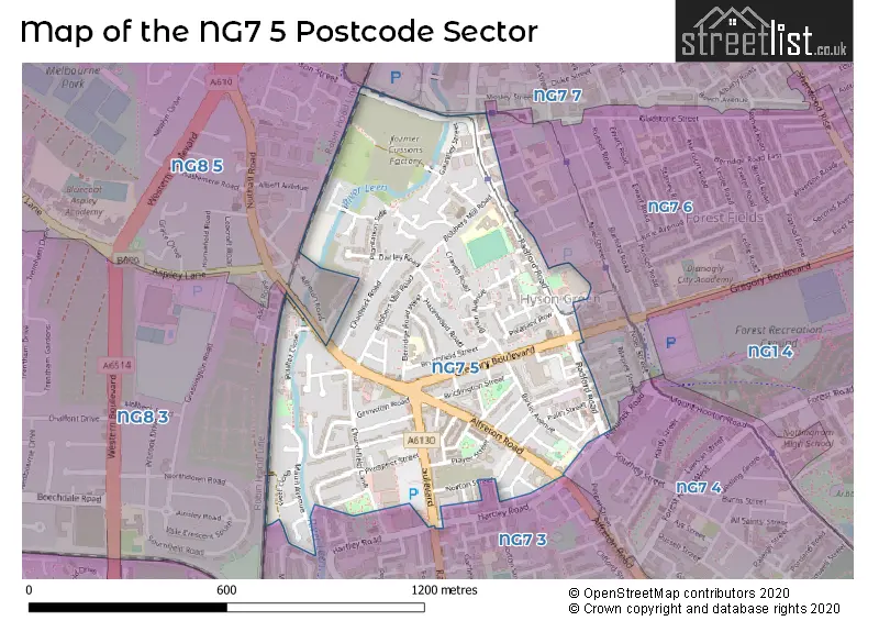
The NG7 5 Postcode shares a border with NG7 3 (NOTTINGHAM), NG7 6 (NOTTINGHAM, Forest Fields), NG8 5 (NOTTINGHAM), NG7 4 (NOTTINGHAM), NG7 7 (NOTTINGHAM, New Basford) and NG8 3 (NOTTINGHAM).
The sector is within the post town of NOTTINGHAM.
NG7 5 is a postcode sector within the NG7 postcode district which is within the NG Nottingham postcode area.
The Royal Mail delivery office for the NG7 5 postal sector is the Glaisdale Parkway Delivery Office.
The area of the NG7 5 postcode sector is 0.36 square miles which is 0.94 square kilometres or 231.09 square acres.
Waterways within the NG7 5 postcode sector include the River Leen.

Map of the NG7 5 Postcode Sector
Explore the NG7 5 postcode sector by using our free interactive map.
| N | G | 7 | - | 5 | X | X |
| N | G | 7 | Space | 5 | Letter | Letter |
Official List of Streets
NOTTINGHAM (85 Streets)
Unofficial Streets or Alternative Spellings
NOTTINGHAM
ARMSTRONG WAY BEACONSFIELD STREET BELPER ROAD BELTON STREET BERRIDGE ROAD CENTRAL CLAYPOLE ROAD GAUNTLEY COURT GLADSTONE STREET GOODLIFFE STREET HARTLEY ROAD HAWKSLEY ROAD MIDLAND WAY NEW ROAD NORTON STREET PATTERSON ROAD SCOTHOLME AVENUE SELHURST COURT TERRACE STREET WILKINSON STREET BOBBERS MILL BRIDGE BROOK COURT BURWELL STREET DALKEITH TERRACE GEMSTONE COURT GOODALL STREET GOODHALL STREET HAWARDEN TERRACE HYSON STREET KIRKSTEAD STREET NOTTINGHAM EXPRESS TRANSIT LINE 1 PROSPECT CLOSE RANDAL STREET TEMPLAR COURT THORNLEY STREET WARD STREET WOODBRIDGE COURTNew Basford
RADFORD ROADWeather Forecast for NG7 5
Press Button to Show Forecast for Whitemoor
| Time Period | Icon | Description | Temperature | Rain Probability | Wind |
|---|---|---|---|---|---|
| 06:00 to 09:00 | Cloudy | 5.0°C (feels like 2.0°C) | 6.00% | NNE 7 mph | |
| 09:00 to 12:00 | Cloudy | 8.0°C (feels like 6.0°C) | 13.00% | ENE 9 mph | |
| 12:00 to 15:00 | Overcast | 9.0°C (feels like 7.0°C) | 22.00% | ENE 9 mph | |
| 15:00 to 18:00 | Overcast | 9.0°C (feels like 7.0°C) | 15.00% | ENE 11 mph | |
| 18:00 to 21:00 | Overcast | 8.0°C (feels like 6.0°C) | 16.00% | NE 11 mph | |
| 21:00 to 00:00 | Cloudy | 7.0°C (feels like 4.0°C) | 11.00% | NE 11 mph |
Press Button to Show Forecast for Whitemoor
| Time Period | Icon | Description | Temperature | Rain Probability | Wind |
|---|---|---|---|---|---|
| 00:00 to 03:00 | Overcast | 6.0°C (feels like 3.0°C) | 12.00% | NNE 11 mph | |
| 03:00 to 06:00 | Light rain | 6.0°C (feels like 2.0°C) | 57.00% | N 13 mph | |
| 06:00 to 09:00 | Heavy rain | 6.0°C (feels like 2.0°C) | 82.00% | N 13 mph | |
| 09:00 to 12:00 | Heavy rain | 7.0°C (feels like 3.0°C) | 83.00% | NNW 13 mph | |
| 12:00 to 15:00 | Light rain | 8.0°C (feels like 5.0°C) | 47.00% | NW 11 mph | |
| 15:00 to 18:00 | Cloudy | 10.0°C (feels like 8.0°C) | 15.00% | WNW 9 mph | |
| 18:00 to 21:00 | Partly cloudy (day) | 10.0°C (feels like 8.0°C) | 6.00% | W 9 mph | |
| 21:00 to 00:00 | Partly cloudy (night) | 7.0°C (feels like 6.0°C) | 3.00% | SW 7 mph |
Press Button to Show Forecast for Whitemoor
| Time Period | Icon | Description | Temperature | Rain Probability | Wind |
|---|---|---|---|---|---|
| 00:00 to 03:00 | Clear night | 6.0°C (feels like 4.0°C) | 1.00% | SW 7 mph | |
| 03:00 to 06:00 | Clear night | 4.0°C (feels like 2.0°C) | 0.00% | SSW 4 mph | |
| 06:00 to 09:00 | Sunny day | 5.0°C (feels like 3.0°C) | 1.00% | S 7 mph | |
| 09:00 to 12:00 | Sunny day | 11.0°C (feels like 8.0°C) | 1.00% | S 11 mph | |
| 12:00 to 15:00 | Overcast | 14.0°C (feels like 11.0°C) | 8.00% | S 13 mph | |
| 15:00 to 18:00 | Cloudy | 14.0°C (feels like 11.0°C) | 7.00% | S 13 mph | |
| 18:00 to 21:00 | Partly cloudy (day) | 14.0°C (feels like 11.0°C) | 3.00% | S 11 mph | |
| 21:00 to 00:00 | Clear night | 10.0°C (feels like 9.0°C) | 2.00% | SSE 9 mph |
Press Button to Show Forecast for Whitemoor
| Time Period | Icon | Description | Temperature | Rain Probability | Wind |
|---|---|---|---|---|---|
| 00:00 to 03:00 | Clear night | 8.0°C (feels like 6.0°C) | 2.00% | SE 7 mph | |
| 03:00 to 06:00 | Clear night | 7.0°C (feels like 5.0°C) | 2.00% | ESE 7 mph | |
| 06:00 to 09:00 | Sunny day | 8.0°C (feels like 6.0°C) | 3.00% | ESE 7 mph | |
| 09:00 to 12:00 | Partly cloudy (day) | 12.0°C (feels like 10.0°C) | 4.00% | ESE 9 mph | |
| 12:00 to 15:00 | Partly cloudy (day) | 16.0°C (feels like 13.0°C) | 5.00% | ESE 11 mph | |
| 15:00 to 18:00 | Cloudy | 16.0°C (feels like 14.0°C) | 10.00% | ESE 11 mph | |
| 18:00 to 21:00 | Cloudy | 15.0°C (feels like 13.0°C) | 8.00% | ESE 9 mph | |
| 21:00 to 00:00 | Cloudy | 12.0°C (feels like 11.0°C) | 12.00% | E 9 mph |
Schools and Places of Education Within the NG7 5 Postcode Sector
Berridge Primary and Nursery School
Community school
Brushfield Site, Nottingham, Nottinghamshire, NG7 5LE
Head: Mr James Tee
Ofsted Rating: Good
Inspection: 2019-07-11 (1752 days ago)
Website: Visit Berridge Primary and Nursery School Website
Phone: 01159155813
Number of Pupils: 613
House Prices in the NG7 5 Postcode Sector
| Type of Property | 2018 Average | 2018 Sales | 2017 Average | 2017 Sales | 2016 Average | 2016 Sales | 2015 Average | 2015 Sales |
|---|---|---|---|---|---|---|---|---|
| Detached | £171,000 | 6 | £164,000 | 2 | £156,400 | 5 | £135,500 | 2 |
| Semi-Detached | £139,763 | 19 | £117,496 | 14 | £121,184 | 19 | £109,685 | 27 |
| Terraced | £103,832 | 70 | £100,088 | 66 | £89,959 | 48 | £90,412 | 59 |
| Flats | £63,750 | 4 | £64,108 | 12 | £62,444 | 9 | £54,667 | 3 |
Important Postcodes NG7 5 in the Postcode Sector
NG7 5GX is the postcode for Radford Road Police Station, Radford Road
NG7 5GY is the postcode for Berridge Infant School, Bobbers Mill Road, and BERRIDGE INFANT SCHOOL, BOBBERS MILL ROAD, NOTTINGHAM
NG7 5HY is the postcode for Nottingham Community Health NHS Trust, Gregory Boulevard, and The Mary Potter Centre, Gregory Boulevard
NG7 5LE is the postcode for BERRIDGE JUNIOR SCHOOL, BERRIDGE ROAD WEST, NOTTINGHAM, Berridge Junior School, Berridge Road, and Berridge Junior School, Berridge Road West
| The NG7 5 Sector is within these Local Authorities |
|
|---|---|
| The NG7 5 Sector is within these Counties |
|
| The NG7 5 Sector is within these Water Company Areas |
|