The NG9 5 postcode sector is within the county of Nottinghamshire.
Did you know? According to the 2021 Census, the NG9 5 postcode sector is home to a bustling 8,373 residents!
Given that each sector allows for 400 unique postcode combinations. Letters C, I, K, M, O and V are not allowed in the last two letters of a postcode. With 179 postcodes already in use, this leaves 221 units available.
The largest settlements in the NG9 5 postal code are Beeston and Attenborough.
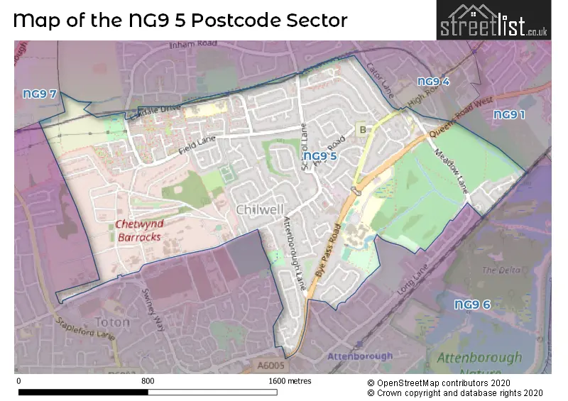
The NG9 5 Postcode shares a border with NG9 4 (Beeston), NG9 7 (Stapleford), NG9 1 (Beeston) and NG9 6 (Toton, Beeston, Attenborough).
The sector is within the post town of NOTTINGHAM.
NG9 5 is a postcode sector within the NG9 postcode district which is within the NG Nottingham postcode area.
The Royal Mail delivery office for the NG9 5 postal sector is the Beeston Delivery Office.
The area of the NG9 5 postcode sector is 1.06 square miles which is 2.75 square kilometres or 679.45 square acres.

Map of the NG9 5 Postcode Sector
Explore the NG9 5 postcode sector by using our free interactive map.
| N | G | 9 | - | 5 | X | X |
| N | G | 9 | Space | 5 | Letter | Letter |
Official List of Streets
Beeston (112 Streets)
Toton (1 Streets)
Unofficial Streets or Alternative Spellings
Beeston
AUDON AVENUE BORROWDALE COURT CATOR LANE CHEVIOT COURT GATEHOUSE COURT INHAM ROAD MARTELL COURT NEWALL DRIVE ORDNANCE COURT PATTERDALE COURT RANSON ROAD RATHVALE COURT BODY ROAD BRENTNALL COURT CHURCH CRESCENT DAVIS ROAD ELIZABETH ROAD FULLWOOD CLOSE GELL ROAD GHOST HOUSE LANE HILL ROAD HILLSIDE ROAD NILSSON ROAD PAYNE ROAD QUEEN ELIZABETH ROAD READMAN ROAD RETLAW COURT TOFT ROAD TOPCLIFF ROAD TOWLSON COURT ULMUS COURT VAUGHAN ROAD WESTMONER COURT WHITTAKER ROADAttenborough
ATTENBOROUGH LANE BARRATT LANE NOTTINGHAM ROADWeather Forecast for NG9 5
Press Button to Show Forecast for Chilwell
| Time Period | Icon | Description | Temperature | Rain Probability | Wind |
|---|---|---|---|---|---|
| 21:00 to 00:00 | Cloudy | 7.0°C (feels like 4.0°C) | 5.00% | ENE 7 mph |
Press Button to Show Forecast for Chilwell
| Time Period | Icon | Description | Temperature | Rain Probability | Wind |
|---|---|---|---|---|---|
| 00:00 to 03:00 | Cloudy | 6.0°C (feels like 3.0°C) | 5.00% | NE 7 mph | |
| 03:00 to 06:00 | Partly cloudy (night) | 5.0°C (feels like 3.0°C) | 2.00% | NE 7 mph | |
| 06:00 to 09:00 | Cloudy | 5.0°C (feels like 2.0°C) | 5.00% | NE 7 mph | |
| 09:00 to 12:00 | Cloudy | 8.0°C (feels like 6.0°C) | 11.00% | ENE 11 mph | |
| 12:00 to 15:00 | Overcast | 10.0°C (feels like 7.0°C) | 21.00% | ENE 9 mph | |
| 15:00 to 18:00 | Overcast | 9.0°C (feels like 7.0°C) | 13.00% | ENE 11 mph | |
| 18:00 to 21:00 | Overcast | 8.0°C (feels like 6.0°C) | 12.00% | NE 11 mph | |
| 21:00 to 00:00 | Overcast | 7.0°C (feels like 4.0°C) | 11.00% | NE 11 mph |
Press Button to Show Forecast for Chilwell
| Time Period | Icon | Description | Temperature | Rain Probability | Wind |
|---|---|---|---|---|---|
| 00:00 to 03:00 | Overcast | 7.0°C (feels like 3.0°C) | 11.00% | NNE 11 mph | |
| 03:00 to 06:00 | Light rain | 6.0°C (feels like 2.0°C) | 57.00% | N 13 mph | |
| 06:00 to 09:00 | Heavy rain | 6.0°C (feels like 2.0°C) | 83.00% | N 13 mph | |
| 09:00 to 12:00 | Heavy rain | 7.0°C (feels like 3.0°C) | 83.00% | NNW 13 mph | |
| 12:00 to 15:00 | Light rain | 8.0°C (feels like 5.0°C) | 47.00% | NW 11 mph | |
| 15:00 to 18:00 | Cloudy | 10.0°C (feels like 8.0°C) | 15.00% | WNW 9 mph | |
| 18:00 to 21:00 | Partly cloudy (day) | 10.0°C (feels like 8.0°C) | 6.00% | W 9 mph | |
| 21:00 to 00:00 | Clear night | 8.0°C (feels like 6.0°C) | 3.00% | SW 7 mph |
Press Button to Show Forecast for Chilwell
| Time Period | Icon | Description | Temperature | Rain Probability | Wind |
|---|---|---|---|---|---|
| 00:00 to 03:00 | Clear night | 6.0°C (feels like 4.0°C) | 1.00% | SW 7 mph | |
| 03:00 to 06:00 | Clear night | 5.0°C (feels like 3.0°C) | 0.00% | SSW 4 mph | |
| 06:00 to 09:00 | Sunny day | 5.0°C (feels like 3.0°C) | 1.00% | S 7 mph | |
| 09:00 to 12:00 | Sunny day | 11.0°C (feels like 8.0°C) | 1.00% | S 11 mph | |
| 12:00 to 15:00 | Cloudy | 14.0°C (feels like 11.0°C) | 5.00% | S 13 mph | |
| 15:00 to 18:00 | Cloudy | 14.0°C (feels like 12.0°C) | 6.00% | S 13 mph | |
| 18:00 to 21:00 | Partly cloudy (day) | 14.0°C (feels like 12.0°C) | 4.00% | S 11 mph | |
| 21:00 to 00:00 | Clear night | 11.0°C (feels like 9.0°C) | 2.00% | SSE 9 mph |
Press Button to Show Forecast for Chilwell
| Time Period | Icon | Description | Temperature | Rain Probability | Wind |
|---|---|---|---|---|---|
| 00:00 to 03:00 | Clear night | 9.0°C (feels like 7.0°C) | 2.00% | SE 7 mph | |
| 03:00 to 06:00 | Clear night | 7.0°C (feels like 5.0°C) | 2.00% | ESE 7 mph | |
| 06:00 to 09:00 | Sunny day | 8.0°C (feels like 6.0°C) | 3.00% | ESE 7 mph | |
| 09:00 to 12:00 | Partly cloudy (day) | 12.0°C (feels like 10.0°C) | 4.00% | ESE 9 mph | |
| 12:00 to 15:00 | Partly cloudy (day) | 16.0°C (feels like 13.0°C) | 5.00% | SE 11 mph | |
| 15:00 to 18:00 | Cloudy | 16.0°C (feels like 14.0°C) | 10.00% | ESE 11 mph | |
| 18:00 to 21:00 | Cloudy | 15.0°C (feels like 13.0°C) | 9.00% | ESE 9 mph | |
| 21:00 to 00:00 | Cloudy | 12.0°C (feels like 11.0°C) | 9.00% | E 9 mph |
Schools and Places of Education Within the NG9 5 Postcode Sector
Alderman Pounder Infant and Nursery School
Academy converter
Eskdale Drive, Nottingham, Nottinghamshire, NG9 5FN
Head: Mr Adam Butterworth-Drury
Ofsted Rating: Good
Inspection: 2023-01-11 (471 days ago)
Website: Visit Alderman Pounder Infant and Nursery School Website
Phone: 01159252928
Number of Pupils: 235
Chilwell School
Foundation school
Queens Road, Nottingham, Nottinghamshire, NG9 5AL
Head: Mr David Phillips
Ofsted Rating: Good
Inspection: 2018-05-09 (2179 days ago)
Website: Visit Chilwell School Website
Phone: 01159252698
Number of Pupils: 1053
Eskdale Junior School
Community school
Eskdale Drive, Nottingham, Nottinghamshire, NG9 5NA
Head: Mr Robin Scruton
Ofsted Rating: Outstanding
Inspection: 2013-06-28 (3955 days ago)
Website: Visit Eskdale Junior School Website
Phone: 01159179272
Number of Pupils: 260
House Prices in the NG9 5 Postcode Sector
| Type of Property | 2018 Average | 2018 Sales | 2017 Average | 2017 Sales | 2016 Average | 2016 Sales | 2015 Average | 2015 Sales |
|---|---|---|---|---|---|---|---|---|
| Detached | £301,453 | 43 | £263,156 | 44 | £261,779 | 43 | £233,529 | 36 |
| Semi-Detached | £197,960 | 62 | £180,925 | 80 | £167,861 | 88 | £160,170 | 43 |
| Terraced | £161,536 | 14 | £157,602 | 23 | £147,102 | 24 | £141,046 | 23 |
| Flats | £106,650 | 3 | £97,550 | 10 | £102,443 | 7 | £97,500 | 2 |
Important Postcodes NG9 5 in the Postcode Sector
NG9 5AA is the postcode for Meadow Lane Infant School, Meadow Lane
NG9 5AL is the postcode for Chilwell School, Queens Road, MAIN SCHOOL, Chilwell School, Queens Road, LEISURE CENTRE, Chilwell School, Queens Road, MUSIC BLOCK, Chilwell School, Queens Road, and LAKEVIEW 6TH FORM CENTRE, Chilwell School, Queens Road
NG9 5FN is the postcode for Alderman Pounder Infant School, Eskdale Drive, and Alderman Pounder Infant School, Eskdale Drive, Beeston
NG9 5NA is the postcode for Eskdale Junior School, Eskdale Drive, Beeston, ESKDALE JUNIOR SCHOOL, ESKDALE DRIVE, CHILWELL, and Eskdale Junior School, Eskdale Drive
| The NG9 5 Sector is within these Local Authorities |
|
|---|---|
| The NG9 5 Sector is within these Counties |
|
| The NG9 5 Sector is within these Water Company Areas |
|