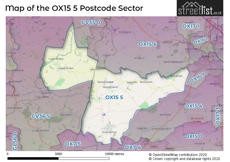
The OX15 5 postcode sector stands on the Oxfordshire and Warwickshire border.
Did you know? According to the 2021 Census, the OX15 5 postcode sector is home to a bustling 5,400 residents!
Given that each sector allows for 400 unique postcode combinations. Letters C, I, K, M, O and V are not allowed in the last two letters of a postcode. With 251 postcodes already in use, this leaves 149 units available.
The largest settlement in the OX15 5 postal code is Hook Norton followed by Lower Brailes, and Sibford Ferris.
The OX15 5 Postcode shares a border with OX15 6 (Wroxton, Shenington, Shutford), OX7 4 (Enstone, Swerford, Great Tew), OX7 5 (CHIPPING NORTON, Great Rollright, Over Norton), OX15 4 (Bloxham, Bodicote, Milcombe), OX16 9 (BANBURY), CV35 0 (Kineton, Lighthorne, Gaydon) and CV36 5 (Long Compton, Halford, Cherington).
The sector is within the post town of BANBURY.
OX15 5 is a postcode sector within the OX1 postcode district which is within the OX Oxford postcode area.
The Royal Mail delivery office for the OX15 5 postal sector is the Oxford Delivery Office.
The area of the OX15 5 postcode sector is 25.11 square miles which is 65.03 square kilometres or 16,068.40 square acres.

Map of the OX15 5 Postcode Sector
Explore the OX15 5 postcode sector by using our free interactive map.
| O | X | 1 | 5 | - | 5 | X | X |
| O | X | 1 | 5 | Space | 5 | Letter | Letter |
Official List of Streets
Hook Norton (56 Streets)
Swalcliffe (9 Streets)
Upper Brailes (4 Streets)
Sibford Gower (6 Streets)
Lower Brailes (19 Streets)
Sibford Ferris (8 Streets)
Broughton (5 Streets)
Sutton Under Brailes (1 Streets)
Burdrop (2 Streets)
Lower Tadmarton (2 Streets)
Schools and Places of Education Within the OX15 5 Postcode Sector
Hook Norton Church of England Primary School
Voluntary controlled school
Sibford Road, Banbury, Oxfordshire, OX15 5JS
Head: Mrs N Crouch
Ofsted Rating: Good
Inspection: 2023-03-22 (431 days ago)
Website: Visit Hook Norton Church of England Primary School Website
Phone: 01608737379
Number of Pupils: 294
Sibford Gower Endowed Primary School
Academy converter
Acre Ditch, Banbury, Oxfordshire, OX15 5RW
Head: Ms Jane O'Sullivan
Ofsted Rating: Good
Inspection: 2023-11-01 (207 days ago)
Website: Visit Sibford Gower Endowed Primary School Website
Phone: 01295780270
Number of Pupils: 110
Swalcliffe Park School CIO
Non-maintained special school
Swalcliffe, Banbury, Oxfordshire, OX15 5EP
Head: Mr Rob Piner
Ofsted Rating: Outstanding
Inspection: 2019-07-03 (1789 days ago)
Website: Visit Swalcliffe Park School CIO Website
Phone: 01295780302
Number of Pupils: 73
House Prices in the OX15 5 Postcode Sector
| Type of Property | 2018 Average | 2018 Sales | 2017 Average | 2017 Sales | 2016 Average | 2016 Sales | 2015 Average | 2015 Sales |
|---|---|---|---|---|---|---|---|---|
| Detached | £557,956 | 34 | £509,594 | 45 | £425,871 | 68 | £506,559 | 52 |
| Semi-Detached | £350,598 | 20 | £316,481 | 26 | £290,681 | 31 | £285,850 | 22 |
| Terraced | £275,660 | 20 | £325,804 | 13 | £261,344 | 16 | £340,985 | 27 |
| Flats | £316,000 | 1 | £277,150 | 3 | £180,000 | 1 | £0 | 0 |
Important Postcodes OX15 5 in the Postcode Sector
OX15 5JS is the postcode for Hook Norton C of E Primary School, Sibford Road, Hook Norton, and Hook Norton C of E Primary School, Sibford Road
| The OX15 5 Sector is within these Local Authorities |
|
|---|---|
| The OX15 5 Sector is within these Counties |
|
| The OX15 5 Sector is within these Water Company Areas |
|
Tourist Attractions within the OX15 5 Postcode Area
We found 2 visitor attractions within the OX1 postcode area
| Swalcliffe Barn |
|---|
| Museums & Art Galleries |
| Museum and / or Art Gallery |
| View Swalcliffe Barn on Google Maps |
| Broughton Castle |
| Historic Properties |
| Castle / Fort |
| View Broughton Castle on Google Maps |