The OX16 2 postcode sector stands on the Northamptonshire and Oxfordshire border.
Did you know? According to the 2021 Census, the OX16 2 postcode sector is home to a bustling 3,631 residents!
Given that each sector allows for 400 unique postcode combinations. Letters C, I, K, M, O and V are not allowed in the last two letters of a postcode. With 107 postcodes already in use, this leaves 293 units available.
The OX16 2 postal code covers the settlement of BANBURY.
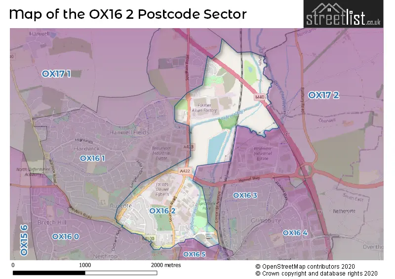
The OX16 2 Postcode shares a border with OX16 0 (BANBURY), OX16 1 (BANBURY), OX16 3 (BANBURY), OX16 5 (BANBURY), OX17 1 (Cropredy, Chipping Warden, Mollington) and OX17 2 (Middleton Cheney, Greatworth, Chacombe).
The sector is within the post town of BANBURY.
OX16 2 is a postcode sector within the OX1 postcode district which is within the OX Oxford postcode area.
The Royal Mail delivery office for the OX16 2 postal sector is the Oxford Delivery Office.
The area of the OX16 2 postcode sector is 0.99 square miles which is 2.55 square kilometres or 630.54 square acres.
The OX16 2 postcode sector is crossed by the M40 motorway.
Waterways within the OX16 2 postcode sector include the Oxford Canal.

Map of the OX16 2 Postcode Sector
Explore the OX16 2 postcode sector by using our free interactive map.
| O | X | 1 | 6 | - | 2 | X | X |
| O | X | 1 | 6 | Space | 2 | Letter | Letter |
Official List of Streets
BANBURY (41 Streets)
Schools and Places of Education Within the OX16 2 Postcode Sector
Cherry Fields Primary School
Free schools
Wardington Road, Banbury, Oxfordshire, OX16 2DF
Head: Mrs Claire Robertson
Ofsted Rating: Outstanding
Inspection: 2022-12-07 (536 days ago)
Website: Visit Cherry Fields Primary School Website
Phone: 01295574004
Number of Pupils: 100
St Mary's Church of England Primary School, Banbury
Academy converter
St Mary's C of E Primary School Southam Road, Banbury, Oxfordshire, OX16 2EG
Head: Mrs Victoria Woods
Ofsted Rating: Good
Inspection: 2022-03-03 (815 days ago)
Website: Visit St Mary's Church of England Primary School, Banbury Website
Phone: 01295263026
Number of Pupils: 215
House Prices in the OX16 2 Postcode Sector
| Type of Property | 2018 Average | 2018 Sales | 2017 Average | 2017 Sales | 2016 Average | 2016 Sales | 2015 Average | 2015 Sales |
|---|---|---|---|---|---|---|---|---|
| Detached | £397,894 | 34 | £400,996 | 19 | £321,249 | 8 | £0 | 0 |
| Semi-Detached | £280,034 | 40 | £298,469 | 55 | £273,098 | 29 | £220,111 | 18 |
| Terraced | £247,175 | 23 | £215,758 | 20 | £215,501 | 11 | £210,983 | 21 |
| Flats | £163,750 | 14 | £149,702 | 27 | £149,352 | 29 | £144,431 | 26 |
Important Postcodes OX16 2 in the Postcode Sector
OX16 2AE is the postcode for Thames Valley Police, Banbury Police Station, Warwick Road
OX16 2AW is the postcode for Banbury Magistrates & County Court, The Court House
OX16 2BW is the postcode for Spiceball Leisure Centre, Cherwell Drive
OX16 2DF is the postcode for Cherry Fields Primary School, Wardington Road
OX16 2EG is the postcode for St. Marys C of E Primary School, Southam Road
OX16 2EX is the postcode for Jobcentre Plus, Crown Buildings, Southam Road, Crown Buildings, Southam Road, and Jobcentre Plus, Crown Buildings
OX16 2EZ is the postcode for THE ORCHARD HEALTH CENTRE, COPE ROAD, BANBURY, and The Orchard Health Centre, Cope Road
OX16 2NT is the postcode for Redlands Centre, Neithrop Avenue
OX16 2PQ is the postcode for Banbury Museum Heritage Centre, Cafe Quay, Spiceball Park Road
OX16 2ZA is the postcode for Greenwood Centre, Parklands, Warwick Road
| The OX16 2 Sector is within these Local Authorities |
|
|---|---|
| The OX16 2 Sector is within these Counties |
|
| The OX16 2 Sector is within these Water Company Areas |
|