The PE11 1 postcode sector is within the county of Lincolnshire.
Did you know? According to the 2021 Census, the PE11 1 postcode sector is home to a bustling 10,023 residents!
Given that each sector allows for 400 unique postcode combinations. Letters C, I, K, M, O and V are not allowed in the last two letters of a postcode. With 256 postcodes already in use, this leaves 144 units available.
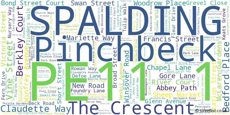
The largest settlements in the PE11 1 postal code are SPALDING and Pinchbeck.
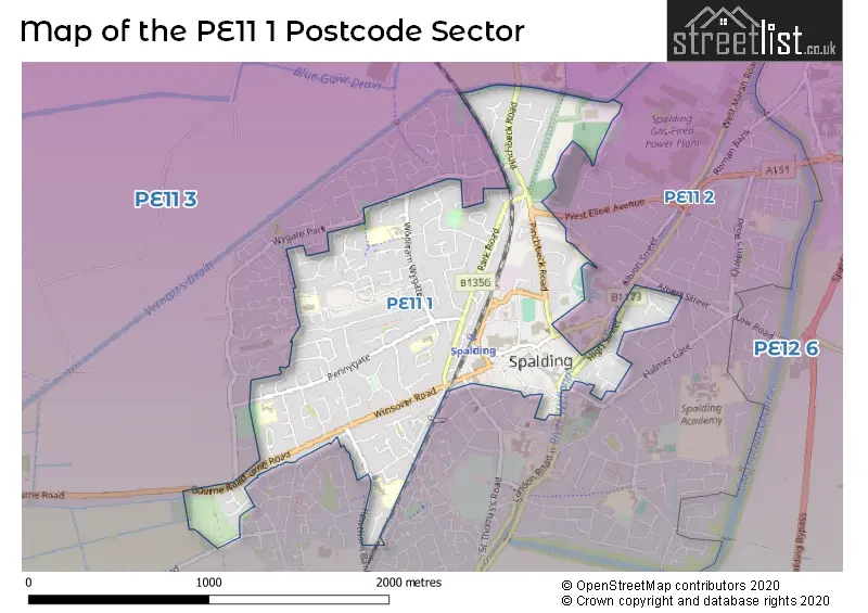
The PE11 1 Postcode shares a border with PE11 2 (SPALDING) and PE11 3 (SPALDING, Pinchbeck, Deeping St. Nicholas).
The sector is within the post town of SPALDING.
PE11 1 is a postcode sector within the PE11 postcode district which is within the PE Peterborough postcode area.
The Royal Mail delivery office for the PE11 1 postal sector is the Spalding Delivery Office.
The area of the PE11 1 postcode sector is 1.01 square miles which is 2.62 square kilometres or 648.60 square acres.
Waterways within the PE11 1 postcode sector include the River Welland.

Map of the PE11 1 Postcode Sector
Explore the PE11 1 postcode sector by using our free interactive map.
| P | E | 1 | 1 | - | 1 | X | X |
| P | E | 1 | 1 | Space | 1 | Letter | Letter |
Official List of Streets
SPALDING (173 Streets)
Pinchbeck (3 Streets)
Unofficial Streets or Alternative Spellings
SPALDING
CHURCH STREET CLEY HALL GARDENS CLOVER WAY DOUBLE STREET HORSESHOE ROAD KNIPE AVENUE LONDON ROAD MEDINA WALK MONKS HOUSE LANE PRIORY ROAD SPRING GARDENS STOUR CLOSE THE PARKWAY TYNE CLOSE VAN GOGH DRIVE WEST ELLOE AVENUE WESTLODE STREET WITHAM ROAD ABBEY HOUSE ABBEY YARD BATH LANE BETJEMAN GROVE BRAYDON CLOSE BROADWAY BUTTER MARKET CAULDER CLOSE CHERWELL CLOSE CHURCH GATE CLEMENS TERRACE DRAPERS PLACE HIGH BRIDGE HOLE IN THE WALL IRWELL CLOSE MICHAELS MEWS MINSMERE CLOSE PULMAN COURT SOLENT DRIVE ST ANNES WAY ST THOMASS ROAD STATION APPROACH TAKU BRIDGE TAMAR CLOSE THISLE GARDENS WAVENEY CLOSE WHYBURN CLOSE WILLOW ROW WINSMERE CLOSE WYGATE PARKPode Hole
BOURNE ROADPinchbeck
SPALDING ROADWeather Forecast for PE11 1
Press Button to Show Forecast for Spalding
| Time Period | Icon | Description | Temperature | Rain Probability | Wind |
|---|---|---|---|---|---|
| 21:00 to 00:00 | Cloudy | 7.0°C (feels like 5.0°C) | 4.00% | ENE 7 mph |
Press Button to Show Forecast for Spalding
| Time Period | Icon | Description | Temperature | Rain Probability | Wind |
|---|---|---|---|---|---|
| 00:00 to 03:00 | Cloudy | 6.0°C (feels like 4.0°C) | 4.00% | ENE 4 mph | |
| 03:00 to 06:00 | Cloudy | 5.0°C (feels like 3.0°C) | 5.00% | NE 4 mph | |
| 06:00 to 09:00 | Cloudy | 6.0°C (feels like 4.0°C) | 9.00% | NE 7 mph | |
| 09:00 to 12:00 | Cloudy | 9.0°C (feels like 6.0°C) | 20.00% | ENE 11 mph | |
| 12:00 to 15:00 | Overcast | 9.0°C (feels like 6.0°C) | 20.00% | NE 13 mph | |
| 15:00 to 18:00 | Overcast | 9.0°C (feels like 5.0°C) | 15.00% | NE 13 mph | |
| 18:00 to 21:00 | Overcast | 8.0°C (feels like 5.0°C) | 41.00% | NE 13 mph | |
| 21:00 to 00:00 | Overcast | 7.0°C (feels like 4.0°C) | 47.00% | NE 11 mph |
Press Button to Show Forecast for Spalding
| Time Period | Icon | Description | Temperature | Rain Probability | Wind |
|---|---|---|---|---|---|
| 00:00 to 03:00 | Light rain | 7.0°C (feels like 4.0°C) | 53.00% | NNE 13 mph | |
| 03:00 to 06:00 | Heavy rain | 7.0°C (feels like 4.0°C) | 89.00% | NNE 13 mph | |
| 06:00 to 09:00 | Heavy rain | 7.0°C (feels like 4.0°C) | 93.00% | N 13 mph | |
| 09:00 to 12:00 | Heavy rain | 8.0°C (feels like 5.0°C) | 82.00% | NNW 13 mph | |
| 12:00 to 15:00 | Heavy rain | 9.0°C (feels like 6.0°C) | 86.00% | WNW 13 mph | |
| 15:00 to 18:00 | Overcast | 9.0°C (feels like 7.0°C) | 21.00% | WNW 11 mph | |
| 18:00 to 21:00 | Partly cloudy (day) | 9.0°C (feels like 8.0°C) | 6.00% | WSW 7 mph | |
| 21:00 to 00:00 | Partly cloudy (night) | 7.0°C (feels like 5.0°C) | 3.00% | SW 7 mph |
Press Button to Show Forecast for Spalding
| Time Period | Icon | Description | Temperature | Rain Probability | Wind |
|---|---|---|---|---|---|
| 00:00 to 03:00 | Clear night | 6.0°C (feels like 4.0°C) | 2.00% | SW 7 mph | |
| 03:00 to 06:00 | Clear night | 4.0°C (feels like 2.0°C) | 1.00% | SSW 7 mph | |
| 06:00 to 09:00 | Sunny day | 5.0°C (feels like 3.0°C) | 1.00% | S 7 mph | |
| 09:00 to 12:00 | Sunny day | 11.0°C (feels like 9.0°C) | 1.00% | S 9 mph | |
| 12:00 to 15:00 | Cloudy | 14.0°C (feels like 11.0°C) | 6.00% | S 13 mph | |
| 15:00 to 18:00 | Cloudy | 15.0°C (feels like 12.0°C) | 5.00% | S 11 mph | |
| 18:00 to 21:00 | Cloudy | 14.0°C (feels like 12.0°C) | 4.00% | SSE 9 mph | |
| 21:00 to 00:00 | Clear night | 10.0°C (feels like 8.0°C) | 1.00% | SSE 9 mph |
Press Button to Show Forecast for Spalding
| Time Period | Icon | Description | Temperature | Rain Probability | Wind |
|---|---|---|---|---|---|
| 00:00 to 03:00 | Clear night | 8.0°C (feels like 6.0°C) | 1.00% | SE 7 mph | |
| 03:00 to 06:00 | Clear night | 7.0°C (feels like 5.0°C) | 2.00% | SE 7 mph | |
| 06:00 to 09:00 | Sunny day | 8.0°C (feels like 6.0°C) | 6.00% | ESE 7 mph | |
| 09:00 to 12:00 | Partly cloudy (day) | 13.0°C (feels like 12.0°C) | 4.00% | ESE 9 mph | |
| 12:00 to 15:00 | Cloudy | 15.0°C (feels like 13.0°C) | 11.00% | ESE 11 mph | |
| 15:00 to 18:00 | Cloudy | 16.0°C (feels like 14.0°C) | 9.00% | ESE 9 mph | |
| 18:00 to 21:00 | Cloudy | 14.0°C (feels like 13.0°C) | 9.00% | ESE 9 mph | |
| 21:00 to 00:00 | Cloudy | 12.0°C (feels like 10.0°C) | 12.00% | E 7 mph |
Schools and Places of Education Within the PE11 1 Postcode Sector
The Spalding St John the Baptist Church of England Primary School
Voluntary aided school
Hawthorn Bank, Spalding, Lincolnshire, PE11 1JQ
Head: Mrs Clare Robinson
Ofsted Rating: Good
Inspection: 2023-04-26 (366 days ago)
Website: Visit The Spalding St John the Baptist Church of England Primary School Website
Phone: 01775722644
Number of Pupils: 435
House Prices in the PE11 1 Postcode Sector
| Type of Property | 2018 Average | 2018 Sales | 2017 Average | 2017 Sales | 2016 Average | 2016 Sales | 2015 Average | 2015 Sales |
|---|---|---|---|---|---|---|---|---|
| Detached | £227,450 | 75 | £223,769 | 64 | £216,696 | 74 | £194,633 | 65 |
| Semi-Detached | £155,192 | 61 | £157,485 | 56 | £133,743 | 45 | £132,908 | 59 |
| Terraced | £149,428 | 42 | £149,981 | 42 | £134,583 | 30 | £117,533 | 32 |
| Flats | £108,412 | 12 | £110,556 | 9 | £105,274 | 21 | £79,897 | 7 |
Important Postcodes PE11 1 in the Postcode Sector
PE11 1BZ is the postcode for Spalding Magistrates Court, Sheep Market
PE11 1EA is the postcode for Lincolnshire County Council, Spalding Library, Victoria Street
PE11 1JQ is the postcode for St. John Baptist VA Primary School, Hawthorn Bank, and ST JOHN BAPTIST VA PRIMARY SCHOOL, HAWTHORN BANK, SPALDING
PE11 1LG is the postcode for MONKSHOUSE PRIMARY SCHOOL, PENNYGATE, and Monk House Primary School, Pennygate
PE11 1NJ is the postcode for Our Lady Of Lourdes, St. Norbert's (Spalding), Tollgate, and St. Norbetts Primary School, Tollgate
PE11 1PB is the postcode for Spalding Primary School, Woolram Wygate, and Spalding Primary Academy, Woolram Wygate
PE11 1QD is the postcode for Castle Swimming Pool, Pinchbeck Road
PE11 1QF is the postcode for Garth School, Pinchbeck Road, Chappell Centre, Pinchbeck Road, Tulip Academy - Springview, Pinchbeck Road, and CHAPPELL CENTRE, PINCHBECK ROAD, SPALDING
PE11 1SS is the postcode for South Holland Centre, 23 Market Place
PE11 1SX is the postcode for Boston College, Red Lion Street
PE11 1TW is the postcode for Lincolnshire Partnership N H S Trust, 15a High Street
PE11 1UN is the postcode for Beechfield Medical Centre, Beechfield Gardens
| The PE11 1 Sector is within these Local Authorities |
|
|---|---|
| The PE11 1 Sector is within these Counties |
|
| The PE11 1 Sector is within these Water Company Areas |
|