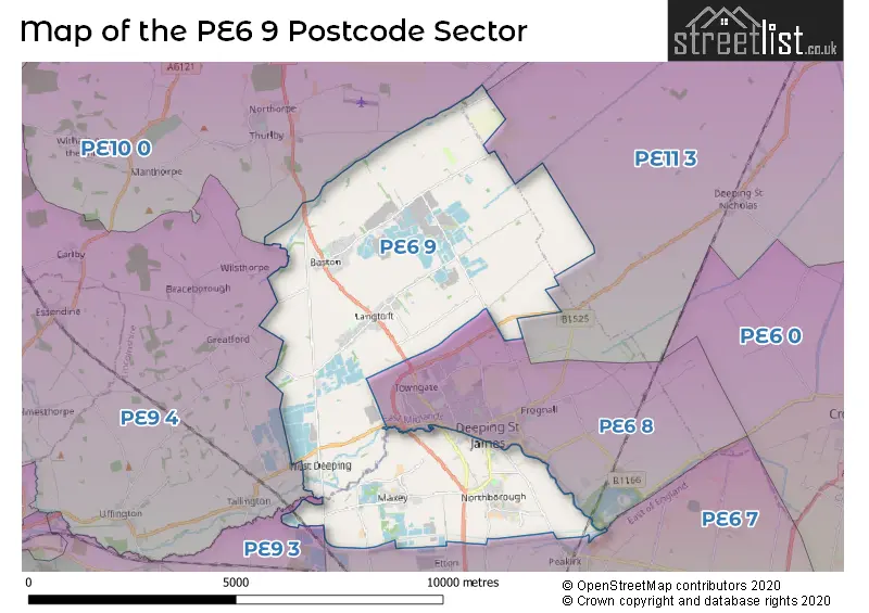
The PE6 9 postcode sector stands on the Cambridgeshire and Lincolnshire border.
Did you know? According to the 2021 Census, the PE6 9 postcode sector is home to a bustling 6,497 residents!
Given that each sector allows for 400 unique postcode combinations. Letters C, I, K, M, O and V are not allowed in the last two letters of a postcode. With 167 postcodes already in use, this leaves 233 units available.
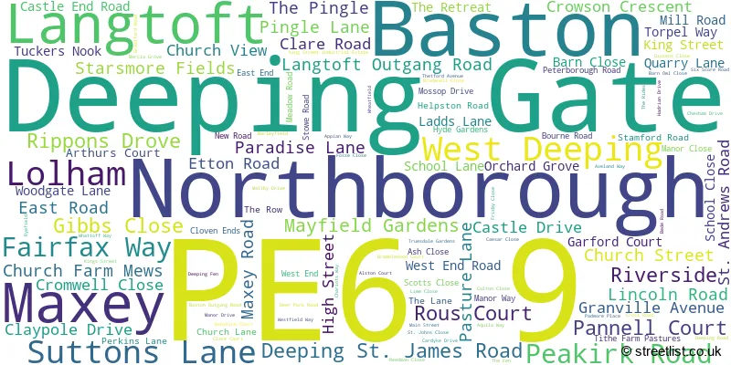
The largest settlement in the PE6 9 postal code is Langtoft followed by Baston, and Northborough.
The PE6 9 Postcode shares a border with PE6 7 (Eye, Glinton, Newborough), PE6 8 (Market Deeping, Deeping St. James), PE9 3 (Ketton, Easton On The Hill, Barnack), PE9 4 (Tallington, Ryhall, Great Casterton), PE10 0 (BOURNE, Morton, Thurlby) and PE11 3 (SPALDING, Pinchbeck, Deeping St. Nicholas).
The sector is within the post town of PETERBOROUGH.
PE6 9 is a postcode sector within the PE6 postcode district which is within the PE Peterborough postcode area.
The Royal Mail delivery office for the PE6 9 postal sector is the Peterborough Postal Delivery Office and Market Deeping Delivery Office.
The area of the PE6 9 postcode sector is 20.44 square miles which is 52.93 square kilometres or 13,080.44 square acres.
Waterways within the PE6 9 postcode sector include the River Welland.

Map of the PE6 9 Postcode Sector
Explore the PE6 9 postcode sector by using our free interactive map.
| P | E | 6 | - | 9 | X | X |
| P | E | 6 | Space | 9 | Letter | Letter |
Official List of Streets
Langtoft (39 Streets)
Baston (35 Streets)
Maxey (18 Streets)
Northborough (19 Streets)
West Deeping (5 Streets)
Unofficial Streets or Alternative Spellings
Pode Hole
NORTH DROVEPeakirk
DEEPING ROAD ASHFIELDS ATTERS COURTYARD BLACK DROVE BLIND LANE BRIDGEFOOT BRIDGEGATE LANE COUNTER DRAIN DROVE GRAVEL ROAD GREEN CROFT GREEN LANE HACKS DROVE KATES BRIDGE LANGTOFT DRAIN ROAD LINCOLN ROAD CYCLE PATH LONG WALK MARKET DEEPING BYPASS NINE BRIDGES NORTH MEADOW ROAD OLD LINCOLN ROAD PANNEL COURT PERKING LANE PETERBOROUGH ROAD CYCLE PATH REEDMANS CLOSE SHARPES ROAD SIXSCORE BRIDGE TRUEDALE GARDENS WILSTHORPE ROADHelpston
MAXEY ROADMarket Deeping
NORTHFIELD ROAD EAST STAMFORD ROADBarholm
STOWE ROADGreatford
BASTON ROADWeather Forecast for PE6 9
Press Button to Show Forecast for Langtoft
| Time Period | Icon | Description | Temperature | Rain Probability | Wind |
|---|---|---|---|---|---|
| 00:00 to 03:00 | Cloudy | 11.0°C (feels like 9.0°C) | 11.00% | SW 11 mph | |
| 03:00 to 06:00 | Partly cloudy (night) | 9.0°C (feels like 7.0°C) | 5.00% | SW 9 mph | |
| 06:00 to 09:00 | Sunny day | 9.0°C (feels like 7.0°C) | 3.00% | SSW 9 mph | |
| 09:00 to 12:00 | Partly cloudy (day) | 13.0°C (feels like 11.0°C) | 3.00% | SW 11 mph | |
| 12:00 to 15:00 | Partly cloudy (day) | 16.0°C (feels like 14.0°C) | 5.00% | SSW 11 mph | |
| 15:00 to 18:00 | Partly cloudy (day) | 17.0°C (feels like 15.0°C) | 9.00% | SSW 9 mph | |
| 18:00 to 21:00 | Cloudy | 16.0°C (feels like 15.0°C) | 12.00% | SSW 4 mph | |
| 21:00 to 00:00 | Partly cloudy (night) | 12.0°C (feels like 10.0°C) | 5.00% | SSE 7 mph |
Press Button to Show Forecast for Langtoft
| Time Period | Icon | Description | Temperature | Rain Probability | Wind |
|---|---|---|---|---|---|
| 00:00 to 03:00 | Partly cloudy (night) | 10.0°C (feels like 9.0°C) | 6.00% | S 7 mph | |
| 03:00 to 06:00 | Cloudy | 8.0°C (feels like 7.0°C) | 8.00% | SSE 4 mph | |
| 06:00 to 09:00 | Partly cloudy (day) | 10.0°C (feels like 9.0°C) | 13.00% | SSE 7 mph | |
| 09:00 to 12:00 | Cloudy | 14.0°C (feels like 13.0°C) | 10.00% | SSE 7 mph | |
| 12:00 to 15:00 | Cloudy | 15.0°C (feels like 14.0°C) | 17.00% | SE 7 mph | |
| 15:00 to 18:00 | Partly cloudy (day) | 16.0°C (feels like 15.0°C) | 11.00% | SE 7 mph | |
| 18:00 to 21:00 | Light rain shower (day) | 14.0°C (feels like 14.0°C) | 34.00% | S 7 mph | |
| 21:00 to 00:00 | Cloudy | 11.0°C (feels like 10.0°C) | 7.00% | SE 7 mph |
Schools and Places of Education Within the PE6 9 Postcode Sector
Baston CE Primary School
Voluntary controlled school
103a Main Street, Peterborough, Lincolnshire, PE6 9PB
Head: Mrs Amy Forster
Ofsted Rating: Good
Inspection: 2018-02-06 (2279 days ago)
Website: Visit Baston CE Primary School Website
Phone: 01778560430
Number of Pupils: 181
Langtoft Primary School
Community school
Manor Close, Peterborough, Cambridgeshire, PE6 9NB
Head: Mrs Becky Wood
Ofsted Rating: Good
Inspection: 2023-05-11 (359 days ago)
Website: Visit Langtoft Primary School Website
Phone: 01778343419
Number of Pupils: 193
House Prices in the PE6 9 Postcode Sector
| Type of Property | 2018 Average | 2018 Sales | 2017 Average | 2017 Sales | 2016 Average | 2016 Sales | 2015 Average | 2015 Sales |
|---|---|---|---|---|---|---|---|---|
| Detached | £333,216 | 67 | £363,816 | 73 | £339,930 | 59 | £297,525 | 99 |
| Semi-Detached | £222,016 | 30 | £224,617 | 38 | £193,440 | 39 | £187,000 | 26 |
| Terraced | £181,225 | 10 | £175,562 | 8 | £194,225 | 11 | £164,349 | 7 |
| Flats | £95,000 | 1 | £142,000 | 1 | £0 | 0 | £0 | 0 |
Important Postcodes PE6 9 in the Postcode Sector
PE6 9BN is the postcode for Northborough Primary School, Church Street, and Northborough Primary School, Church Street, Northborough
PE6 9NB is the postcode for LANGTOFT PRIMARY SCHOOL, MANOR CLOSE, LANGTOFT, Langtoft Primary School, Manor Close, and Langtoft Cp School, Manor Close
PE6 9PB is the postcode for Baston C E Primary School, 103a Main Street
| The PE6 9 Sector is within these Local Authorities |
|
|---|---|
| The PE6 9 Sector is within these Counties |
|
| The PE6 9 Sector is within these Water Company Areas |
|