The PR8 2 postcode sector is within the county of Merseyside.
Did you know? According to the 2021 Census, the PR8 2 postcode sector is home to a bustling 8,542 residents!
Given that each sector allows for 400 unique postcode combinations. Letters C, I, K, M, O and V are not allowed in the last two letters of a postcode. With 242 postcodes already in use, this leaves 158 units available.
The largest settlement in the PR8 2 postal code is SOUTHPORT followed by Ainsdale, and Birkdale.
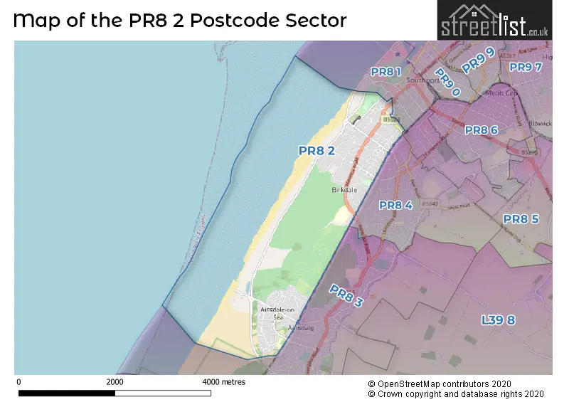
The PR8 2 Postcode shares a border with PR8 1 (SOUTHPORT), PR8 3 (SOUTHPORT, Ainsdale) and PR8 4 (SOUTHPORT).
The sector is within the post town of SOUTHPORT.
PR8 2 is a postcode sector within the PR8 postcode district which is within the PR Preston postcode area.
The Royal Mail delivery office for the PR8 2 postal sector is the Southport Delivery Office.
The area of the PR8 2 postcode sector is 3.78 square miles which is 9.79 square kilometres or 2,418.77 square acres.

Map of the PR8 2 Postcode Sector
Explore the PR8 2 postcode sector by using our free interactive map.
| P | R | 8 | - | 2 | X | X |
| P | R | 8 | Space | 2 | Letter | Letter |
Official List of Streets
SOUTHPORT (125 Streets)
Ainsdale (4 Streets)
Unofficial Streets or Alternative Spellings
SOUTHPORT
BURNLEY ROAD ESPLANADE LYONS ROAD MARINE DRIVE UPPER AUGHTON ROAD CANTERBURY CLOSE CHILTERN ROAD CHURCHFIELDS DUNE PATH NORTH OXFORD COURT PINFOLD PATH PRIORY MEWS ROYAL PARK SAINT VINCENTS WAY THE PROMENADE VELVET TRAIL WINDSOR COURTBirkdale
NELSON COURTAinsdale
COASTAL ROAD LIVERPOOL ROAD STATION ROADWeather Forecast for PR8 2
Press Button to Show Forecast for The Royal Birkdale Golf Club
| Time Period | Icon | Description | Temperature | Rain Probability | Wind |
|---|---|---|---|---|---|
| 18:00 to 21:00 | Cloudy | 8.0°C (feels like 5.0°C) | 9.00% | NE 11 mph | |
| 21:00 to 00:00 | Cloudy | 6.0°C (feels like 3.0°C) | 11.00% | E 9 mph |
Press Button to Show Forecast for The Royal Birkdale Golf Club
| Time Period | Icon | Description | Temperature | Rain Probability | Wind |
|---|---|---|---|---|---|
| 00:00 to 03:00 | Cloudy | 6.0°C (feels like 3.0°C) | 5.00% | E 7 mph | |
| 03:00 to 06:00 | Clear night | 4.0°C (feels like 2.0°C) | 2.00% | ENE 7 mph | |
| 06:00 to 09:00 | Sunny day | 4.0°C (feels like 1.0°C) | 2.00% | ENE 9 mph | |
| 09:00 to 12:00 | Partly cloudy (day) | 8.0°C (feels like 6.0°C) | 6.00% | ENE 9 mph | |
| 12:00 to 15:00 | Cloudy | 10.0°C (feels like 9.0°C) | 18.00% | ENE 7 mph | |
| 15:00 to 18:00 | Overcast | 9.0°C (feels like 7.0°C) | 19.00% | NNE 9 mph | |
| 18:00 to 21:00 | Cloudy | 9.0°C (feels like 7.0°C) | 7.00% | NE 9 mph | |
| 21:00 to 00:00 | Cloudy | 7.0°C (feels like 5.0°C) | 10.00% | ENE 9 mph |
Press Button to Show Forecast for The Royal Birkdale Golf Club
| Time Period | Icon | Description | Temperature | Rain Probability | Wind |
|---|---|---|---|---|---|
| 00:00 to 03:00 | Cloudy | 6.0°C (feels like 3.0°C) | 4.00% | NE 7 mph | |
| 03:00 to 06:00 | Cloudy | 5.0°C (feels like 2.0°C) | 4.00% | NNE 9 mph | |
| 06:00 to 09:00 | Cloudy | 6.0°C (feels like 3.0°C) | 7.00% | N 9 mph | |
| 09:00 to 12:00 | Cloudy | 8.0°C (feels like 5.0°C) | 8.00% | NNW 11 mph | |
| 12:00 to 15:00 | Cloudy | 9.0°C (feels like 6.0°C) | 9.00% | NW 13 mph | |
| 15:00 to 18:00 | Sunny day | 10.0°C (feels like 7.0°C) | 6.00% | WNW 13 mph | |
| 18:00 to 21:00 | Sunny day | 10.0°C (feels like 7.0°C) | 2.00% | W 11 mph | |
| 21:00 to 00:00 | Clear night | 8.0°C (feels like 6.0°C) | 1.00% | SW 11 mph |
Press Button to Show Forecast for The Royal Birkdale Golf Club
| Time Period | Icon | Description | Temperature | Rain Probability | Wind |
|---|---|---|---|---|---|
| 00:00 to 03:00 | Clear night | 7.0°C (feels like 5.0°C) | 1.00% | SSW 9 mph | |
| 03:00 to 06:00 | Partly cloudy (night) | 6.0°C (feels like 3.0°C) | 2.00% | SSE 9 mph | |
| 06:00 to 09:00 | Cloudy | 6.0°C (feels like 3.0°C) | 7.00% | SSE 13 mph | |
| 09:00 to 12:00 | Cloudy | 10.0°C (feels like 7.0°C) | 6.00% | SSE 13 mph | |
| 12:00 to 15:00 | Cloudy | 13.0°C (feels like 10.0°C) | 7.00% | S 16 mph | |
| 15:00 to 18:00 | Cloudy | 13.0°C (feels like 10.0°C) | 9.00% | S 16 mph | |
| 18:00 to 21:00 | Partly cloudy (day) | 13.0°C (feels like 10.0°C) | 6.00% | SSE 13 mph | |
| 21:00 to 00:00 | Clear night | 11.0°C (feels like 8.0°C) | 3.00% | SSE 13 mph |
Press Button to Show Forecast for The Royal Birkdale Golf Club
| Time Period | Icon | Description | Temperature | Rain Probability | Wind |
|---|---|---|---|---|---|
| 00:00 to 03:00 | Partly cloudy (night) | 9.0°C (feels like 6.0°C) | 3.00% | SE 13 mph | |
| 03:00 to 06:00 | Partly cloudy (night) | 8.0°C (feels like 5.0°C) | 3.00% | SE 11 mph | |
| 06:00 to 09:00 | Sunny day | 9.0°C (feels like 6.0°C) | 2.00% | ESE 13 mph | |
| 09:00 to 12:00 | Partly cloudy (day) | 13.0°C (feels like 10.0°C) | 2.00% | ESE 16 mph | |
| 12:00 to 15:00 | Partly cloudy (day) | 15.0°C (feels like 11.0°C) | 12.00% | SE 16 mph | |
| 15:00 to 18:00 | Cloudy | 15.0°C (feels like 13.0°C) | 8.00% | SE 13 mph | |
| 18:00 to 21:00 | Partly cloudy (day) | 15.0°C (feels like 13.0°C) | 6.00% | ESE 11 mph | |
| 21:00 to 00:00 | Cloudy | 12.0°C (feels like 10.0°C) | 6.00% | ESE 11 mph |
Schools and Places of Education Within the PR8 2 Postcode Sector
Greenbank High School
Academy converter
Hastings Road, Southport, Merseyside, PR8 2LT
Head: Ms Davina Aspinall
Ofsted Rating: Good
Inspection: 2022-10-12 (562 days ago)
Website: Visit Greenbank High School Website
Phone: 01704567591
Number of Pupils: 1037
Merefield School
Community special school
Westminster Drive, Southport, Merseyside, PR8 2QZ
Head: Joanne Sharpe
Ofsted Rating: Outstanding
Inspection: 2019-06-05 (1787 days ago)
Website: Visit Merefield School Website
Phone: 01704577163
Number of Pupils: 104
Shoreside Primary School
Academy sponsor led
Westminster Drive, Southport, , PR8 2QZ
Head: Sarah Knipe
Ofsted Rating: Good
Inspection: 2023-04-26 (366 days ago)
Website: Visit Shoreside Primary School Website
Phone: 01704576040
Number of Pupils: 200
House Prices in the PR8 2 Postcode Sector
| Type of Property | 2018 Average | 2018 Sales | 2017 Average | 2017 Sales | 2016 Average | 2016 Sales | 2015 Average | 2015 Sales |
|---|---|---|---|---|---|---|---|---|
| Detached | £443,116 | 84 | £425,307 | 97 | £408,817 | 88 | £380,864 | 77 |
| Semi-Detached | £320,711 | 14 | £298,636 | 11 | £353,750 | 12 | £251,250 | 8 |
| Terraced | £236,000 | 4 | £264,500 | 9 | £244,150 | 13 | £197,813 | 8 |
| Flats | £162,397 | 74 | £182,007 | 100 | £160,402 | 111 | £155,673 | 96 |
Important Postcodes PR8 2 in the Postcode Sector
PR8 2AD is the postcode for The Grange Surgery, 41 York Road
PR8 2HH is the postcode for Head Quarters and General Register Office, Smedley Hydro, Trafalgar Road, and Office for National Statistics, Smedley Hydro, Trafalgar Road
PR8 2LT is the postcode for Greenbank Academy, Hastings Road
PR8 2PJ is the postcode for Ainsdale Hope Centre, Sandringham Road
PR8 2QB is the postcode for PINEWOOD WORKSHOP, Ainsdale Discovery Centre, Sefton Coast & Countryside Service
PR8 2QZ is the postcode for Merefield School, Westminster Drive
PR8 2TQ is the postcode for Shoreside School, Westminster Drive
| The PR8 2 Sector is within these Local Authorities |
|
|---|---|
| The PR8 2 Sector is within these Counties |
|
| The PR8 2 Sector is within these Water Company Areas |
|