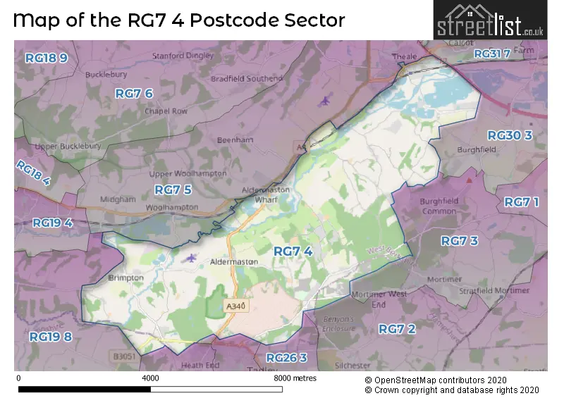
The RG7 4 postcode sector stands on the Berkshire and Hampshire border.
Did you know? According to the 2021 Census, the RG7 4 postcode sector is home to a bustling 3,457 residents!
Given that each sector allows for 400 unique postcode combinations. Letters C, I, K, M, O and V are not allowed in the last two letters of a postcode. With 223 postcodes already in use, this leaves 177 units available.
The largest settlement in the RG7 4 postal code is Aldermaston followed by Theale, and Sulhamstead.
The RG7 4 Postcode shares a border with RG7 3 (Burghfield Common, Mortimer Common, Mortimer), RG19 8 (Greenham, Headley, Crookham Common), RG26 3 (TADLEY, Pamber Heath, Pamber Green), RG31 7 (Calcot), RG7 2 (Silchester, Stratfield Saye, Beech Hill), RG7 5 (Theale, Beenham, Woolhampton), RG26 4 (TADLEY), RG26 5 (Bramley, Baughurst, Little London) and RG30 3 (READING, Burghfield, Pingewood).
The sector is within the post town of READING.
RG7 4 is a postcode sector within the RG26 postcode district which is within the RG Reading postcode area.
The Royal Mail delivery office for the RG7 4 postal sector is the Tadley Delivery Office.
The area of the RG7 4 postcode sector is 17.20 square miles which is 44.56 square kilometres or 11,010.86 square acres.
The RG7 4 postcode sector is crossed by the M4 motorway.
Waterways within the RG7 4 postcode sector include the Kennet and Avon Canal, Kennet & Avon Canal, River Enborne, Padworth Lock.

Map of the RG7 4 Postcode Sector
Explore the RG7 4 postcode sector by using our free interactive map.
| R | G | 7 | - | 4 | X | X |
| R | G | 7 | Space | 4 | Letter | Letter |
Official List of Streets
Aldermaston (25 Streets)
Theale (8 Streets)
Brimpton (12 Streets)
Padworth (12 Streets)
Sulhamstead (10 Streets)
Brimpton Common (2 Streets)
Ufton Nervet (7 Streets)
Padworth Common (9 Streets)
Lower Padworth (2 Streets)
Unofficial Streets or Alternative Spellings
Theale
FLETCHER COURT MYTON WALKBeenham
BATH ROAD CLAY LANE LAMBDENS HILLBurghfield Common
ASH LANE HOLLYBUSH LANEBurghfield
SULHAMSTEAD ROADSilchester
BENYON ROAD SOKE ROADBaughurst
BRIMPTON ROAD INHURST LANE STOKES LANEWeather Forecast for RG7 4
Press Button to Show Forecast for Reading F.C.
| Time Period | Icon | Description | Temperature | Rain Probability | Wind |
|---|---|---|---|---|---|
| 03:00 to 06:00 | Heavy rain | 11.0°C (feels like 9.0°C) | 72.00% | N 11 mph | |
| 06:00 to 09:00 | Light rain | 11.0°C (feels like 9.0°C) | 56.00% | N 9 mph | |
| 09:00 to 12:00 | Light rain | 12.0°C (feels like 12.0°C) | 53.00% | NE 7 mph | |
| 12:00 to 15:00 | Heavy rain | 14.0°C (feels like 14.0°C) | 72.00% | WSW 4 mph | |
| 15:00 to 18:00 | Overcast | 15.0°C (feels like 15.0°C) | 13.00% | W 7 mph | |
| 18:00 to 21:00 | Light rain | 13.0°C (feels like 11.0°C) | 42.00% | W 11 mph | |
| 21:00 to 00:00 | Overcast | 11.0°C (feels like 9.0°C) | 16.00% | W 11 mph |
Press Button to Show Forecast for Reading F.C.
| Time Period | Icon | Description | Temperature | Rain Probability | Wind |
|---|---|---|---|---|---|
| 00:00 to 03:00 | Light rain | 10.0°C (feels like 8.0°C) | 43.00% | W 11 mph | |
| 03:00 to 06:00 | Overcast | 10.0°C (feels like 7.0°C) | 20.00% | W 11 mph | |
| 06:00 to 09:00 | Cloudy | 10.0°C (feels like 7.0°C) | 19.00% | WSW 11 mph | |
| 09:00 to 12:00 | Light rain | 11.0°C (feels like 8.0°C) | 45.00% | WSW 13 mph | |
| 12:00 to 15:00 | Cloudy | 13.0°C (feels like 10.0°C) | 17.00% | WSW 13 mph | |
| 15:00 to 18:00 | Cloudy | 13.0°C (feels like 11.0°C) | 13.00% | WSW 13 mph | |
| 18:00 to 21:00 | Partly cloudy (day) | 13.0°C (feels like 11.0°C) | 5.00% | WSW 9 mph | |
| 21:00 to 00:00 | Partly cloudy (night) | 10.0°C (feels like 8.0°C) | 3.00% | WSW 7 mph |
Press Button to Show Forecast for Reading F.C.
| Time Period | Icon | Description | Temperature | Rain Probability | Wind |
|---|---|---|---|---|---|
| 00:00 to 03:00 | Clear night | 8.0°C (feels like 6.0°C) | 2.00% | SW 7 mph | |
| 03:00 to 06:00 | Clear night | 6.0°C (feels like 5.0°C) | 1.00% | SW 4 mph | |
| 06:00 to 09:00 | Sunny day | 8.0°C (feels like 6.0°C) | 5.00% | SSW 4 mph | |
| 09:00 to 12:00 | Partly cloudy (day) | 13.0°C (feels like 11.0°C) | 7.00% | S 7 mph | |
| 12:00 to 15:00 | Cloudy | 16.0°C (feels like 14.0°C) | 12.00% | S 9 mph | |
| 15:00 to 18:00 | Partly cloudy (day) | 16.0°C (feels like 14.0°C) | 13.00% | S 9 mph | |
| 18:00 to 21:00 | Cloudy | 15.0°C (feels like 13.0°C) | 11.00% | SSE 7 mph | |
| 21:00 to 00:00 | Partly cloudy (night) | 11.0°C (feels like 10.0°C) | 11.00% | SSE 7 mph |
Press Button to Show Forecast for Reading F.C.
| Time Period | Icon | Description | Temperature | Rain Probability | Wind |
|---|---|---|---|---|---|
| 00:00 to 03:00 | Partly cloudy (night) | 9.0°C (feels like 8.0°C) | 9.00% | SE 4 mph | |
| 03:00 to 06:00 | Partly cloudy (night) | 8.0°C (feels like 7.0°C) | 7.00% | SE 4 mph | |
| 06:00 to 09:00 | Cloudy | 9.0°C (feels like 8.0°C) | 10.00% | SSE 4 mph | |
| 09:00 to 12:00 | Cloudy | 13.0°C (feels like 12.0°C) | 12.00% | SSE 7 mph | |
| 12:00 to 15:00 | Cloudy | 15.0°C (feels like 14.0°C) | 14.00% | SE 7 mph | |
| 15:00 to 18:00 | Cloudy | 15.0°C (feels like 13.0°C) | 15.00% | S 9 mph | |
| 18:00 to 21:00 | Cloudy | 14.0°C (feels like 13.0°C) | 12.00% | SW 7 mph | |
| 21:00 to 00:00 | Cloudy | 11.0°C (feels like 11.0°C) | 9.00% | SW 4 mph |
Schools and Places of Education Within the RG7 4 Postcode Sector
Aldermaston C.E. Primary School
Voluntary controlled school
Wasing Lane, Reading, , RG7 4LX
Head: Mrs Melanie Higgs
Ofsted Rating: Good
Inspection: 2023-05-24 (344 days ago)
Website: Visit Aldermaston C.E. Primary School Website
Phone: 01189713362
Number of Pupils: 122
Brimpton C.E. Primary School
Voluntary controlled school
Brimpton Lane, Reading, Berkshire, RG7 4TL
Head: Heidi Davies
Ofsted Rating: Good
Inspection: 2023-10-12 (203 days ago)
Website: Visit Brimpton C.E. Primary School Website
Phone: 01189712311
Number of Pupils: 60
Sulhamstead and Ufton Nervet School
Voluntary aided school
Church Lane, Reading, Berkshire, RG7 4HH
Head: Mrs Melissa Whitaker
Ofsted Rating: Good
Inspection: 2022-10-12 (568 days ago)
Website: Visit Sulhamstead and Ufton Nervet School Website
Phone: 01189832223
Number of Pupils: 103
House Prices in the RG7 4 Postcode Sector
| Type of Property | 2018 Average | 2018 Sales | 2017 Average | 2017 Sales | 2016 Average | 2016 Sales | 2015 Average | 2015 Sales |
|---|---|---|---|---|---|---|---|---|
| Detached | £680,498 | 22 | £1,051,917 | 15 | £681,042 | 24 | £510,239 | 27 |
| Semi-Detached | £444,545 | 10 | £489,545 | 11 | £383,550 | 10 | £359,882 | 17 |
| Terraced | £341,278 | 18 | £313,750 | 16 | £353,200 | 20 | £260,468 | 16 |
| Flats | £224,500 | 2 | £223,333 | 3 | £215,750 | 2 | £205,600 | 3 |
Important Postcodes RG7 4 in the Postcode Sector
RG7 4AQ is the postcode for Driver & Vehicle Licensing Agency, Theale House, Brunel Road
RG7 4BQ is the postcode for Unit 7, Ely Road
RG7 4DX is the postcode for WHITE HOUSE, Thames Valley Police, Sulhamstead, PSTC, Thames Valley Police, Sulhamstead, FIRING RANGE, Thames Valley Police, Sulhamstead, and TEACHING BLOCK, Thames Valley Police, Sulhamstead
RG7 4HH is the postcode for Sulhamstead and Ufton Nervet Primary School, Church Lane
RG7 4LX is the postcode for Aldermaston C of E School, Wasing Lane
RG7 4TL is the postcode for Brimpton C E Primary School, Brimpton Lane
| The RG7 4 Sector is within these Local Authorities |
|
|---|---|
| The RG7 4 Sector is within these Counties |
|
| The RG7 4 Sector is within these Water Company Areas |
|