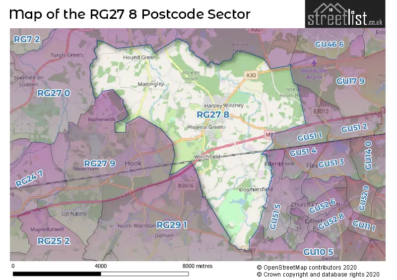
The RG27 8 postcode sector is within the county of Hampshire.
Did you know? According to the 2021 Census, the RG27 8 postcode sector is home to a bustling 7,597 residents!
Given that each sector allows for 400 unique postcode combinations. Letters C, I, K, M, O and V are not allowed in the last two letters of a postcode. With 288 postcodes already in use, this leaves 112 units available.
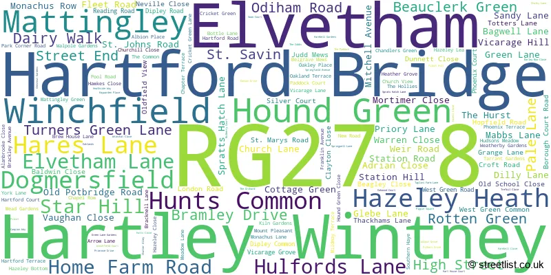
The largest settlement in the RG27 8 postal code is Hartley Wintney followed by Winchfield, and Dogmersfield.
The RG27 8 Postcode shares a border with GU10 5 (Crondall, Bentley, Ewshot), GU17 9 (Blackwater), GU51 5 (FLEET, Crookham Village, Church Crookham), RG27 0 (Sherfield-on-Loddon, Eversley, Heckfield), RG27 9 (HOOK, Rotherwick, Newnham), RG29 1 (Odiham, North Warnborough, South Warnborough) and GU51 1 (FLEET).
The sector is within the post town of HOOK.
RG27 8 is a postcode sector within the RG27 postcode district which is within the RG Reading postcode area.
The Royal Mail delivery office for the RG27 8 postal sector is the Hook Delivery Office.
The area of the RG27 8 postcode sector is 17.86 square miles which is 46.27 square kilometres or 11,432.69 square acres.
The RG27 8 postcode sector is crossed by the M3 motorway.
Waterways within the RG27 8 postcode sector include the Basingstoke Canal.

Map of the RG27 8 Postcode Sector
Explore the RG27 8 postcode sector by using our free interactive map.
| R | G | 2 | 7 | - | 8 | X | X |
| R | G | 2 | 7 | Space | 8 | Letter | Letter |
Official List of Streets
Hartley Wintney (118 Streets)
Winchfield (10 Streets)
Mattingley (4 Streets)
Dogmersfield (6 Streets)
Elvetham (4 Streets)
Unofficial Streets or Alternative Spellings
Crookham Village
PILCOT ROAD STROUD LANEOdiham
BAGWELL LANE ODIHAM ROADCrondall
FARNHAM ROADBramshill
PLOUGH LANERotherwick
COWFOLD LANE GREEN LANE HOOK ROADWeather Forecast for RG27 8
Press Button to Show Forecast for West Green House
| Time Period | Icon | Description | Temperature | Rain Probability | Wind |
|---|---|---|---|---|---|
| 00:00 to 03:00 | Clear night | 9.0°C (feels like 8.0°C) | 0.00% | NE 4 mph | |
| 03:00 to 06:00 | Clear night | 7.0°C (feels like 6.0°C) | 1.00% | NE 4 mph | |
| 06:00 to 09:00 | Cloudy | 9.0°C (feels like 8.0°C) | 4.00% | NE 2 mph | |
| 09:00 to 12:00 | Sunny day | 13.0°C (feels like 13.0°C) | 0.00% | ENE 2 mph | |
| 12:00 to 15:00 | Sunny day | 17.0°C (feels like 17.0°C) | 0.00% | ENE 2 mph | |
| 15:00 to 18:00 | Partly cloudy (day) | 19.0°C (feels like 18.0°C) | 1.00% | ENE 2 mph | |
| 18:00 to 21:00 | Partly cloudy (day) | 18.0°C (feels like 18.0°C) | 1.00% | ESE 4 mph | |
| 21:00 to 00:00 | Cloudy | 13.0°C (feels like 12.0°C) | 3.00% | SSW 7 mph |
Press Button to Show Forecast for West Green House
| Time Period | Icon | Description | Temperature | Rain Probability | Wind |
|---|---|---|---|---|---|
| 00:00 to 03:00 | Partly cloudy (night) | 10.0°C (feels like 9.0°C) | 1.00% | SSW 4 mph | |
| 03:00 to 06:00 | Cloudy | 9.0°C (feels like 8.0°C) | 4.00% | SSW 4 mph | |
| 06:00 to 09:00 | Sunny day | 11.0°C (feels like 10.0°C) | 3.00% | SW 4 mph | |
| 09:00 to 12:00 | Partly cloudy (day) | 16.0°C (feels like 16.0°C) | 1.00% | SW 2 mph | |
| 12:00 to 15:00 | Cloudy | 19.0°C (feels like 19.0°C) | 5.00% | SE 2 mph | |
| 15:00 to 18:00 | Cloudy | 20.0°C (feels like 20.0°C) | 4.00% | SE 2 mph | |
| 18:00 to 21:00 | Cloudy | 19.0°C (feels like 19.0°C) | 3.00% | SE 2 mph | |
| 21:00 to 00:00 | Cloudy | 13.0°C (feels like 13.0°C) | 4.00% | SSW 4 mph |
Press Button to Show Forecast for West Green House
| Time Period | Icon | Description | Temperature | Rain Probability | Wind |
|---|---|---|---|---|---|
| 00:00 to 03:00 | Cloudy | 11.0°C (feels like 10.0°C) | 4.00% | SSW 4 mph | |
| 03:00 to 06:00 | Cloudy | 10.0°C (feels like 9.0°C) | 4.00% | S 2 mph | |
| 06:00 to 09:00 | Cloudy | 12.0°C (feels like 12.0°C) | 4.00% | ESE 2 mph | |
| 09:00 to 12:00 | Cloudy | 17.0°C (feels like 17.0°C) | 4.00% | E 2 mph | |
| 12:00 to 15:00 | Cloudy | 20.0°C (feels like 19.0°C) | 4.00% | ESE 4 mph | |
| 15:00 to 18:00 | Cloudy | 21.0°C (feels like 20.0°C) | 5.00% | SE 4 mph | |
| 18:00 to 21:00 | Cloudy | 19.0°C (feels like 18.0°C) | 4.00% | SSE 4 mph | |
| 21:00 to 00:00 | Partly cloudy (night) | 14.0°C (feels like 14.0°C) | 1.00% | S 4 mph |
Press Button to Show Forecast for West Green House
| Time Period | Icon | Description | Temperature | Rain Probability | Wind |
|---|---|---|---|---|---|
| 00:00 to 03:00 | Clear night | 12.0°C (feels like 12.0°C) | 0.00% | SSE 4 mph | |
| 03:00 to 06:00 | Clear night | 11.0°C (feels like 10.0°C) | 1.00% | ENE 4 mph | |
| 06:00 to 09:00 | Sunny day | 12.0°C (feels like 12.0°C) | 1.00% | E 4 mph | |
| 09:00 to 12:00 | Sunny day | 18.0°C (feels like 18.0°C) | 0.00% | E 4 mph | |
| 12:00 to 15:00 | Partly cloudy (day) | 21.0°C (feels like 20.0°C) | 2.00% | SE 4 mph | |
| 15:00 to 18:00 | Cloudy | 21.0°C (feels like 20.0°C) | 6.00% | SSE 7 mph | |
| 18:00 to 21:00 | Sunny day | 20.0°C (feels like 19.0°C) | 1.00% | SSE 7 mph | |
| 21:00 to 00:00 | Clear night | 14.0°C (feels like 13.0°C) | 1.00% | SSE 4 mph |
Schools and Places of Education Within the RG27 8 Postcode Sector
Dogmersfield Church of England Primary School
Voluntary aided school
Chatter Alley, Hook, Hampshire, RG27 8SS
Head: Mrs Deborah Nicholass
Ofsted Rating: Good
Inspection: 2020-01-28 (1562 days ago)
Website: Visit Dogmersfield Church of England Primary School Website
Phone: 01252616345
Number of Pupils: 108
Greenfields Junior School
Community school
Green Lane, Hook, Hampshire, RG27 8DQ
Head: Mr Tom May
Ofsted Rating: Good
Inspection: 2022-06-15 (693 days ago)
Website: Visit Greenfields Junior School Website
Phone: 01252843822
Number of Pupils: 288
Oakwood Infant School
Community school
Church Lane, Hook, Hampshire, RG27 8DY
Head: Mr Tom May
Ofsted Rating: Good
Inspection: 2022-07-14 (664 days ago)
Website: Visit Oakwood Infant School Website
Phone: 01252842663
Number of Pupils: 251
House Prices in the RG27 8 Postcode Sector
| Type of Property | 2018 Average | 2018 Sales | 2017 Average | 2017 Sales | 2016 Average | 2016 Sales | 2015 Average | 2015 Sales |
|---|---|---|---|---|---|---|---|---|
| Detached | £786,074 | 47 | £792,518 | 58 | £726,855 | 66 | £734,090 | 62 |
| Semi-Detached | £452,435 | 24 | £460,650 | 30 | £446,048 | 34 | £416,463 | 43 |
| Terraced | £375,162 | 34 | £370,639 | 26 | £394,538 | 32 | £397,279 | 47 |
| Flats | £201,213 | 15 | £304,341 | 22 | £427,941 | 23 | £342,913 | 12 |
Important Postcodes RG27 8 in the Postcode Sector
RG27 8DQ is the postcode for Greenfields Junior School, Green Lane, and GREENFIELDS JUNIOR SCHOOL, GREEN LANE, HARTLEY WINTNEY
RG27 8DY is the postcode for Oakwood School, Church Lane
RG27 8DZ is the postcode for Oakwood Infant School, Church Lane
RG27 8SS is the postcode for Dogmersfield CE (A) Primary School, Chatter Alley
| The RG27 8 Sector is within these Local Authorities |
|
|---|---|
| The RG27 8 Sector is within these Counties |
|
| The RG27 8 Sector is within these Water Company Areas |
|
Tourist Attractions within the RG27 8 Postcode Area
We found 1 visitor attractions within the RG27 postcode area
| West Green House Garden |
|---|
| Gardens |
| Garden |
| View West Green House Garden on Google Maps |