Map of Addison Gardens
| Street Crime (updated 04/05/2024) | ||
|---|---|---|
| Location Note | Central Point of Street - Not Actual Location | |
| MSOA Info | For MSOA E02004761 (Statistical Neighbourhood) | |
| Click Hint | Click on a Circle for a detailed breakdown below map. | |
| Crime Levels |
Green = Very Low Yellow = Low Orange = High Red = Very High |
|
| Postcodes | ||
| Icon | Postcodes for Addison Gardens | |
| Walking Distances | ||
| Distance Info | Green Circle = 10 Minutes Walk (800 metres) | |
About Addison Gardens
Addison Gardens is a street located in the village of Odiham. It uses the postcode RG29 1AS. The street has a length of approximately 142 metres.
The street is publicly maintained which means that the road is adopted and Hampshire is responsible for the repair and upkeep of the highway.
Addison Gardens is located within the Hart District Council's jurisdiction. They provide various services, like refuse collection, and manage council tax collection. It's situated in the South East region of the UK.
Addison Gardens has been assigned the Unique Street Reference Number of 16708705 in the National Street Gazetteer.
Addison Gardens is located within the county of Hampshire, situated in the South East region of the UK. It's 39.51 miles South West from central London., 6.37 miles East from Basingstoke, 13.8 miles South from Reading and 15.82 miles West from Guildford.
Addison Gardens is within the Post Town of HOOK
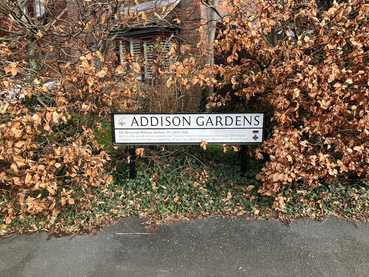
David Caldwell, Addison Gardens, Odiham, Street Sign

Do you know why this road is called Addison Gardens?
What's it like to live here?
Ask the community a question about Addison Gardens.
Do you have any questions, memories to share or know any facts about Addison Gardens? We'd love to know more.
Also on streetlist.co.uk, can you help?
Swing Swang Lane
28th April 2024
I am trying to find out why the lane is named Swing Swang?
It has been known known this since at least 1905 when hedge making contents used to be held here.
Swing Swang is often used to describe a fairground ride. I remember Swing Boats. Were they a bit like this or is Swing Swang another name for swings?
Swing Swangs are also mentioned in connection to orchards. Or were orchards just good places to have swings?
House Sales in Addison Gardens
| Year | High | Low | Average | Sales |
|---|---|---|---|---|
| 2011 | £430,000 | £430,000 | £430,000 | 1 |
| 2015 | £399,950 | £340,000 | £436,650 | 3 |
| 2016 | £478,000 | £480,000 | £481,000 | 3 |
| 2018 | £522,000 | £522,000 | £522,000 | 1 |
| 2019 | £450,000 | £585,000 | £517,500 | 2 |
| 2020 | £545,000 | £545,000 | £545,000 | 1 |
| 2021 | £561,300 | £561,300 | £561,300 | 1 |
| 2023 | £750,000 | £750,000 | £750,000 | 1 |
Contains HM Land Registry data © Crown copyright and database right 2024. This data is licensed under the Open Government Licence v3.0.
Estate Agents near Addison Gardens
| Name | Address | Website |
|---|---|---|
| Strutt & Parker | 82 High Street, Odiham, Hampshire, RG29 1LP | Visit Website |
| McCarthy Holden | 95 High Street, Odiham, RG29 1LA | Visit Website |
| Bridges Estate Agents | 3 Fairholme Parade Station Road Hook RG27 9HE | Visit Website |
We have found 1 postcode for Addison Gardens
Location Details
| Addison Gardens | |
|---|---|

| |
| Latitude | 51.256784 |
| Longitude | -0.934445 |
| OS Easting (X): | 474348 |
| OS Northing (Y): | 151442 |
| OS Grid Reference: | SU743514 |
Neighbourhood Policing |
| Police Force: Hampshire |
 View Neighbourhood Crime and Policing View Neighbourhood Crime and Policing |
| Find a Local Neighbourhood Watch Scheme |
Frequently asked Questions for Addison Gardens
What Council (Local Authority) is Addison Gardens in?
Addison Gardens is located within the local authority area of Hart Council which is a District Council.
What Parish Council is Addison Gardens in?
Addison Gardens is located within the area of Odiham Parish Council.
What Electoral Ward is Addison Gardens in?
Addison Gardens is located within the ward of Odiham.
What County is Addison Gardens in?
Addison Gardens is located within the ceremonial county of Hampshire.
What Constituency is Addison Gardens in?
Addison Gardens is located within the constituency of North East Hampshire.
What Part of the UK is Addison Gardens in?
Addison Gardens is located within the South East (England) region of the United Kingdom.
What County Council area is Addison Gardens in?
Addison Gardens is located within the Hampshire Council area.
What Police Force area is Addison Gardens in?
Addison Gardens is located within the Hampshire Police area.
Roads that have a Junction with Addison Gardens
| Street | Junction Type |
|---|---|
| London Road | junction |
Sunset and Sunrise times for Addison Gardens , RG29 1AS
| Sunrise | 05:17 |
|---|---|
| Sunset | 20:42 |
Latest Weather Conditions for Addison Gardens, RG29 1AS
| Observed at Weather Station: | Odiham 10 May 2024 at 21:00 (1.36 miles away) |
|---|---|
| Current Weather: | Clear night |
| Temperature and Humidity: | 16.4°C (63.7%) |
| Wind Direction and Speed: | E (6 mph) |
Population Statistics
| ONS Area Code | E00116299 |
|---|---|
| ONS Area Name | Self-Sufficient Retirement |
| Average Age | 43.28 |
| Area Population | 1479.00 |
| Male Population | 700.00 (47%) |
| Female Population | 779.00 (53%) |
| Benefit Claimants | 6 (0%) |
| LSOA Code: | E01022889 |
|---|---|
| LSOA Name: | Hart 011C |
| SOA Code: | 5c |
| SOA Name: | |
| MSOA Code: | E02004761 |
| MSOA Name: | Hart 011 |
Nearest Supermarkets
| Tesco Hook Superstore |
|---|
| Station Rd, Hook, RG27 9JE |
| 0345 677 9352 |
| Distance: 1.93 Miles |
| Directions from Addison Gardens to Tesco Hook Superstore |
| Morrisons Fleet |
|---|
| Elvetham Heath, Fleet GU51 1GY |
| 01252 786050 |
| Distance: 4.07 Miles |
| Directions from Addison Gardens to Morrisons Fleet |
| Sainsburys Church Crookham Sandy Lane Local |
|---|
| Queen Elizabeth Barracks, Sandy Lane, Chruch Crookham, Fleet, England, GU52 8LH |
| 1252786277 |
| Distance: 4.11 Miles |
| Directions from Addison Gardens to Sainsburys Church Crookham Sandy Lane Local |
| Waitrose At Fleet South Services |
|---|
| M3 Motorway, Junction 4a/5, Fleet, Hampshire, GU51 1AA |
| 01252 621656 |
| Distance: 4.26 Miles |
| Directions from Addison Gardens to Waitrose At Fleet South Services |
Telephone Information
| Area Code |
|---|
| Area Code: 01256 - Basingstoke |
| Area Code: 01420 - Alton |
| Area Code: 01252 - Aldershot |
Broadband Information
| Speed | Average Speed | Median Speed | Maximum Speed | Next-generation access (NGA) | Number of Connections |
|---|---|---|---|---|---|
| Greater than 2 Mbps | 17.3 | 19.2 | 23 | N | 22 |
Local Government
| Local Council Details |
|---|
| Within the area of Hart |
| Visit the Council's Website |
| Civic Offices, Harlington Way, Fleet, Hants &GU51 4AE |
| Send email |
| Telephone Number: 01252 622122 |
| Local Member of Parliament |
|---|
| Within the Westminster Parliamentary Constituency of North East Hampshire |
| The Member of Parliament is Ranil Jayawardena |
| Details for the MP Ranil Jayawardena on parliament.uk |
| Details for the MP Ranil Jayawardena on theyworkforyou.com |
| In the 2019 General Election Ranil Jayawardena won with a majority of 20,211 the result was Con hold. The total electorate was 78,954 |
| Wards, Parish Councils and County Councils |
|---|
| Ward: Odiham Ward |
| Parish: Odiham Parish Council |
| Ceremonial County: Hampshire |
Nearest Schools
England Primary Schools
Buryfields Infant School
Address: Buryfields Infant School, Buryfields, Odiham, Hook, Hampshire, RG29 1NE
Distance: 0.42 miles
Contact: 01256702667
Mayhill Junior School
Address: Mayhill Junior School, The Bury, Odiham, Hook, Hampshire, RG29 1NB
Distance: 0.36 miles
Contact: 01256702973
Long Sutton Church of England Primary School
Address: Long Sutton Church of England Primary School, Hyde Road, Long Sutton, Hook, Hampshire, RG29 1ST
Distance: 2.52 miles
Contact: 01256862238
England Secondary Schools
Robert May's School
Address: Robert May's School, West Street, Odiham, Hook, Hampshire, RG29 1NA
Distance: 0.83 miles
Contact: 01256702700
Nearest Hospitals
| Odiham Cottage Hospital |
|---|
| Address: Buryfields, Odiham, Hook, RG29 1NE, |
| Independent Sector |
| Southern Health NHS Foundation Trust |
| Telephone: 01256 393600 |
| Distance: 0.67 (miles) |
| Directions from to Odiham Cottage Hospital |
| Fleet Community Hospital |
|---|
| Address: Church Road, Fleet, GU51 4LZ, |
| Independent Sector |
| Southern Health NHS Foundation Trust |
| Telephone: 01252 813800 |
| Distance: 6.87 (miles) |
| Directions from to Fleet Community Hospital |
| Spire Clare Park Hospital |
|---|
| Address: Crondall Lane, Farnham, GU10 5XX, |
| Independent Sector |
| Spire Healthcare |
| Telephone: 01252 850216 |
| Visit Hospital Website |
| Distance: 7 (miles) |
| Directions from to Spire Clare Park Hospital |
Nearest Dentists
Dentists near Addison Gardens
ODIHAM DENTAL CARE
Address: 45B HIGH STREET, ODIHAM, HOOK, HAMPSHIRE, RG29 1LF
Distance: 0.26 miles
Contact: :
KING STREET DENTAL PRACTICE
Address: KING STREET, ODIHAM, HOOK, HAMPSHIRE, RG29 1NJ
Distance: 0.33 miles
Contact: :
ODIHAM DENTAL CENTRE
Address: THE DENTAL CENTRE, ODIHAM, HOOK, HAMPSHIRE, RG29 1QT
Distance: 1.22 miles
Contact: :
HOOK DENTAL
Address: STANLEY HOUSE, LONDON ROAD, HOOK, HAMPSHIRE, RG27 9GA
Distance: 2.15 miles
Contact: :
2 LONDON ROAD (DENTAL PRACTICE)
Address: 2 LONDON ROAD, HOOK, HAMPSHIRE, RG27 9DJ
Distance: 2.17 miles
Contact: :
ZEBON COPSE DENTAL
Address: UNIT 1, 23 FRENCHMANS CREEK, CHURCH CROOKHAM, FLEET, GU52 0YE
Distance: 3.65 miles
Contact: :
Nearest GP Surgeries
Doctors near Addison Gardens
ODIHAM HEALTH CENTRE
Address: DEER PARK VIEW, ODIHAM, HOOK, HAMPSHIRE, RG29 1JY
Distance: 0.32 miles
Contact: tel: 01256 702371
HOOK SURGERY
Address: READING ROAD, HOOK, HAMPSHIRE, RG27 9ED
Distance: 2.39 miles
Contact: :
CRONDALL NEW SURGERY
Address: REDLANDS LANE, CRONDALL, FARNHAM, SURREY, GU10 5RF
Distance: 3.56 miles
Contact: tel: 01252 850292
WHITEWATER HEALTH
Address: THE SURGERY, 1 CHAPTER TERRACE, HARTLEY WINTNEY, HOOK, HAMPSHIRE, RG27 8QJ
Distance: 3.72 miles
Contact: tel: 01252 842087
RICHMOND SURGERY
Address: RICHMOND CLOSE, FLEET, HAMPSHIRE, GU52 7US
Distance: 4.13 miles
Contact: tel: 01252 811466
RICHMOND SURGERY - COVID LOCAL VACCINATION SERVICE
Address: RICHMOND CLOSE, FLEET, GU52 7US
Distance: 4.13 miles
Contact: :
Nearest Dispensing Chemists
Pharmacies near Addison Gardens
TOUCHWOOD PHARMACY
Address: 138 HIGH STREET, ODIHAM, HOOK, RG29 1LT
Distance: 0.36 miles
Contact: tel: 01256 702218
BOOTS
Address: FLAT 2, HOOK PARADE, STATION ROAD, HOOK, HAMPSHIRE, RG27 9HB
Distance: 2.14 miles
Contact: tel: 01256 762497
WHITEWATER PHARMACY
Address: READING ROAD, HOOK, HAMPSHIRE, RG27 9ED
Distance: 2.39 miles
Contact: tel: 07811 261922
WELLBEING PHARMACY
Address: 74 HIGH STREET, HARTLEY WINTNEY, HOOK, RG27 8NY
Distance: 3.77 miles
Contact: tel: 01252 842449
MORRISONS PHARMACY
Address: THE KEY, ELVETHAM HEATH WAY, FLEET, GU51 1HA
Distance: 4.08 miles
Contact: tel: 01252 625821
THE WELLBEING PHARMACY
Address: RICHMOND SURGERY, RICHMOND CLOSE, FLEET, HAMPSHIRE, GU52 7US
Distance: 4.13 miles
Contact: tel: 01252 624363
Nearest Opticians
Opticians near Addison Gardens
BROWN AND WHITE OPTICIANS LTD (HOOK)
Address: BOURNE HOUSE, LONDON ROAD, HOOK, HAMPSHIRE, RG27 9DJ
Distance: 2.17 miles
Contact: :
RICHARD WARD EYECARE (HARTLEY MEWS)
Address: THE OLD BAKEHOUSE, HARTLEY MEWS, HARTLEY WINTNEY, HOOK, HAMPSHIRE, RG27 8NX
Distance: 3.82 miles
Contact: :
BROWN AND WHITE OPTICIANS LTD (FLEET)
Address: 341 FLEET ROAD, FLEET, HAMPSHIRE, GU51 3NT
Distance: 4.14 miles
Contact: :
BAYFIELDS Z LTD - FLEET
Address: 202 FLEET ROAD, FLEET, HAMPSHIRE, GU51 4BY
Distance: 4.21 miles
Contact: :
SPECSAVERS (FLEET)
Address: 231 FLEET ROAD, FLEET, HAMPSHIRE, GU51 3BN
Distance: 4.31 miles
Contact: :
BOOTS OPTICIANS (FLEET)
Address: 23 THE HART SHOPPING CENTRE, FLEET, HAMPSHIRE, GU51 3LA
Distance: 4.35 miles
Contact: :
Transport
Nearest Rail Stations
Hook Station is 1.99 miles away.
Address: Hook station, Station Approach / Road, Hook, Hampshire, RG27 9HS
Hook is situated on the South Western Main Line and is managed by South Western Railway.
Hook Station is staffed on a part time basis.
Winchfield Station is 2.28 miles away.
Address: Winchfield station, Station Road, Winchfield, Hampshire, RG27 8BX
Winchfield is situated on the South Western Main Line and is managed by South Western Railway.
Winchfield Station is staffed on a part time basis.