The RG7 postcode district is a postal district located in the RG Reading postcode area with a population of 36,324 residents according to the 2021 England and Wales Census.
The area of the RG7 postcode district is 73.06 square miles which is 189.23 square kilometres or 46,759.98 acres.
Currently, the RG7 district has about 1472 postcode units spread across 6 geographic postcode sectors.
Given that each sector allows for 400 unique postcode combinations, the district has a capacity of 2,400 postcodes. With 1472 postcodes already in use, this leaves 928 units available.
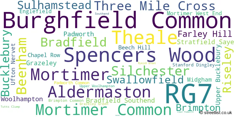
The largest settlement in the RG7 postal code is Burghfield Common followed by Spencers Wood, and Theale.
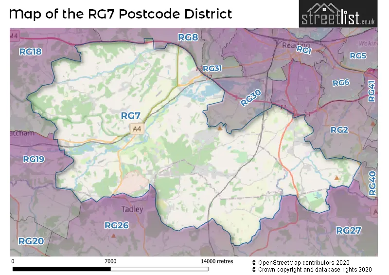
The RG7 Postcode shares a border with RG18 (THATCHAM, Hermitage, Cold Ash), RG2 (READING, Shinfield, Arborfield Green), RG26 (TADLEY, Bramley, Baughurst), RG27 (HOOK, Hartley Wintney, Sherfield-on-Loddon), RG30 (READING, Tilehurst, Burghfield), RG40 (WOKINGHAM, Finchampstead, Finchwood Park) and RG8 (Pangbourne, Goring, Purley On Thames).
In the RG7 postcode district, the primary settlement is Spencers Wood, located in the county of Berkshire, England. Other significant settlements include Three Mile Cross, Swallowfield, Riseley, Farley Hill, and Grazeley, all also in the county of Berkshire. The postal town for this district is Reading.
For the district RG7, we have data on 7 postcode sectors. Here's a breakdown: The sector RG7 1, covers Spencers Wood and Three Mile Cross and Swallowfield and Riseley in Berkshire. The sector RG7 2, covers Silchester and Stratfield Saye in Hampshire. The sector RG7 2, covers Beech Hill in Berkshire. The sector RG7 3, covers Burghfield Common and Mortimer and Mortimer Common in Berkshire. The sector RG7 4, covers Aldermaston and Sulhamstead and Brimpton and Theale in Berkshire. The sector RG7 5, covers Theale and Beenham and Woolhampton in Berkshire. The sector RG7 6, covers Bradfield and Bucklebury and Bradfield Southend and Upper Bucklebury in Berkshire. The sector RG7 8 is non-geographic. It's often designated for PO Boxes, large organisations, or special services.

Map of the RG7 Postcode District
Explore the RG7 postcode district by using our free interactive map.
When it comes to local government, postal geography often disregards political borders. However, for a breakdown in the RG7 District: the district mostly encompasses the West Berkshire (1049 postcodes), followed by the Wokingham (B) area (309 postcodes), followed by the Basingstoke and Deane District (B) area (115 postcodes), followed by the Hart District area (9 postcodes), and finally, the Reading (B) area (3 postcodes).
Recent House Sales in RG7
| Date | Price | Address |
|---|---|---|
| 18/10/2023 | £282,500 | Watermill Court, Woolhampton, Reading, RG7 5RD |
| 06/10/2023 | £505,000 | Hyde End Road, Spencers Wood, Reading, RG7 1DD |
| 14/09/2023 | £365,000 | Worsley Place, Theale, Reading, RG7 5QP |
| 11/09/2023 | £470,000 | Stretton Close, Bradfield Southend, Reading, RG7 6EN |
| 08/09/2023 | £520,000 | Briar Lea Road, Mortimer Common, Reading, RG7 3SA |
| 05/09/2023 | £460,000 | Mallard Way, Aldermaston, Reading, RG7 4US |
| 05/09/2023 | £126,000 | Calleva Park, Aldermaston, Reading, RG7 8SA |
| 01/09/2023 | £730,000 | Mallard Way, Aldermaston, Reading, RG7 4UT |
| 01/09/2023 | £525,000 | Hyde End Road, Spencers Wood, Reading, RG7 1DN |
| 01/09/2023 | £273,000 | Hayes Drive, Three Mile Cross, Reading, RG7 1GB |
Weather Forecast for RG7
Press Button to Show Forecast for Stratfield Saye House
| Time Period | Icon | Description | Temperature | Rain Probability | Wind |
|---|---|---|---|---|---|
| 09:00 to 12:00 | Light rain | 7.0°C (feels like 4.0°C) | 80.00% | ENE 9 mph | |
| 12:00 to 15:00 | Overcast | 10.0°C (feels like 8.0°C) | 11.00% | ENE 9 mph | |
| 15:00 to 18:00 | Cloudy | 12.0°C (feels like 10.0°C) | 11.00% | ENE 9 mph | |
| 18:00 to 21:00 | Cloudy | 10.0°C (feels like 8.0°C) | 47.00% | NE 9 mph | |
| 21:00 to 00:00 | Heavy rain | 9.0°C (feels like 6.0°C) | 89.00% | NNE 11 mph |
Press Button to Show Forecast for Stratfield Saye House
| Time Period | Icon | Description | Temperature | Rain Probability | Wind |
|---|---|---|---|---|---|
| 00:00 to 03:00 | Heavy rain | 8.0°C (feels like 5.0°C) | 92.00% | NNE 11 mph | |
| 03:00 to 06:00 | Heavy rain | 8.0°C (feels like 5.0°C) | 92.00% | NNE 11 mph | |
| 06:00 to 09:00 | Heavy rain | 7.0°C (feels like 4.0°C) | 79.00% | NNW 9 mph | |
| 09:00 to 12:00 | Heavy rain | 8.0°C (feels like 5.0°C) | 81.00% | NW 11 mph | |
| 12:00 to 15:00 | Light rain | 9.0°C (feels like 6.0°C) | 54.00% | WNW 11 mph | |
| 15:00 to 18:00 | Overcast | 11.0°C (feels like 9.0°C) | 13.00% | W 9 mph | |
| 18:00 to 21:00 | Cloudy | 10.0°C (feels like 9.0°C) | 6.00% | WSW 7 mph | |
| 21:00 to 00:00 | Partly cloudy (night) | 8.0°C (feels like 6.0°C) | 2.00% | SW 7 mph |
Press Button to Show Forecast for Stratfield Saye House
| Time Period | Icon | Description | Temperature | Rain Probability | Wind |
|---|---|---|---|---|---|
| 00:00 to 03:00 | Clear night | 6.0°C (feels like 4.0°C) | 1.00% | SW 7 mph | |
| 03:00 to 06:00 | Clear night | 4.0°C (feels like 2.0°C) | 0.00% | SSW 4 mph | |
| 06:00 to 09:00 | Sunny day | 6.0°C (feels like 5.0°C) | 1.00% | S 4 mph | |
| 09:00 to 12:00 | Partly cloudy (day) | 12.0°C (feels like 10.0°C) | 1.00% | S 9 mph | |
| 12:00 to 15:00 | Cloudy | 13.0°C (feels like 11.0°C) | 6.00% | S 11 mph | |
| 15:00 to 18:00 | Sunny day | 14.0°C (feels like 11.0°C) | 1.00% | S 11 mph | |
| 18:00 to 21:00 | Sunny day | 12.0°C (feels like 10.0°C) | 1.00% | S 9 mph | |
| 21:00 to 00:00 | Clear night | 8.0°C (feels like 7.0°C) | 2.00% | SSE 7 mph |
Press Button to Show Forecast for Stratfield Saye House
| Time Period | Icon | Description | Temperature | Rain Probability | Wind |
|---|---|---|---|---|---|
| 00:00 to 03:00 | Clear night | 8.0°C (feels like 6.0°C) | 3.00% | SE 7 mph | |
| 03:00 to 06:00 | Clear night | 8.0°C (feels like 6.0°C) | 2.00% | SE 7 mph | |
| 06:00 to 09:00 | Partly cloudy (day) | 9.0°C (feels like 7.0°C) | 5.00% | SE 7 mph | |
| 09:00 to 12:00 | Sunny day | 13.0°C (feels like 12.0°C) | 4.00% | SE 9 mph | |
| 12:00 to 15:00 | Partly cloudy (day) | 16.0°C (feels like 13.0°C) | 7.00% | SE 11 mph | |
| 15:00 to 18:00 | Cloudy | 16.0°C (feels like 14.0°C) | 8.00% | SSE 11 mph | |
| 18:00 to 21:00 | Sunny day | 14.0°C (feels like 13.0°C) | 6.00% | SE 7 mph | |
| 21:00 to 00:00 | Partly cloudy (night) | 11.0°C (feels like 10.0°C) | 5.00% | SE 7 mph |
Where is the RG7 Postcode District?
The postcode district RG7 is located in the town of Reading. It is situated in close proximity to several nearby towns. To the South West of RG7 is Tadley, which is approximately 3.93 miles away. To the West is Thatcham, located about 7.26 miles from RG7. Basingstoke, positioned to the South, is approximately 9.42 miles away. To the South East is Hook, which is at a distance of 9.74 miles. Wokingham, located to the East, is around 11.23 miles away. Finally, to the North East of RG7 is Henley-on-Thames, which is approximately 12.51 miles away. RG7 is also located roughly 42.35 miles away from the center of London.
The district is within the post town of READING.
The sector has postcodes within the nation of England.
The RG7 Postcode District is covers the following regions.
- Berkshire - Berkshire, Buckinghamshire and Oxfordshire - South East (England)
- North Hampshire - Hampshire and Isle of Wight - South East (England)
| Postcode Sector | Delivery Office |
|---|---|
| RG7 1 | Hook Delivery Office |
| RG7 2 | Tadley Delivery Office |
| RG7 2 | Hook Delivery Office |
| RG7 3 | Hook Delivery Office |
| RG7 3 | Thatcham Delivery Office |
| RG7 4 | Tadley Delivery Office |
| RG7 4 | Thatcham Delivery Office |
| RG7 5 | Thatcham Delivery Office |
| RG7 6 | Southend (reading) Scale Payment Delivery Office |
| RG7 6 | Thatcham Delivery Office |
| RG7 8 | Tadley Delivery Office |
| R | G | 7 | - | X | X | X |
| R | G | 7 | Space | Numeric | Letter | Letter |
Current Monthly Rental Prices
| # Bedrooms | Min Price | Max Price | Avg Price |
|---|---|---|---|
| 1 | £900 | £1,100 | £1,000 |
| 2 | £1,100 | £2,492 | £1,598 |
| 3 | £1,650 | £2,900 | £2,150 |
| 4 | £2,200 | £3,000 | £2,538 |
| 5 | £3,500 | £4,500 | £4,167 |
| 8 | £20,000 | £20,000 | £20,000 |
Current House Prices
| # Bedrooms | Min Price | Max Price | Avg Price |
|---|---|---|---|
| £250,000 | £2,600,000 | £1,335,000 | |
| 1 | £155,000 | £1,500,000 | £285,063 |
| 2 | £159,950 | £800,000 | £305,040 |
| 3 | £120,000 | £1,200,000 | £513,302 |
| 4 | £400,000 | £1,600,000 | £761,739 |
| 5 | £575,000 | £2,650,000 | £1,199,130 |
| 6 | £575,000 | £2,750,000 | £1,574,545 |
| 7 | £1,200,000 | £5,750,000 | £2,737,500 |
| 8 | £2,195,000 | £3,100,000 | £2,498,333 |
| 13 | £1,500,000 | £1,500,000 | £1,500,000 |
Estate Agents who Operate in the RG7 District
| Logo | Name | Brand Name | Address | Contact Number | Total Properties |
|---|---|---|---|---|---|
 | Mortimer | David Cliff | 36 Victoria Road, Mortimer Common, RG7 3SE | 0118 230 6310 | 21 |
 | Burghfield Common | Davis Tate | Reading Road, Burghfield Common, Berkshire, RG7 3BL | 0118 230 1450 | 20 |
 | Burghfield Common | Parkers Burghfield Common | Reading Road Burghfield Common RG7 3EL | 0118 230 3181 | 19 |
 | Spencers Wood | Parkers Estate Agents | Basingstoke Road, Spencers Wood, RG7 1AP | 01805 640517 | 13 |
 | Reading | Whiteknights Estate Agents | Unit 5 Chalfont Court, Lower Earley District Centre, Lower Earley, RG6 5SY | 0118 230 0230 | 12 |
- Aldermaston
- Aldermaston Soke
- Aldermaston Wharf
- Arborfield Garrison
- AWE Aldermaston
- Beech Hill
- Beenham
- Bradfield
- Bramley
- Brimpton Common
- Brimpton
- Bucklebury
- Burghfield Common
- Burghfield
- Chapel Row
- Crookham
- Englefield
- Fair Cross
- Farley Hill
- Frilsham
- Goddard's Green
- Grazeley Green
- Grazeley
- Great Lea Common
- Heckfield
- Lower Padworth
- Midgham Green
- Midgham
- Mortimer
- Mortimer West End
- North Street
- Old Warren
- Padworth Common
- Padworth
- Poundgreen
- Reading
- Riseley
- Ryeish Green
- Sheffield Bottom
- Silchester
- Southend
- Spencers Wood
- Stanford Dingley
- Stratfield Mortimer
- Stratfield Saye
- Stratfield Turgis
- Sulhamstead Abbots
- Sulhamstead Bannister Upper End
- Sulhamstead
- Swallowfield
- Tadley
- Thatcham
- The Slade
- Theale
- Three Ashes
- Three Mile Cross
- Tutts Clump
- Ufton Green
- Ufton Nervet
- Upper Bucklebury
- Upper Woolhampton
- West End Green
- Whitehouse Green
- Woolhampton
- Yattendon
| Type of Property | 2018 Average | 2018 Sales | 2017 Average | 2017 Sales | 2016 Average | 2016 Sales | 2015 Average | 2015 Sales |
|---|---|---|---|---|---|---|---|---|
| Detached | £639,357 | 256 | £623,018 | 260 | £592,975 | 224 | £571,336 | 248 |
| Semi-Detached | £405,007 | 161 | £408,814 | 180 | £394,763 | 141 | £350,599 | 142 |
| Terraced | £327,969 | 123 | £344,810 | 129 | £335,324 | 121 | £269,514 | 112 |
| Flats | £238,825 | 89 | £246,425 | 63 | £242,469 | 94 | £189,099 | 48 |