The WD25 7 postcode sector is within the county of Hertfordshire.
Did you know? According to the 2021 Census, the WD25 7 postcode sector is home to a bustling 9,787 residents!
Given that each sector allows for 400 unique postcode combinations. Letters C, I, K, M, O and V are not allowed in the last two letters of a postcode. With 182 postcodes already in use, this leaves 218 units available.
The largest settlement in the WD25 7 postal code is WATFORD followed by LEAVESDEN , and ABBOTS LANGLEY .
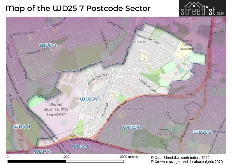
The WD25 7 Postcode shares a border with WD5 0 (ABBOTS LANGLEY , BEDMOND ), WD4 8 (KINGS LANGLEY , HUNTON BRIDGE , ABBOTS LANGLEY ), WD17 4 (WATFORD ), WD24 5 (WATFORD ) and WD25 0 (WATFORD , ABBOTS LANGLEY ).
The sector is within the post town of WATFORD.
WD25 7 is a postcode sector within the WD25 postcode district which is within the WD Watford postcode area.
The Royal Mail delivery office for the WD25 7 postal sector is the Watford (wd) Delivery Office.
The area of the WD25 7 postcode sector is 1.05 square miles which is 2.73 square kilometres or 673.67 square acres.

Map of the WD25 7 Postcode Sector
Explore the WD25 7 postcode sector by using our free interactive map.
| W | D | 2 | 5 | - | 7 | X | X |
| W | D | 2 | 5 | Space | 7 | Letter | Letter |
Official List of Streets
WATFORD (56 Streets)
Leavesden (24 Streets)
Unofficial Streets or Alternative Spellings
Colney Heath
NORTH ORBITAL ROADWATFORD
CART PATH FRASER CRESCENT GREENWOOD DRIVE NORTH APPROACH NORTH WESTERN AVENUE ROSS DRIVE TAIT PLACE THE GLEBEABBOTS LANGLEY,
WOODSIDE ROADABBOTS LANGLEY
COLLEGE ROAD LANGLEY LANE SOUTH WAY AERODROME WAY FP2 GADESIDE GANDERA ASH HAMMER PARADE HILL FARM AVENUE INDUSTRIAL ESTATE KINGSWAY NORTH ORBITAL ROAD MARIAN GARDENS ST MICHAELS DRIVE TIBBS HILL ROADKINGS LANGLEY
ESSEX LANEHunton Bridge
GYPSY LANEWeather Forecast for WD25 7
Press Button to Show Forecast for Garston
| Time Period | Icon | Description | Temperature | Rain Probability | Wind |
|---|---|---|---|---|---|
| 18:00 to 21:00 | Cloudy | 10.0°C (feels like 8.0°C) | 10.00% | ENE 9 mph | |
| 21:00 to 00:00 | Cloudy | 8.0°C (feels like 6.0°C) | 10.00% | E 9 mph |
Press Button to Show Forecast for Garston
| Time Period | Icon | Description | Temperature | Rain Probability | Wind |
|---|---|---|---|---|---|
| 00:00 to 03:00 | Cloudy | 7.0°C (feels like 4.0°C) | 17.00% | ENE 7 mph | |
| 03:00 to 06:00 | Light rain | 6.0°C (feels like 4.0°C) | 50.00% | NE 9 mph | |
| 06:00 to 09:00 | Light rain | 6.0°C (feels like 3.0°C) | 54.00% | NE 9 mph | |
| 09:00 to 12:00 | Overcast | 7.0°C (feels like 4.0°C) | 20.00% | NE 9 mph | |
| 12:00 to 15:00 | Overcast | 9.0°C (feels like 7.0°C) | 13.00% | ENE 9 mph | |
| 15:00 to 18:00 | Overcast | 11.0°C (feels like 9.0°C) | 18.00% | NE 9 mph | |
| 18:00 to 21:00 | Cloudy | 10.0°C (feels like 8.0°C) | 21.00% | NE 11 mph | |
| 21:00 to 00:00 | Light rain | 9.0°C (feels like 6.0°C) | 60.00% | NNE 11 mph |
Press Button to Show Forecast for Garston
| Time Period | Icon | Description | Temperature | Rain Probability | Wind |
|---|---|---|---|---|---|
| 00:00 to 03:00 | Heavy rain | 8.0°C (feels like 5.0°C) | 84.00% | NNE 11 mph | |
| 03:00 to 06:00 | Heavy rain | 8.0°C (feels like 5.0°C) | 88.00% | NNE 11 mph | |
| 06:00 to 09:00 | Heavy rain | 8.0°C (feels like 5.0°C) | 81.00% | WNW 9 mph | |
| 09:00 to 12:00 | Heavy rain | 8.0°C (feels like 5.0°C) | 84.00% | WNW 9 mph | |
| 12:00 to 15:00 | Light rain | 9.0°C (feels like 6.0°C) | 58.00% | WNW 11 mph | |
| 15:00 to 18:00 | Cloudy | 10.0°C (feels like 8.0°C) | 19.00% | W 9 mph | |
| 18:00 to 21:00 | Cloudy | 10.0°C (feels like 8.0°C) | 8.00% | WSW 7 mph | |
| 21:00 to 00:00 | Cloudy | 8.0°C (feels like 7.0°C) | 6.00% | SW 7 mph |
Press Button to Show Forecast for Garston
| Time Period | Icon | Description | Temperature | Rain Probability | Wind |
|---|---|---|---|---|---|
| 00:00 to 03:00 | Partly cloudy (night) | 7.0°C (feels like 5.0°C) | 3.00% | SW 7 mph | |
| 03:00 to 06:00 | Clear night | 6.0°C (feels like 4.0°C) | 1.00% | SSW 4 mph | |
| 06:00 to 09:00 | Sunny day | 7.0°C (feels like 5.0°C) | 1.00% | S 4 mph | |
| 09:00 to 12:00 | Partly cloudy (day) | 11.0°C (feels like 9.0°C) | 1.00% | S 9 mph | |
| 12:00 to 15:00 | Partly cloudy (day) | 14.0°C (feels like 11.0°C) | 3.00% | S 11 mph | |
| 15:00 to 18:00 | Partly cloudy (day) | 15.0°C (feels like 12.0°C) | 4.00% | S 11 mph | |
| 18:00 to 21:00 | Sunny day | 14.0°C (feels like 11.0°C) | 1.00% | S 9 mph | |
| 21:00 to 00:00 | Clear night | 11.0°C (feels like 9.0°C) | 1.00% | SSE 7 mph |
Press Button to Show Forecast for Garston
| Time Period | Icon | Description | Temperature | Rain Probability | Wind |
|---|---|---|---|---|---|
| 00:00 to 03:00 | Clear night | 9.0°C (feels like 8.0°C) | 1.00% | SE 7 mph | |
| 03:00 to 06:00 | Clear night | 9.0°C (feels like 7.0°C) | 2.00% | ESE 7 mph | |
| 06:00 to 09:00 | Sunny day | 9.0°C (feels like 8.0°C) | 4.00% | ESE 7 mph | |
| 09:00 to 12:00 | Partly cloudy (day) | 13.0°C (feels like 11.0°C) | 5.00% | SE 9 mph | |
| 12:00 to 15:00 | Cloudy | 15.0°C (feels like 13.0°C) | 11.00% | SE 9 mph | |
| 15:00 to 18:00 | Cloudy | 16.0°C (feels like 14.0°C) | 14.00% | SE 9 mph | |
| 18:00 to 21:00 | Cloudy | 15.0°C (feels like 14.0°C) | 10.00% | SE 9 mph | |
| 21:00 to 00:00 | Cloudy | 13.0°C (feels like 12.0°C) | 8.00% | ESE 7 mph |
Schools and Places of Education Within the WD25 7 Postcode Sector
Alban Wood Primary School and Nursery
Academy converter
The Brow, Watford, Hertfordshire, WD25 7NX
Head: Mr Jonny Spector
Ofsted Rating: Good
Inspection: 2023-12-14 (134 days ago)
Website: Visit Alban Wood Primary School and Nursery Website
Phone: 01923678240
Number of Pupils: 240
Future Academies Watford
Academy sponsor led
Horseshoe Lane, Watford, Hertfordshire, WD25 7HW
Head: Mr Sam Fox
Ofsted Rating: Requires improvement
Inspection: 2022-06-29 (667 days ago)
Website: Visit Future Academies Watford Website
Phone: 01923672964
Number of Pupils: 1123
Garston Manor School
Community special school
Horseshoe Lane, Watford, Hertfordshire, WD25 7HR
Head: Miss Christine deGraft-Hanson
Ofsted Rating: Good
Inspection: 2022-10-21 (553 days ago)
Website: Visit Garston Manor School Website
Phone: 01923673757
Number of Pupils: 150
Leavesden JMI School
Community school
High Road, Watford, Hertfordshire, WD25 7QZ
Head: Mrs Victoria Lyon
Ofsted Rating: Good
Inspection: 2023-03-29 (394 days ago)
Website: Visit Leavesden JMI School Website
Phone: 01923484340
Number of Pupils: 388
St Catherine of Siena Catholic Primary School
Academy converter
Horseshoe Lane, Watford, Hertfordshire, WD25 7HP
Head: Ms Nicola Kane
Ofsted Rating: Good
Inspection: 2023-09-27 (212 days ago)
Website: Visit St Catherine of Siena Catholic Primary School Website
Phone: 01923676022
Number of Pupils: 269
House Prices in the WD25 7 Postcode Sector
| Type of Property | 2018 Average | 2018 Sales | 2017 Average | 2017 Sales | 2016 Average | 2016 Sales | 2015 Average | 2015 Sales |
|---|---|---|---|---|---|---|---|---|
| Detached | £738,188 | 8 | £514,955 | 11 | £613,762 | 33 | £552,549 | 48 |
| Semi-Detached | £429,291 | 41 | £464,172 | 32 | £455,011 | 48 | £430,739 | 58 |
| Terraced | £390,262 | 38 | £384,542 | 36 | £370,949 | 30 | £326,732 | 49 |
| Flats | £242,182 | 22 | £257,444 | 30 | £232,298 | 25 | £224,005 | 59 |
Important Postcodes WD25 7 in the Postcode Sector
WD25 7HH is the postcode for Watford Woodside Leisure Centre, Horseshoe Lane, and Watford Leisure Centre Woodside, Horseshoe Lane
WD25 7HP is the postcode for St. Catherine of Siena RC School, Horseshoe Lane, and St Catherine of Siena Catholic Primary School, Horseshoe Lane, Garston
WD25 7HR is the postcode for Garston Manor School, Horseshoe Lane
WD25 7HW is the postcode for Francis Combe Academy, Horseshoe Lane
WD25 7NL is the postcode for Sheepcot Medical Centre, 6 Cunningham Way
WD25 7NX is the postcode for Alban Wood Primary School and Nursery, The Brow
WD25 7QZ is the postcode for JUNIOR BLOCK, Leavesden Green Primary School, High Road, Leavesden Green Primary School, High Road, Leavesden Green Junior Middle & Infant School, High Road, Leavesden, Leavesden Green Primary School, High Road, Leavesden, and Leavesden Green Junior Middle & Infant School, High Road
WD25 7TT is the postcode for Hertfordshire Constabulary, N Watford Police Station, North Orbital Road
| The WD25 7 Sector is within these Local Authorities |
|
|---|---|
| The WD25 7 Sector is within these Counties |
|
| The WD25 7 Sector is within these Water Company Areas |
|