The B15 3 postcode sector is within the county of West Midlands.
Did you know? According to the 2021 Census, the B15 3 postcode sector is home to a bustling 6,303 residents!
Given that each sector allows for 400 unique postcode combinations. Letters C, I, K, M, O and V are not allowed in the last two letters of a postcode. With 166 postcodes already in use, this leaves 234 units available.
The largest settlements in the B15 3 postal code are Edgbaston and BIRMINGHAM.
The B15 3 Postcode shares a border with B16 9 (BIRMINGHAM, Edgbaston), B17 8 (BIRMINGHAM, Edgbaston, Harborne), B15 1 (BIRMINGHAM, Edgbaston), B15 2 (BIRMINGHAM, Edgbaston), B17 9 (BIRMINGHAM, Harborne), B16 8 (BIRMINGHAM, Edgbaston, Ladywood) and B17 0 (BIRMINGHAM, Harborne).
The sector is within the post town of BIRMINGHAM.
B15 3 is a postcode sector within the B1 postcode district which is within the B Birmingham postcode area.
The Royal Mail delivery office for the B15 3 postal sector is the Birmingham Central Delivery Office.
The area of the B15 3 postcode sector is 0.94 square miles which is 2.43 square kilometres or 600.08 square acres.
Waterways within the B15 3 postcode sector include the Worcester & Birmingham Canal.

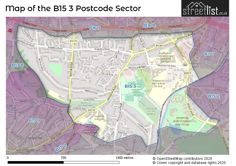
Map of the B15 3 Postcode Sector
Explore the B15 3 postcode sector by using our free interactive map.
| B | 1 | 5 | - | 3 | X | X |
| B | 1 | 5 | Space | 3 | Letter | Letter |
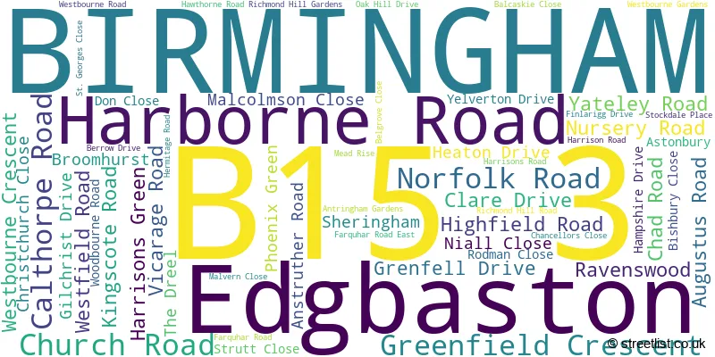
Official List of Streets
BIRMINGHAM (44 Streets)
Edgbaston (15 Streets)
Unofficial Streets or Alternative Spellings
Edgbaston
ARTHUR ROAD EMBASSY DRIVE METCHLEY LANEBIRMINGHAM
EDGBASTON PARK ROAD AUGUSTUS COURT BCS MAIN PATH BROOK ROAD CHAD SQUARE CHADBROOK CREST CHAPEL PATH CROFTERS COURT EDGBASTON VILLAGE WALK HARTLEY PLACE HINDON SQUARE NICHOLSON DRIVE PETERSHAM PLACE THE VALE WILSFORD GREEN WOODBOURNEHarborne
HIGH STREETSchools and Places of Education Within the B15 3 Postcode Sector
Chad Vale Primary School
Community school
Nursery Road, Birmingham, West Midlands, B15 3JU
Head: Mr Paul Sansom
Ofsted Rating: Good
Inspection: 2023-10-04 (232 days ago)
Website: Visit Chad Vale Primary School Website
Phone: 01214647329
Number of Pupils: 418
Harborne Academy
Academy sponsor led
Harborne Road, Birmingham, West Midlands, B15 3JL
Head: Mrs Sarah Ross
Ofsted Rating: Good
Inspection: 2022-11-16 (554 days ago)
Website: Visit Harborne Academy Website
Phone: 01214642737
Number of Pupils: 606
House Prices in the B15 3 Postcode Sector
| Type of Property | 2018 Average | 2018 Sales | 2017 Average | 2017 Sales | 2016 Average | 2016 Sales | 2015 Average | 2015 Sales |
|---|---|---|---|---|---|---|---|---|
| Detached | £989,996 | 26 | £769,013 | 26 | £611,229 | 37 | £690,331 | 26 |
| Semi-Detached | £493,500 | 5 | £362,936 | 8 | £620,500 | 6 | £668,400 | 6 |
| Terraced | £342,214 | 7 | £450,749 | 12 | £375,161 | 9 | £304,167 | 6 |
| Flats | £228,245 | 158 | £268,239 | 98 | £220,119 | 72 | £158,874 | 45 |
Important Postcodes B15 3 in the Postcode Sector
B15 3AA is the postcode for 12 Harborne Road
B15 3JL is the postcode for Harborne Academy, Harborne Road
B15 3JU is the postcode for Chad Vale Primary, Nursery Road, Edgbaston, Chad Vale Primary School, Nursery Road, and BIRMINGHAM CITY COUNCIL, Chad Vale Primary School, Nursery Road
B15 3SS is the postcode for ELGAR COURT, Flat 1 Elgar Court, Church Road
B15 3SX is the postcode for University of Birmingham, Shackleton Hall, Church Road
B15 3SZ is the postcode for AITKEN WING, University of Birmingham, Chamberlain Hall, Church Road
B15 3TF is the postcode for MAPLE BANK FLATS, The Estate Office, Maple Bank
B15 3TN is the postcode for Seacole Building, Westbourne Road, Ravensbury House, Westbourne Road, Oakmount House, Westbourne Road, Bevan House, Westbourne Road, Calthorpe House, Westbourne Road, Westmount House, Westbourne Road, and Seacole Building, Westbourne Road, Edgbaston
B15 3TS is the postcode for Edgbaston High School for Girls, Westbourne Road
| The B15 3 Sector is within these Local Authorities |
|
|---|---|
| The B15 3 Sector is within these Counties |
|
| The B15 3 Sector is within these Water Company Areas |
|
Tourist Attractions within the B15 3 Postcode Area
We found 1 visitor attractions within the B1 postcode area
| Birmingham Botanical Gardens and Glasshouses |
|---|
| Gardens |
| Garden |
| View Birmingham Botanical Gardens and Glasshouses on Google Maps |