The B16 0 postcode sector is within the county of West Midlands.
Did you know? According to the 2021 Census, the B16 0 postcode sector is home to a bustling 10,321 residents!
Given that each sector allows for 400 unique postcode combinations. Letters C, I, K, M, O and V are not allowed in the last two letters of a postcode. With 152 postcodes already in use, this leaves 248 units available.
The largest settlements in the B16 0 postal code are BIRMINGHAM and Edgbaston.
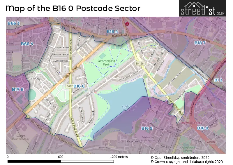
The B16 0 Postcode shares a border with B16 9 (BIRMINGHAM, Edgbaston), B17 8 (BIRMINGHAM, Edgbaston, Harborne), B66 4 (SMETHWICK), B16 8 (BIRMINGHAM, Edgbaston, Ladywood), B18 4 (BIRMINGHAM, Hockley, Winson Green), B18 7 (BIRMINGHAM, Hockley) and B66 2 (SMETHWICK, Middlemore Industrial Estate).
The sector is within the post town of BIRMINGHAM.
B16 0 is a postcode sector within the B1 postcode district which is within the B Birmingham postcode area.
The Royal Mail delivery office for the B16 0 postal sector is the unknown.
The area of the B16 0 postcode sector is 0.63 square miles which is 1.62 square kilometres or 400.50 square acres.
Waterways within the B16 0 postcode sector include the Birmingham Canal Navigations.

Map of the B16 0 Postcode Sector
Explore the B16 0 postcode sector by using our free interactive map.
| B | 1 | 6 | - | 0 | X | X |
| B | 1 | 6 | Space | 0 | Letter | Letter |
Official List of Streets
BIRMINGHAM (65 Streets)
Unofficial Streets or Alternative Spellings
BIRMINGHAM
CLARK STREET COPE STREET DUDLEY ROAD LADYWOOD MIDDLEWAY OSLER STREET PORTLAND ROAD SPRINGFIELD STREET STOUR STREET BELLEVUE AVENUE BUTLERS WALK CITY TRADING ESTATE COPLOW COTTAGES COPLOW TERRACE HARBORNE WALKWAY MAGREAL INDUSTRIAL ESTATE ROTTON PARK JUNCTION WALKOVER BRIDGE NUMBER 3 SUMMERFIELD ROAD THE ELMS THE HOLLIES THE LAURELS THE LIMES VICTORIA BUILDINGS WEST GATE WICKET ROADSMETHWICK
BARRETT STREET CAPE HILL GROVE LANESchools and Places of Education Within the B16 0 Postcode Sector
Barford Primary School
Community school
Barford Road, Birmingham, West Midlands, B16 0EF
Head: Miss Joanne Davies
Ofsted Rating: Good
Inspection: 2023-11-08 (210 days ago)
Website: Visit Barford Primary School Website
Phone: 01214643765
Number of Pupils: 421
City Road Primary School
Academy sponsor led
City Road, Birmingham, , B16 0HL
Head: Mr Shaukat Islam
Ofsted Rating: Good
Inspection: 2023-01-25 (497 days ago)
Website: Visit City Road Primary School Website
Phone: 01214643348
Number of Pupils: 440
House Prices in the B16 0 Postcode Sector
| Type of Property | 2018 Average | 2018 Sales | 2017 Average | 2017 Sales | 2016 Average | 2016 Sales | 2015 Average | 2015 Sales |
|---|---|---|---|---|---|---|---|---|
| Detached | £314,519 | 21 | £307,457 | 39 | £321,295 | 12 | £275,207 | 12 |
| Semi-Detached | £265,839 | 35 | £249,357 | 43 | £244,648 | 27 | £245,785 | 28 |
| Terraced | £174,755 | 37 | £159,824 | 39 | £130,100 | 40 | £113,459 | 45 |
| Flats | £117,494 | 8 | £128,624 | 15 | £95,611 | 9 | £78,863 | 4 |
Important Postcodes B16 0 in the Postcode Sector
B16 0EF is the postcode for Barford Junior & Infant School, Barford Road
B16 0HL is the postcode for City Road Junior And Infant School, City Road, Soho, and City Road Junior & Infant School, City Road
B16 0RA is the postcode for Fire Station, Icknield Port Road, and West Midlands Fire Service, Ladywood Fire Station, Icknield Port Road
| The B16 0 Sector is within these Local Authorities |
|
|---|---|
| The B16 0 Sector is within these Counties |
|
| The B16 0 Sector is within these Water Company Areas |
|