The BD12 9 postcode sector is within the county of West Yorkshire.
Did you know? According to the 2021 Census, the BD12 9 postcode sector is home to a bustling 4,811 residents!
Given that each sector allows for 400 unique postcode combinations. Letters C, I, K, M, O and V are not allowed in the last two letters of a postcode. With 148 postcodes already in use, this leaves 252 units available.
The BD12 9 postal code covers the settlement of Wyke.
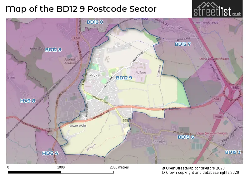
The BD12 9 Postcode shares a border with BD12 7 (Oakenshaw, BRADFORD), BD12 0 (Low Moor, BRADFORD), BD12 8 (Wyke), BD19 6 (Scholes, CLECKHEATON, Chain Bar) and HD6 4 (BRIGHOUSE, Bailiff Bridge, Clifton).
The sector is within the post town of BRADFORD.
BD12 9 is a postcode sector within the BD12 postcode district which is within the BD Bradford postcode area.
The Royal Mail delivery office for the BD12 9 postal sector is the Bradford South Delivery Office.
The area of the BD12 9 postcode sector is 1.28 square miles which is 3.31 square kilometres or 818.82 square acres.

Map of the BD12 9 Postcode Sector
Explore the BD12 9 postcode sector by using our free interactive map.
| B | D | 1 | 2 | - | 9 | X | X |
| B | D | 1 | 2 | Space | 9 | Letter | Letter |
Official List of Streets
Wyke (89 Streets)
BRADFORD (2 Streets)
Lower Wyke (1 Streets)
Schools and Places of Education Within the BD12 9 Postcode Sector
Worthinghead Primary School
Community school
Wyke Lane, Bradford, West Yorkshire, BD12 9EL
Head: Mrs Lillian Sharp
Ofsted Rating: Good
Inspection: 2022-05-18 (739 days ago)
Website: Visit Worthinghead Primary School Website
Phone: 01274414904
Number of Pupils: 211
House Prices in the BD12 9 Postcode Sector
| Type of Property | 2018 Average | 2018 Sales | 2017 Average | 2017 Sales | 2016 Average | 2016 Sales | 2015 Average | 2015 Sales |
|---|---|---|---|---|---|---|---|---|
| Detached | £251,914 | 18 | £194,556 | 9 | £206,750 | 10 | £178,964 | 14 |
| Semi-Detached | £154,981 | 39 | £158,979 | 51 | £138,736 | 39 | £142,278 | 34 |
| Terraced | £96,386 | 29 | £105,320 | 41 | £88,573 | 39 | £91,926 | 33 |
| Flats | £0 | 0 | £66,000 | 1 | £47,000 | 2 | £0 | 0 |
Important Postcodes BD12 9 in the Postcode Sector
BD12 9EL is the postcode for Worthinghead Primary School, Wyke Lane
BD12 9NG is the postcode for Cowgill Surgery, Thornaby Drive, Sunnybank Medical Centre, Town Gate, and Affinity Care, Sunnybank Medical Centre, Town Gate
BD12 9NT is the postcode for Top Odd, 40-42 Town Gate
BD12 9PX is the postcode for Wyke Manor School, Mayfield Avenue, and Appleton Academy, Mayfield Avenue
| The BD12 9 Sector is within these Local Authorities |
|
|---|---|
| The BD12 9 Sector is within these Counties |
|
| The BD12 9 Sector is within these Water Company Areas |
|