The BH13 7 postcode sector is within the county of Dorset.
Did you know? According to the 2021 Census, the BH13 7 postcode sector is home to a bustling 3,760 residents!
Given that each sector allows for 400 unique postcode combinations. Letters C, I, K, M, O and V are not allowed in the last two letters of a postcode. With 164 postcodes already in use, this leaves 236 units available.
The largest settlements in the BH13 7 postal code are POOLE and Branksome Park.
The BH13 7 Postcode shares a border with BH14 8 (POOLE, Parkstone), BH14 9 (POOLE, Parkstone), BH20 5 (Corfe Castle, WAREHAM, West Lulworth) and BH13 6 (POOLE, Branksome Park).
The sector is within the post town of POOLE.
BH13 7 is a postcode sector within the BH13 postcode district which is within the BH Bournemouth postcode area.
The Royal Mail delivery office for the BH13 7 postal sector is the Westbourne Delivery Office.
The area of the BH13 7 postcode sector is 1.97 square miles which is 5.10 square kilometres or 1,260.81 square acres.

Map of the BH13 7 Postcode Sector
Explore the BH13 7 postcode sector by using our free interactive map.
| B | H | 1 | 3 | - | 7 | X | X |
| B | H | 1 | 3 | Space | 7 | Letter | Letter |
Official List of Streets
POOLE (51 Streets)
Branksome Park (1 Streets)
Canford Cliffs (1 Streets)
Unofficial Streets or Alternative Spellings
POOLE
BOULNOIS AVENUE CANFORD CLIFFS AVENUE CHESTER ROAD EATON ROAD LEICESTER ROAD LILLIPUT ROAD LINKS ROAD PINECLIFF ROAD SPUR HILL AVENUE TOWER ROAD WEST BRANKSOME CHINE PROMENADE CAMBRIDGE WOODS WALK CANFORD CLIFFS PROMENADE DEER PARK ROAD ESPLANADE FLAG FARM FLAGHEAD CHINE ROAD GIN ALLEY HARBOUR CLOSE MIDDLE STREET MIDWAY PATH SANDBACKS PROMENADE SHORE ROAD PROMENADE THE CIRCLE THE DRIVE THE GLEN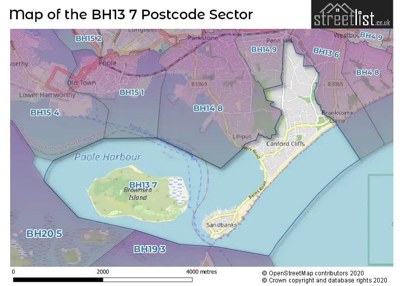
House Prices in the BH13 7 Postcode Sector
| Type of Property | 2018 Average | 2018 Sales | 2017 Average | 2017 Sales | 2016 Average | 2016 Sales | 2015 Average | 2015 Sales |
|---|---|---|---|---|---|---|---|---|
| Detached | £1,753,912 | 54 | £1,323,972 | 54 | £1,651,814 | 63 | £1,466,033 | 54 |
| Semi-Detached | £633,333 | 3 | £928,750 | 4 | £849,950 | 1 | £0 | 0 |
| Terraced | £1,426,171 | 5 | £1,160,000 | 2 | £664,000 | 5 | £1,816,667 | 3 |
| Flats | £654,488 | 71 | £645,022 | 129 | £549,542 | 94 | £560,863 | 86 |
Important Postcodes BH13 7 in the Postcode Sector
BH13 7LN is the postcode for NEW BLOCK, St. Anns Hospital, 69 Haven Road, OLD BLOCK, St. Anns Hospital, 69 Haven Road, and Dorset Healthcare NHS Foundation Trust, St Anns Hospital
| The BH13 7 Sector is within these Local Authorities |
|
|---|---|
| The BH13 7 Sector is within these Counties |
|
| The BH13 7 Sector is within these Water Company Areas |
|
Tourist Attractions within the BH13 7 Postcode Area
We found 1 visitor attractions within the BH13 postcode area
| Brownsea Island |
|---|
| Wildlife |
| Nature Reserve / Wetlands / Wildlife Trips |
| View Brownsea Island on Google Maps |