The BS20 0 postcode sector stands on the Bristol and Somerset border.
Did you know? According to the 2021 Census, the BS20 0 postcode sector is home to a bustling 4,998 residents!
Given that each sector allows for 400 unique postcode combinations. Letters C, I, K, M, O and V are not allowed in the last two letters of a postcode. With 177 postcodes already in use, this leaves 223 units available.
The largest settlements in the BS20 0 postal code are Pill and Easton-in-Gordano.
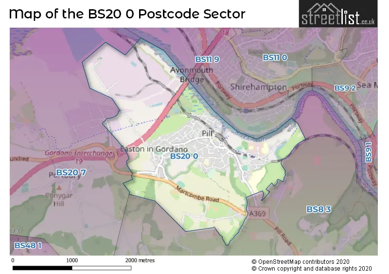
The BS20 0 Postcode shares a border with BS8 3 (BRISTOL, Clifton, Failand), BS11 9 (BRISTOL, Avonmouth, Shirehampton) and BS20 7 (Portishead, Portbury, Clapton In Gordano).
The sector is within the post town of BRISTOL.
BS20 0 is a postcode sector within the BS2 postcode district which is within the BS Bristol postcode area.
The Royal Mail delivery office for the BS20 0 postal sector is the Bristol East Central Delivery Office.
The area of the BS20 0 postcode sector is 2.29 square miles which is 5.92 square kilometres or 1,463.01 square acres.
The BS20 0 postcode sector is crossed by the M5 motorway.

Map of the BS20 0 Postcode Sector
Explore the BS20 0 postcode sector by using our free interactive map.
| B | S | 2 | 0 | - | 0 | X | X |
| B | S | 2 | 0 | Space | 0 | Letter | Letter |
Official List of Streets
Pill (68 Streets)
Easton-in-Gordano (34 Streets)
Unofficial Streets or Alternative Spellings
Pill
BRIAR COURT KESWICK GARDENS LOWER MYRTLE HILLAbbots Leigh
PILL ROAD BOW GARDENS BRINSMEAD CRESCENT BRUNSMEAD CRESCENT CHAPEL PILL FARM CHURCHPATH ROAD GARONOR WAY GORDANO ROUND GORDANO ROUND LINK GORDANO SERVICES GORDANO WAY HABERFIELD HILL MAGGIES COTTAGES NORMANS WAY NORTH GROVE-RUDLEIGH ROAD LINK PARK WALK PERRETT WAY POND HEAD POND HEAD COURT SAINT GEORGES CLOSE SAINT GEORGES HILL ST GEORGES ROAD THE ORCHARD UNDERBANKS WELCOME BREAK GORDANO SERVICESPortbury
BRADLEY ROAD ROYAL PORTBURY DOCK ROADWeather Forecast for BS20 0
Press Button to Show Forecast for Shirehampton
| Time Period | Icon | Description | Temperature | Rain Probability | Wind |
|---|---|---|---|---|---|
| 12:00 to 15:00 | Partly cloudy (day) | 16.0°C (feels like 15.0°C) | 1.00% | WNW 7 mph | |
| 15:00 to 18:00 | Cloudy | 18.0°C (feels like 17.0°C) | 4.00% | W 7 mph | |
| 18:00 to 21:00 | Cloudy | 16.0°C (feels like 16.0°C) | 4.00% | SW 7 mph | |
| 21:00 to 00:00 | Cloudy | 13.0°C (feels like 13.0°C) | 4.00% | SW 7 mph |
Press Button to Show Forecast for Shirehampton
| Time Period | Icon | Description | Temperature | Rain Probability | Wind |
|---|---|---|---|---|---|
| 00:00 to 03:00 | Cloudy | 13.0°C (feels like 12.0°C) | 4.00% | SW 4 mph | |
| 03:00 to 06:00 | Clear night | 12.0°C (feels like 12.0°C) | 1.00% | SW 2 mph | |
| 06:00 to 09:00 | Mist | 12.0°C (feels like 12.0°C) | 11.00% | SW 2 mph | |
| 09:00 to 12:00 | Mist | 15.0°C (feels like 15.0°C) | 11.00% | W 2 mph | |
| 12:00 to 15:00 | Cloudy | 17.0°C (feels like 16.0°C) | 4.00% | WNW 7 mph | |
| 15:00 to 18:00 | Partly cloudy (day) | 19.0°C (feels like 18.0°C) | 1.00% | WNW 4 mph | |
| 18:00 to 21:00 | Cloudy | 20.0°C (feels like 19.0°C) | 3.00% | W 2 mph | |
| 21:00 to 00:00 | Cloudy | 16.0°C (feels like 16.0°C) | 3.00% | SW 4 mph |
Press Button to Show Forecast for Shirehampton
| Time Period | Icon | Description | Temperature | Rain Probability | Wind |
|---|---|---|---|---|---|
| 00:00 to 03:00 | Cloudy | 14.0°C (feels like 14.0°C) | 4.00% | SSE 4 mph | |
| 03:00 to 06:00 | Cloudy | 12.0°C (feels like 12.0°C) | 4.00% | S 2 mph | |
| 06:00 to 09:00 | Cloudy | 12.0°C (feels like 12.0°C) | 4.00% | E 2 mph | |
| 09:00 to 12:00 | Cloudy | 16.0°C (feels like 17.0°C) | 4.00% | ENE 2 mph | |
| 12:00 to 15:00 | Cloudy | 19.0°C (feels like 19.0°C) | 3.00% | S 2 mph | |
| 15:00 to 18:00 | Partly cloudy (day) | 20.0°C (feels like 19.0°C) | 1.00% | SW 4 mph | |
| 18:00 to 21:00 | Cloudy | 19.0°C (feels like 18.0°C) | 3.00% | WSW 4 mph | |
| 21:00 to 00:00 | Clear night | 15.0°C (feels like 15.0°C) | 0.00% | SSW 4 mph |
Press Button to Show Forecast for Shirehampton
| Time Period | Icon | Description | Temperature | Rain Probability | Wind |
|---|---|---|---|---|---|
| 00:00 to 03:00 | Clear night | 14.0°C (feels like 14.0°C) | 0.00% | SSE 2 mph | |
| 03:00 to 06:00 | Clear night | 12.0°C (feels like 11.0°C) | 0.00% | ESE 4 mph | |
| 06:00 to 09:00 | Sunny day | 12.0°C (feels like 12.0°C) | 0.00% | E 4 mph | |
| 09:00 to 12:00 | Sunny day | 17.0°C (feels like 16.0°C) | 0.00% | ESE 4 mph | |
| 12:00 to 15:00 | Partly cloudy (day) | 19.0°C (feels like 18.0°C) | 0.00% | SSE 7 mph | |
| 15:00 to 18:00 | Partly cloudy (day) | 20.0°C (feels like 19.0°C) | 1.00% | SSE 7 mph | |
| 18:00 to 21:00 | Partly cloudy (day) | 19.0°C (feels like 18.0°C) | 1.00% | SSE 7 mph | |
| 21:00 to 00:00 | Clear night | 16.0°C (feels like 15.0°C) | 0.00% | SE 7 mph |
Press Button to Show Forecast for Shirehampton
| Time Period | Icon | Description | Temperature | Rain Probability | Wind |
|---|---|---|---|---|---|
| 00:00 to 03:00 | Clear night | 14.0°C (feels like 13.0°C) | 0.00% | ESE 7 mph | |
| 03:00 to 06:00 | Cloudy | 13.0°C (feels like 12.0°C) | 4.00% | E 7 mph | |
| 06:00 to 09:00 | Partly cloudy (day) | 13.0°C (feels like 13.0°C) | 2.00% | E 4 mph | |
| 09:00 to 12:00 | Partly cloudy (day) | 17.0°C (feels like 16.0°C) | 2.00% | SE 7 mph | |
| 12:00 to 15:00 | Cloudy | 19.0°C (feels like 18.0°C) | 7.00% | SSE 9 mph | |
| 15:00 to 18:00 | Cloudy | 20.0°C (feels like 19.0°C) | 10.00% | S 9 mph | |
| 18:00 to 21:00 | Cloudy | 18.0°C (feels like 16.0°C) | 12.00% | S 9 mph | |
| 21:00 to 00:00 | Cloudy | 15.0°C (feels like 14.0°C) | 11.00% | SSE 9 mph |
Schools and Places of Education Within the BS20 0 Postcode Sector
Crockerne Church of England Primary School
Academy converter
Westward Drive, Bristol, , BS20 0JP
Head: Headteacher Emma Bray
Ofsted Rating: Good
Inspection: 2023-01-25 (469 days ago)
Website: Visit Crockerne Church of England Primary School Website
Phone: 01275372659
Number of Pupils: 325
St Katherine's School
Academy converter
Pill Road, Bristol, Somerset, BS20 0HU
Head: Mr Justin Humphreys
Ofsted Rating: Good
Inspection: 2021-12-09 (881 days ago)
Website: Visit St Katherine's School Website
Phone: 01275373737
Number of Pupils: 1000
House Prices in the BS20 0 Postcode Sector
| Type of Property | 2018 Average | 2018 Sales | 2017 Average | 2017 Sales | 2016 Average | 2016 Sales | 2015 Average | 2015 Sales |
|---|---|---|---|---|---|---|---|---|
| Detached | £444,720 | 25 | £415,370 | 23 | £354,804 | 28 | £340,563 | 24 |
| Semi-Detached | £272,150 | 25 | £273,554 | 20 | £240,571 | 26 | £237,517 | 26 |
| Terraced | £265,763 | 20 | £246,324 | 21 | £242,573 | 13 | £224,639 | 23 |
| Flats | £177,940 | 5 | £184,390 | 5 | £180,694 | 18 | £136,832 | 6 |
Important Postcodes BS20 0 in the Postcode Sector
BS20 0AB is the postcode for North Somerset Primary Care Trust, Pill Health Clinic, 3 Station Road
BS20 0DL is the postcode for Heywood Surgery, 1 Lodway Gardens
BS20 0HE is the postcode for Orchard View, Ham Green, Perrett Way
BS20 0HH is the postcode for North Bristol NHS Trust, Ham Green Orchard View
BS20 0HU is the postcode for ENGLISH BLOCK, St. Katherines School, Ham Green, Pill Road, SPORTS HALL, St. Katherines School, Ham Green, Pill Road, ADMIN/LIBRARY BLOCK, St. Katherines School, Ham Green, Pill Road, HUMANITIES BLOCK, St. Katherines School, Ham Green, Pill Road, St. Katherines School, Ham Green, Pill Road, HOSPITALITY BLOCK, St. Katherines School, Ham Green, Pill Road, and MAIN SCHOOL BUILDING, St. Katherines School, Ham Green, Pill Road
BS20 0JP is the postcode for Crockerne Primary School, Westward Drive, Pill, and Crockerne Primary School, Westward Drive
| The BS20 0 Sector is within these Local Authorities |
|
|---|---|
| The BS20 0 Sector is within these Counties |
|
| The BS20 0 Sector is within these Water Company Areas |
|