This section of the site is all about the BS Postcode area, also known as the Bristol Postal Area. Explore links to the next level to learn more about specific postcode districts such as BS1.
Map of the BS Postcode for Bristol
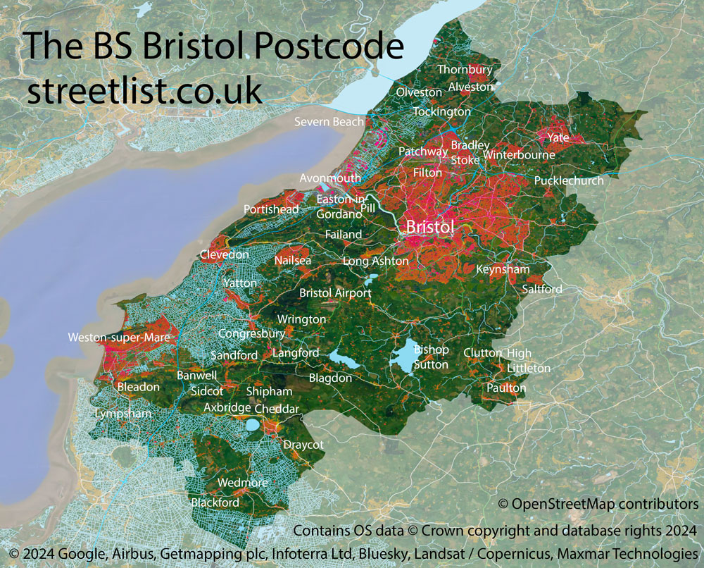
The BS postcode area represents a group of postal districts in the Bristol area of the United Kingdom. The area code BS stands for the letters b and s in BriStol. BS has a population of 940,241 and covers an area of 1,160,476 hectares. Fun fact: 1.45% of the population of Great Britain lives in this area.
The postcode area falls within the following counties: Bristol (43.18%), Somerset (32.68%), Gloucestershire (24.14%).
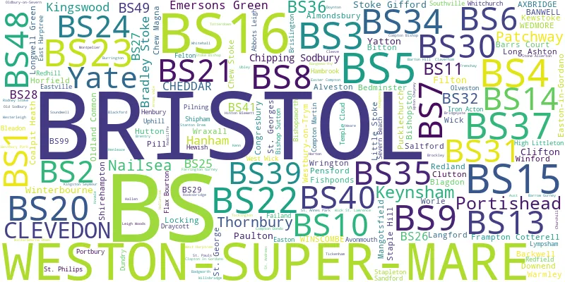
Post Towns and Postcode Districts for the BS Postcode
-
BS1 BristolBS2 BristolBS3 BristolBS4 BristolBS5 BristolBS6 BristolBS7 Bristol (92%), Gloucestershire (7%)BS8 Bristol (89%), Somerset (10%)BS9 BristolBS10 Bristol (90%), Gloucestershire (9%)BS11 BristolBS13 BristolBS14 Bristol (91%), Somerset (8%)BS15 Bristol (17%), Gloucestershire (82%)BS16 Bristol (45%), Gloucestershire (54%)BS20 Bristol (4%), Somerset (95%)BS30 GloucestershireBS31 SomersetBS32 GloucestershireBS34 GloucestershireBS35 GloucestershireBS36 GloucestershireBS37 GloucestershireBS39 SomersetBS40 SomersetBS41 Bristol (1%), Somerset (98%)BS48 SomersetBS49 SomersetBS98 BS99
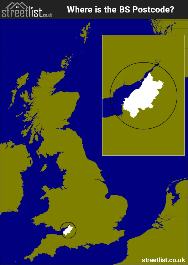
Where is the BS Postcode Area?
The BS Bristol Postcode is in the South West of England. The postal area borders the following neighbouring postal areas: TA - Taunton, SN - Swindon, GL - Gloucester, NP - Newport and BA - Bath, It also borders The Bristol Channel,
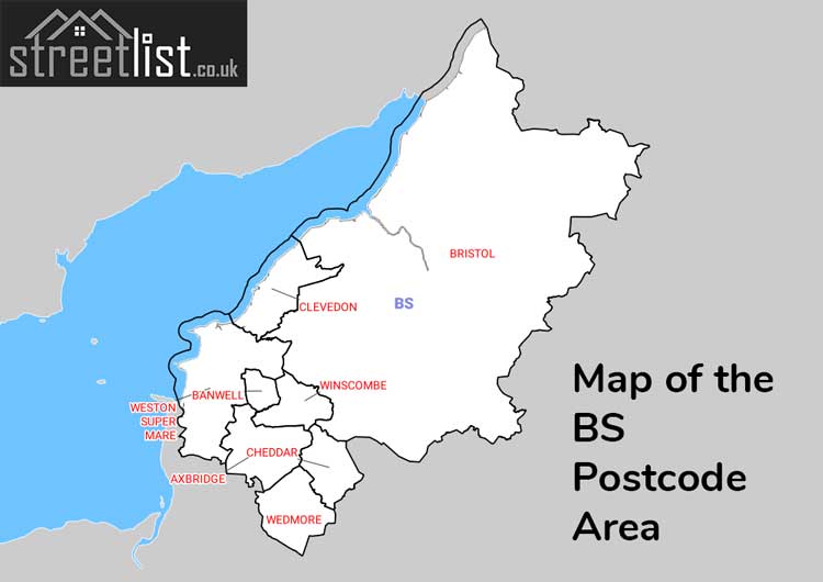
Map of the BS Bristol Postcode Area
Explore the BS Bristol postcode area by using our interactive map.
Postcode Districts within the BS Bristol Postcode Area
There are 37 postcode districts within the Bristol postcode area

A map showing the boundary of in relation to other areas
There are 12 towns within the Bristol postcode area.
| Unit | Area² |
|---|---|
| Hectares | 1,160,476² |
| Miles | 4,481² |
| Feet | 124,912,476,164² |
| Kilometres | 11,605² |
Postal Delivery Offices serving the BS Bristol Postcode Area
- Avonmouth Delivery Office
- Axbridge Scale Payment Delivery Office
- Blag Delivery Office N Scale Payment Delivery Office
- Bristol City Delivery Office
- Bristol East Central Delivery Office
- Bristol East Delivery Office
- Bristol North Delivery Office
- Bristol South Delivery Office
- Bristol South East Delivery Office
- Cheddar Delivery Office
- Chew Stoke Scale Payment Delivery Office
- Clevedon Delivery Office
- Clifton (bs) Delivery Office
- Clutton Scale Payment Delivery Office
- Compton Martin Scale Payment Delivery Office
- Easter Compton Scale Payment Delivery Office
- Felton Scale Payment Delivery Office
- Fishponds Delivery Office
- Hallatrow Scale Payment Delivery Office
- Keynsham Delivery Office
- Kingswood Delivery Office
- Long Ashton Wayside Office
- Mangotsfield Scale Payment Delivery Office
- Nailsea Delivery Office
- Patchway Delivery Office
- Paulton Scale Payment Delivery Office
- Pensford Scale Payment Delivery Office
- Pill Scale Payment Delivery Office
- Pilning Scale Payment Delivery Office
- Portishead Delivery Office
- Thornbury Delivery Office
- Wedmore Scale Payment Delivery Office
- Westbury On Trym Delivery Office
- Weston Super Mare Delivery Office
- Winscombe Delivery Office
- Winterbourne Delivery Office
- Wrington Scale Payment Delivery Office
- Yate Delivery Office
- Yatton Scale Payment Delivery Office
Councils with Postcodes in BS
Towns and Villages within the BS Bristol Postcode Area
- Abbots Leigh - village
- Almondsbury - village
- Alveston - village
- Aust - village
- Avonmouth - Settlement
- Axbridge - town
- Backwell - village
- Badgworth - village
- Banwell - village
- Barrow Common - village
- Barrow Gurney - village
- Biddisham - village
- Bishop Sutton - village
- Bitton - village
- Blackford - village
- Blagdon - village
- Bleadon - village
- Bradley Stoke - town
- Bristol - city
- Brockley - village
- Broomhill - village
- Burchells Green - village
- Burrington - village
- Butcombe - village
- Cambridge Batch - village
- Chapel Allerton - village
- Cheddar - village
- Chelwood - village
- Chester Park - village
- Chew Magna - village
- Chew Stoke - village
- Chipping Sodbury - town
- Churchill - village
- Clapton in Gordano - village
- Claverham - village
- Cleeve - village
- Clevedon - town
- Clutton - village
- Clutton Hill - village
- Coalpit Heath - village
- Cocklake - village
- Compton Bishop - village
- Compton Dando - village
- Congresbury - village
- Cribbs Causeway - village
- Crickham - village
- Crofts End - village
- Cross - village
- Downside - village
- Doynton - village
- Draycott - village
- Dundry - village
- East Harptree - village
- Easter Compton - village
- Eastertown - village
- Easton-in-Gordano - village
- Elberton - village
- Elborough - village
- Engine Common - village
- Failand - village
- Farleigh - village
- Farrington Gurney - village
- Felton - village
- Filton - town
- Fishponds - Settlement
- Flax Bourton - village
- Frampton Cotterell - village
- Frenchay - village
- Hallatrow - village
- Hallen - village
- Hambrook - village
- Heath House - village
- Hewish - village
- High Littleton - village
- Hillfields - village
- Hinton Blewett - village
- Horton - village
- Hutton - village
- Iron Acton - village
- Kendleshire / Kendleshire Crossroads - village
- Kenn - village
- Kewstoke - village
- Keynsham - town
- Kingston Seymour - village
- Kingswood - Urban Area
- Kington - village
- Leigh Woods - village
- Littleton-upon-Severn - village
- Locking - village
- Long Ashton - village
- Lower Langford - village
- Lower Morton - village
- Lower Weare - village
- Loxton - village
- Lympsham - village
- Mangotsfield - Settlement
- Midsomer Norton - town
- Mudgley - village
- Nailsea - town
- New Passage - village
- Nibley - village
- North End - village
- Old Down - village
- Old Sodbury - village
- Oldbury Naite - village
- Oldbury-on-Severn - village
- Oldland - village
- Olveston - village
- Patchway - Settlement
- Paulton - village
- Pensford - village
- Pill - village
- Pilning - village
- Portbury - Settlement
- Portishead - town
- Potters Hill - village
- Pucklechurch - village
- Queen Charlton - village
- Rangeworthy - village
- Redhill - village
- Rickford - village
- Rodney Stoke - village
- Rooks Bridge - village
- Rudgeway - village
- Saltford - village
- Sandford - village
- Severn Beach - village
- Sheepway - village
- Shipham - village
- Shortwood - village
- Siston - village
- Stanton Drew - village
- Stapleton - village
- Star - village
- Stock - village
- Stoke Gifford - Settlement
- Stone Allerton - village
- Stone-edge Batch - village
- Temple Cloud - village
- Theale - village
- Thornbury - town
- Tickenham - village
- Tockington - village
- Tormarton - village
- Two Mile Hill - village
- Ubley - village
- Upper Langford - otherSettlement
- Upper Stanton Drew - village
- Upton Cheyney - village
- Walton Bay - village
- Walton in Gordano - village
- Wapley - village
- Warmley - village
- Weare - village
- Wedmore - village
- West Harptree - village
- West Hill - village
- West Wick - village
- Westerleigh - village
- Weston in Gordano - village
- Weston-Super-Mare - town
- Whitchurch - village
- Whiteshill - village
- Whiteway - village
- Wick - village
- Wick St Lawrence - village
- Winford - village
- Winscombe - village
- Winterbourne - village
- Woodhouse Down - village
- Woollard - village
- Wraxall - village
- Wrington - village
- Yate - town
- Yatton - village