This section of the site is all about the SN Postcode area, also known as the Swindon Postal Area. Explore links to the next level to learn more about specific postcode districts such as SN1.
The SN postcode area represents a group of postal districts in the Swindon area of the United Kingdom. The area code SN stands for the letters s and n in SwiNdon. SN has a population of 459,049 and covers an area of 2,152,303 hectares. Fun fact: 0.71% of the population of Great Britain lives in this area.
The postcode area falls within the following counties: Wiltshire (94.14%), Oxfordshire (5.15%), Gloucestershire (0.71%), Berkshire (0.01%).
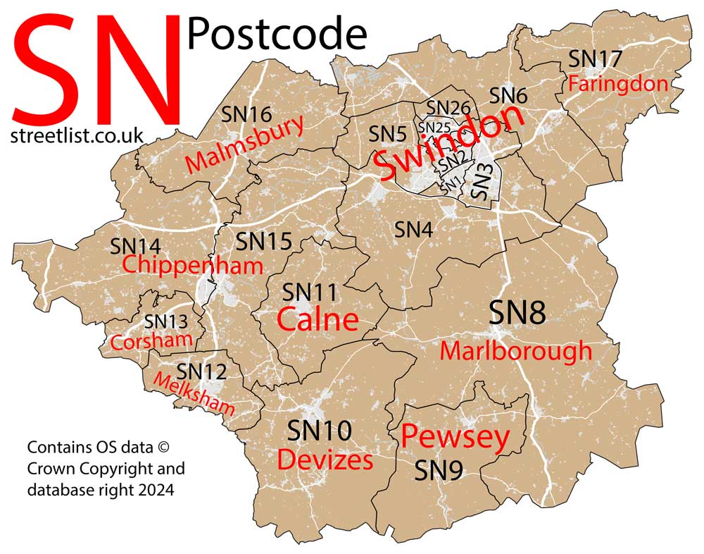
Post Towns and Postcode Districts for the SN Postcode
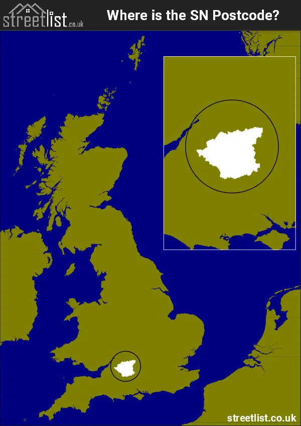
Where is the SN Postcode Area?
The SN Swindon Postcode is in the South West England. The postal area borders the following neighbouring postal areas: SP - Salisbury, GL - Gloucester, OX - Oxford, BA - Bath, RG - Reading and BS - Bristol, and is located inland.
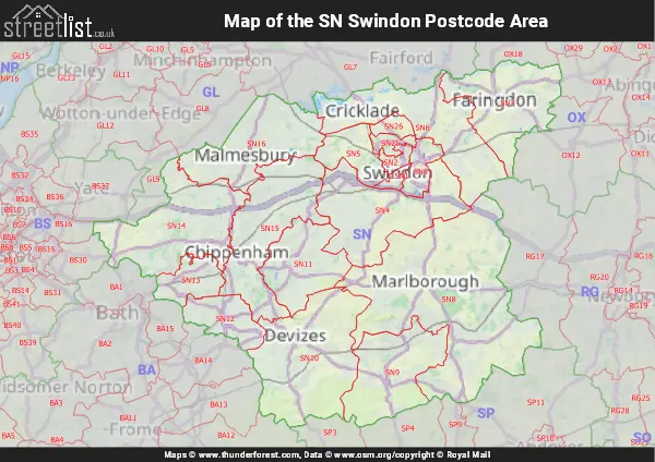
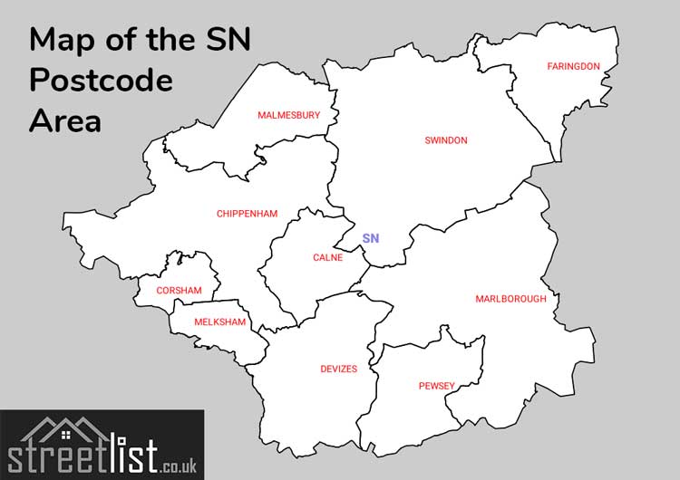
Map of the SN Swindon Postcode Area
Explore the SN Swindon postcode area by using our interactive map.
Postcode Districts within the SN Swindon Postcode Area
There are 18 postcode districts within the Swindon postcode area
A map showing the boundary of in relation to other areas
There are 12 towns within the Swindon postcode area.
| Unit | Area² |
|---|---|
| Hectares | 2,152,303² |
| Miles | 8,310² |
| Feet | 231,671,742,617² |
| Kilometres | 21,523² |
Postal Delivery Offices serving the SN Swindon Postcode Area
- Burbage Scale Payment Delivery Office
- Calne Delivery Office
- Chippenham Delivery Office
- Corsham Delivery Office
- Cricklade Scale Payment Delivery Office
- Delivery Office Rcan Postal Delivery Office
- Devizes Delivery Office
- Faringdon Delivery Office
- Hawksworth Delivery Office
- Highworth Scale Payment Delivery Office
- Malmesbury Delivery Office
- Marlborough Delivery Office
- Melksham Delivery Office
- Pewsey Delivery Office
- West Swindon Delivery Office
- Wootton Bassett Postal Delivery Office
Councils with Postcodes in SN
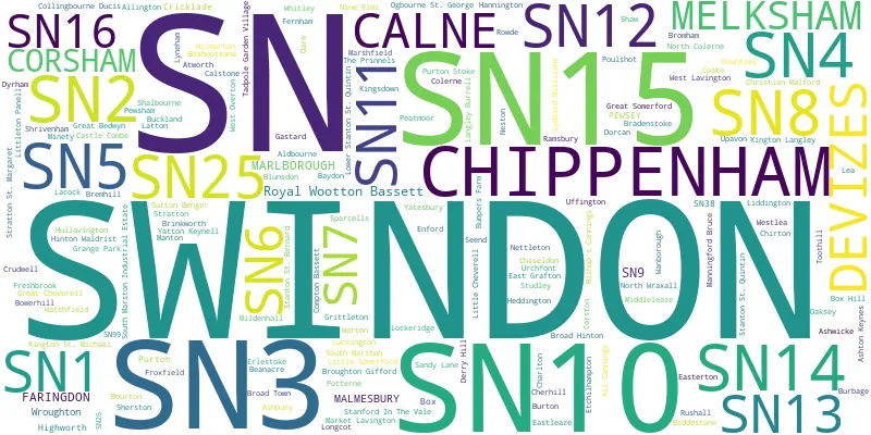
Towns and Villages within the SN Swindon Postcode Area
- Aldbourne - village
- Alderton - village
- All Cannings - village
- Alton Barnes - village
- Ashbury - village
- Ashley - village
- Ashton Keynes - village
- Atworth - village
- Aughton - village
- Avebury - village
- Avebury Trusloe - village
- Axford - village
- Badbury - village
- Baydon - village
- Beanacre - village
- Berryfield - village
- Biddestone - village
- Bishops Cannings - village
- Bishopstone - village
- Blunsdon St Andrew - village
- Bottlesford - village
- Bourton - village
- Bowden Hill - village
- Bowerhill - village
- Box - village
- Box Hill - village
- Bradenstoke - village
- Bremhill - village
- Brinkworth - village
- Broad Blunsdon - village
- Broad Hinton - village
- Broad Town - village
- Bromham - village
- Broughton Gifford - village
- Bulkington - village
- Burbage - village
- Burton - village
- Buscot - village
- Bushton - village
- Cadley - village
- Callow Hill - village
- Calne - town
- Castle Eaton - village
- Charlton - village
- Charlton St Peter - village
- Chelworth - village
- Cherhill - village
- Chippenham - town
- Chirton - village
- Chiseldon - village
- Christian Malford - village
- Clench Common - otherSettlement
- Coate - village
- Cold Ashton - village
- Colerne - village
- Collingbourne Ducis - village
- Collingbourne Kingston - village
- Compton Bassett - village
- Corsham - town
- Corston - village
- Cricklade - town
- Crudwell - village
- Dauntsey - village
- Derry Hill - village
- Devizes - town
- Dyrham - village
- East Grafton - village
- East Kennett - village
- East Tytherton - village
- Easterton - village
- Easton Grey - village
- Easton Royal - village
- Enford - village
- Erlestoke - village
- Etchilhampton - village
- Everleigh - village
- Faringdon - town
- Fernham - village
- Ford - village
- Foxham - village
- Froxfield - village
- Fyfield - village
- Gastard - village
- Goatacre - village
- Goosey - village
- Great Bedwyn - village
- Great Cheverell - village
- Great Coxwell - village
- Great Somerford - village
- Grittleton - village
- Ham - village
- Hankerton - village
- Hannington - village
- Hatford - village
- Heddington - village
- Highworth - town
- Hilcott - village
- Hilmarton - village
- Hinton - village
- Hinton Parva - village
- Hinton Waldrist - village
- Honeystreet - village
- Hook - village
- Horton - village
- Hullavington - village
- Kingsdown - village
- Kington Langley - village
- Kington St Michael - village
- Lacock - village
- Langley Burrell - village
- Latton - village
- Lavington Sands - village
- Lea - village
- Liddington - village
- Little Bedwyn - village
- Little Cheverell - village
- Little Coxwell - village
- Little Somerford - village
- Littlecott - village
- Littleton Panell - village
- Littleworth - village
- Lockeridge - village
- Longcot - village
- Lower Stanton St Quintin - village
- Luckington - village
- Lydiard Millicent - village
- Lyneham - village
- Malmesbury - town
- Manningford Abbots - village
- Manningford Bohune - village
- Manton - village
- Marden - village
- Market Lavington - village
- Marlborough - town
- Marshfield - village
- Marston - village
- Marston Meysey - village
- Melksham - town
- Milbourne - village
- Mildenhall - village
- Milton Lilbourne - village
- Minety - village
- Neston - village
- Nettleton - village
- North Wraxall - village
- Norton - otherSettlement
- Notton - village
- Oaksey - village
- Oare - village
- Ogbourne St Andrew - village
- Ogbourne St George - village
- Patney - village
- Pewsey - village
- Potterne - village
- Poulshot - village
- Purton - village
- Purton Stoke - village
- Ramsbury - village
- Rowde - village
- Royal Wootton Bassett - town
- Rudloe - village
- Rushall - village
- Sandy Lane - village
- Seend - village
- Seend Cleeve - village
- Sells Green - village
- Sevenhampton - village
- Shalbourne - village
- Shaw - village
- Shellingford - village
- Sherston - village
- Sherston Parva / Pinkney - village
- Shrivenham - village
- Sopworth - village
- South Marston - village
- Stanford in the Vale - village
- Stanton Fitzwarren - village
- Stanton St Bernard - village
- Stanton St Quintin - village
- Startley - village
- Stert - village
- Stopper's Hill - village
- Stratton St Margaret - village
- Studley - village
- Sutton Benger - village
- Swindon - town
- Tanis - village
- Thickwood - village
- Tockenham - village
- Uffington - village
- Upavon - village
- Upper Castle Combe - village
- Upper Inglesham - village
- Upper Minety - village
- Upper Seagry - village
- Urchfont - village
- Wanborough - village
- Watchfield - village
- Wedhampton - village
- West Kington - village
- West Overton - village
- Whitley - village
- Wilcot - village
- Wilton - village
- Winterbourne Bassett - village
- Woodborough - village
- Woodbridge - village
- Woolstone - village
- Wootton Rivers - village
- Worton - village
- Wroughton - village
- Yatesbury - village
- Yatton Keynell - village