This section of the site is all about the SP Postcode area, also known as the Salisbury Postal Area. Explore links to the next level to learn more about specific postcode districts such as SP1.
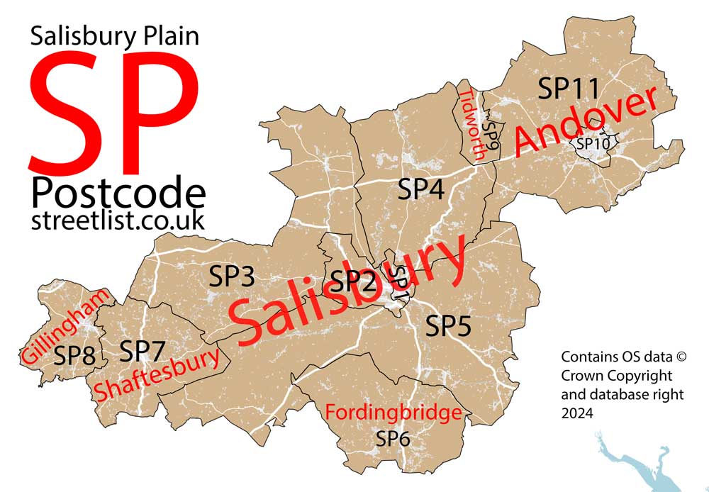
The SP postcode area represents a group of postal districts in the Salisbury area of the United Kingdom. The area code SP stands for the letters s and p in Salisbury Plain. SP has a population of 232,524 and covers an area of 1,675,515 hectares. Fun fact: 0.36% of the population of Great Britain lives in this area.
The postcode area falls within the following counties: Wiltshire (55.58%), Hampshire (31.23%), Dorset (13.20%).
Post Towns and Postcode Districts for the SP Postcode
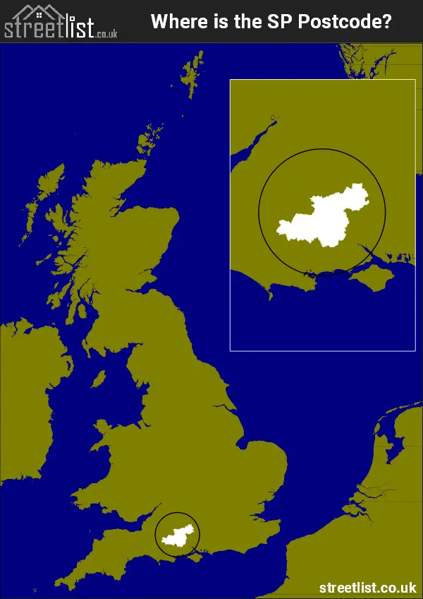
Where is the SP Postcode Area?
The SP Salisbury Plain Postcode is in the South West England. The postal area borders the following neighbouring postal areas: SN - Swindon, SO - Southampton, BH - Bournemouth, BA - Bath, RG - Reading and DT - Dorchester, and is located inland.
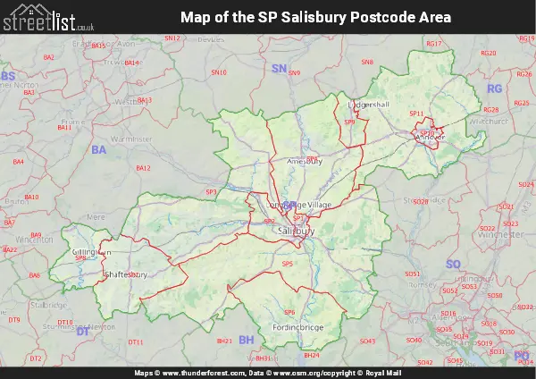
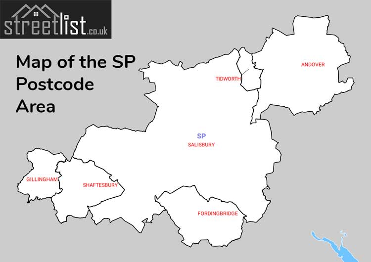
Map of the SP Salisbury Postcode Area
Explore the SP Salisbury postcode area by using our interactive map.
Postcode Districts within the SP Salisbury Postcode Area
There are 11 postcode districts within the Salisbury postcode area
A map showing the boundary of in relation to other areas
There are 8 towns within the Salisbury postcode area.
| Unit | Area² |
|---|---|
| Hectares | 1,675,515² |
| Miles | 6,469² |
| Feet | 180,350,759,085² |
| Kilometres | 16,755² |
Postal Delivery Offices serving the SP Salisbury Postcode Area
- Amesbury Delivery Office
- Andover Delivery Office
- Bulford Barracks Delivery Office
- Delivery Office Wnton Scale Payment Delivery Office
- Dinton Scale Payment Delivery Office
- East Knoyle Scale Payment Delivery Office
- Fordingbridge Delivery Office
- Fovant Scale Payment Delivery Office
- Gillingham Delivery Office (sp)
- Handley Scale Payment Delivery Office
- Hin Delivery Office N Scale Payment Delivery Office
- Landford Scale Payment Delivery Office
- Porton Scale Payment Delivery Office
- Salisbury Delivery Office
- Shaftesbury Delivery Office
- Tidworth Delivery Office
- Tisbury Scale Payment Delivery Office
- Whiteparish Scale Payment Delivery Office
- Woodfalls Scale Payment Delivery Office
Councils with Postcodes in SP
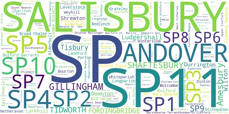
Towns and Villages within the SP Salisbury Postcode Area
- Abbotts Ann - village
- Alderbury - village
- Alderholt - village
- Allington - village
- Amesbury - town
- Amport - village
- Andover - town
- Andover Down - village
- Anna Valley - village
- Ansty - village
- Appleshaw - village
- Ashford - village
- Ashmore - village
- Barford St Martin - village
- Berwick St James - village
- Berwick St John - village
- Bishopstone - village
- Bodenham - village
- Boscombe - village
- Bourton - village
- Bowerchalke - village
- Breamore - village
- Britford - village
- Broad Chalke - village
- Buckhorn Weston - village
- Bulford - village
- Burcombe - village
- Cann - village
- Cann Common - village
- Charlton - village
- Charlton All Saints - village
- Chilmark - village
- Cholderton - village
- Compton Abbas - village
- Compton Chamberlayne - village
- Coombe Bissett - village
- Cripplestyle - village
- Croucheston - village
- Damerham - village
- Dinton - village
- Donhead St Andrew - village
- Donhead St Mary - village
- Downton - village
- Durrington - village
- East Cholderton - village
- East Dean - village
- East Grimstead - village
- East Knoyle - village
- East Stour - village
- East Tytherley - village
- Ebbesbourne Wake - village
- Enham Alamein - village
- Faccombe - village
- Farley - village
- Faulston - village
- Figheldean - village
- Firsdown - village
- Fonthill Bishop - village
- Fontmell Magna - village
- Ford - village
- Fordingbridge - town
- Forton - village
- Fovant - village
- Frogham - village
- Fyfield - village
- Gillingham - town
- Godshill - village
- Gomeldon - village
- Goodworth Clatford - village
- Grateley - village
- Great Durnford - village
- Great Shoddesden - otherSettlement
- Great Wishford - village
- Guy's Marsh - village
- Hale - village
- Hamptworth - village
- Hanging Langford - village
- Hartgrove - village
- Hatherden - village
- Haxton - village
- Hindon - village
- Homington - village
- Hurstbourne Tarrant - village
- Hyde - village
- Ibthorpe - village
- Idmiston - village
- Kimpton - village
- Kington Magna - village
- Landford - village
- Landfordwood - otherSettlement
- Larkhill - Settlement
- Lockerley - village
- Longparish - village
- Lopcombe - village
- Lover - village
- Lower Woodford - village
- Ludgershall - town
- Ludwell - village
- Martin - village
- Melbury Abbas - village
- Middle Winterslow - village
- Middle Woodford - village
- Middleton - village
- Milston - village
- Milton - village
- Milton on Stour - village
- Monxton - village
- Morgan's Vale - village
- Motcombe - village
- Netheravon - village
- Netherhampton - village
- Newton - otherSettlement
- Newton Tony - village
- Nomansland - village
- North Charford - village
- North Gorley - village
- Nunton - village
- Odstock - village
- Old Sarum - village
- Orcheston - village
- Palestine - village
- Penton Grafton - village
- Penton Mewsey - village
- Picket Piece - village
- Pitton - village
- Plaitford - village
- Porton - village
- Quarley - village
- Quidhampton - village
- Redlynch - village
- Rockbourne - village
- Salisbury - city
- Sandleheath - village
- Sandy Balls - village
- Semley - village
- Shaftesbury - town
- Sherfield English - otherSettlement
- Shipton Bellinger - village
- Shrewton - village
- Sixpenny Handley - village
- South Gorley - otherSettlement
- South Newton - village
- St Mary Bourne - village
- Stapleford - village
- Steeple Langford - village
- Stoford - village
- Stoke - village
- Stour Provost - village
- Stour Row - village
- Stuckton - village
- Sutton Mandeville - village
- Swallowcliffe - village
- Teffont Magna - village
- Thruxton - village
- Tidworth - town
- Tilshead - village
- Tinkers Cross - village
- Tisbury - village
- Tollard Royal - village
- Upper Chute - village
- Upper Clatford - village
- Upper Woodford - village
- Upton - village
- Vernham Dean - village
- Wardour - village
- West Amesbury - village
- West Dean - village
- West Grimstead - village
- West Stour - village
- West Tytherley - village
- West Winterslow - village
- Weyhill - village
- Whaddon - village
- Wherwell - village
- Whiteparish - village
- Whitsbury - village
- Wilton - town
- Winterbourne Dauntsey - village
- Winterbourne Earls - village
- Winterbourne Gunner - village
- Winterbourne Stoke - village
- Woodfalls - village
- Woodgreen - village
- Woodyates - village