This section of the site is all about the SO Postcode area, also known as the Southampton Postal Area. Explore links to the next level to learn more about specific postcode districts such as SO14.
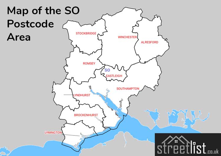
Map of the SO Postcode Area
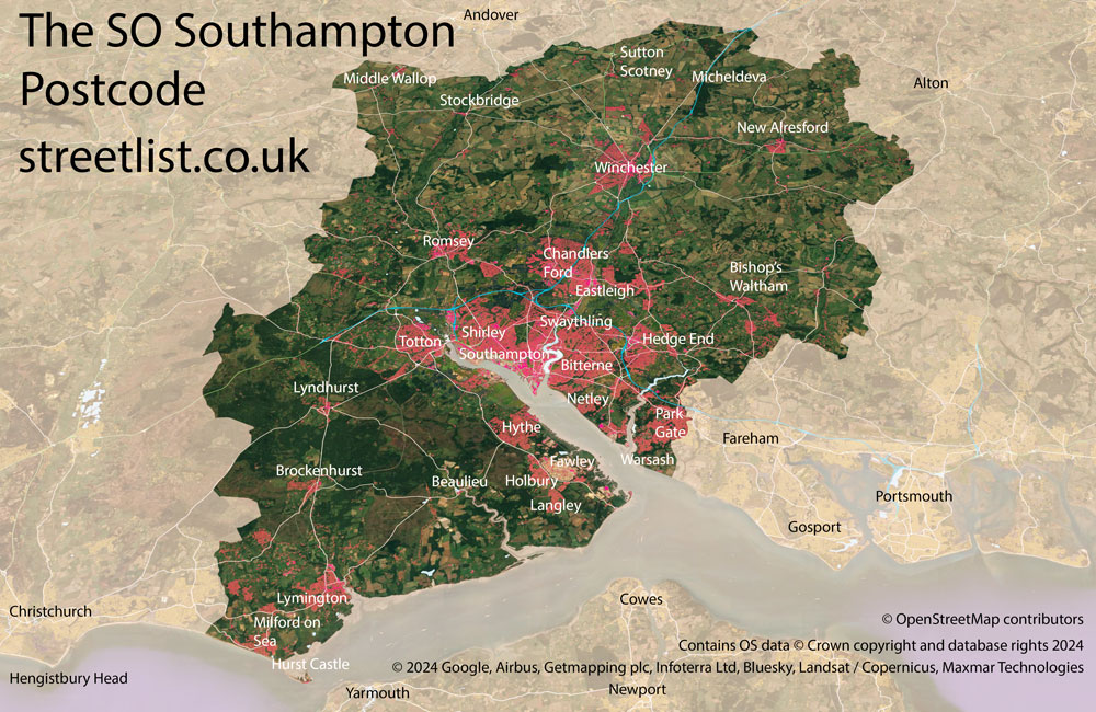
The SO postcode area represents a group of postal districts in the Southampton area of the United Kingdom. The area code SO stands for the letters s and o in SOuthampton. SO has a population of 665,193 and covers an area of 1,515,963 hectares. Fun fact: 1.02% of the population of Great Britain lives in this area.
The postcode area falls within the following counties: Hampshire (99.99%), Wiltshire (0.01%).
Post Towns and Postcode Districts for the SO Postcode
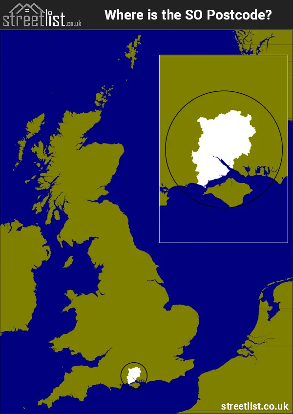
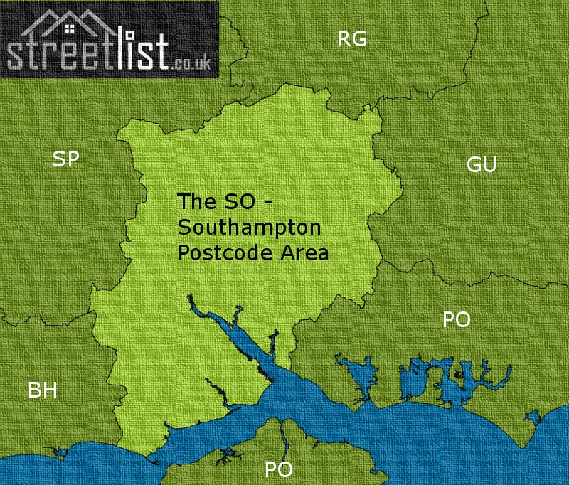
Where is the SO Postcode Area?
The SO Southampton Postcode is in the South East of England The postal area borders the following neighbouring postal areas: PO - Portsmouth, GU - Guildford, SP - Salisbury, BH - Bournemouth and RG - Reading, It also borders The Solent and The English Channel.
Map of the SO Southampton Postcode Area
Explore the SO Southampton postcode area by using our interactive map.
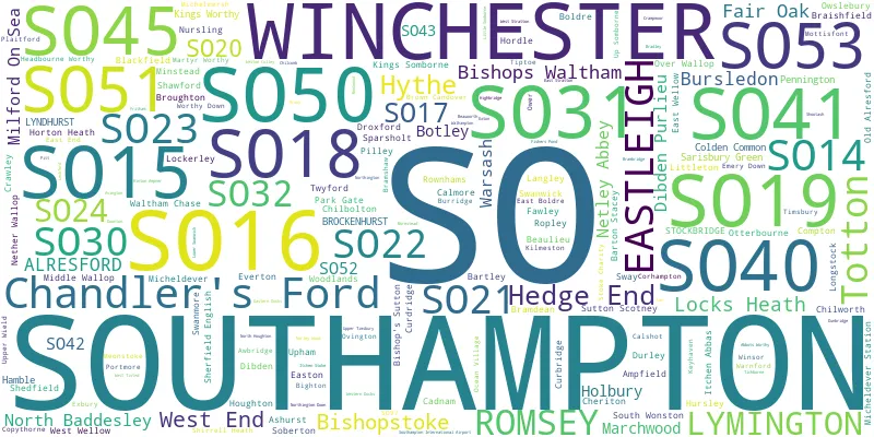
Postcode Districts within the SO Southampton Postcode Area
There are 23 postcode districts within the Southampton postcode area
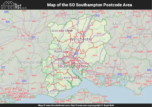
A map showing the boundary of in relation to other areas
There are 8 towns within the Southampton postcode area.
| Unit | Area² |
|---|---|
| Hectares | 1,515,963² |
| Miles | 5,853² |
| Feet | 163,176,741,357² |
| Kilometres | 15,160² |
Postal Delivery Offices serving the SO Southampton Postcode Area
- Alresford (so) Delivery Office
- Bishops Waltham Scale Payment Delivery Office
- Bitterne Manor
- Broughton Scale Payment Delivery Office
- Eastleigh Delivery Office
- Hedge End Delivery Office
- Hythe (so) Delivery Office
- Lymington Delivery Office
- Over Wallop Scale Payment Delivery Office
- Romsey Delivery Office
- Sarisbury Green Delivery Office
- Shirley (so) Delivery Office
- Stockbridge Scale Payment Delivery Office
- Swanmore Scale Payment Delivery Office
- Totton Delivery Office
- Waltham Chase Scale Payment Delivery Office
- Winchester Delivery Office
Councils with Postcodes in SO
Towns and Villages within the SO Southampton Postcode Area
- Abbots Worthy - village
- Abbotswood - village
- Ampfield - village
- Ashurst - village
- Avington - village
- Awbridge - village
- Balmerlawn - village
- Bartley - village
- Barton Stacey - village
- Beaulieu - village
- Bighton - village
- Bishop's Sutton - village
- Bishop's Waltham - town
- Bishopstoke - Village
- Blackfield - village
- Boldre - village
- Boorley Green - village
- Botley - village
- Bradley - village
- Braishfield - village
- Brambridge - village
- Bramdean - village
- Bramshaw - village
- Broadgate - village
- Brockenhurst - village
- Broughton - village
- Brown Candover - village
- Bull Hill - village
- Burridge - village
- Bursledon - village
- Butlocks Heath - village
- Cadnam - village
- Calshot - village
- Canada - village
- Chandler's Ford - Urban Area
- Cheriton - village
- Chilworth - village
- Chilworth Old Village - village
- Colden Common - village
- Compton - village
- Copythorne - village
- Corhampton - village
- Crampmoor - village
- Crawley - village
- Crowdhill - village
- Curdridge - village
- Dibden - village
- Dibden Purlieu - village
- Downton - village
- Droxford - village
- Dunbridge - village
- Durley - village
- Durley Street - village
- East Boldre - village
- East End - village
- East Stratton - village
- East Wellow - village
- Eastleigh - town
- Easton - village
- Emery Down - village
- Everton - village
- Exton - village
- Fair Oak - town
- Fawley - village
- Fisher's Pond - village
- Fritham - village
- Gilbert Street - otherSettlement
- Hamble-le-Rice - village
- Hardley - village
- Headbourne Worthy - village
- Hedge End - town
- Highbridge - village
- Hinton Ampner - village
- Holbury - village
- Hook Park Estate - village
- Hordle - village
- Horton Heath - village
- Houghton - village
- Hound - village
- Hursley - village
- Hythe - village
- Itchen Abbas - village
- Itchen Stoke - village
- Kentsboro - village
- Keyhaven - village
- Kilmeston - village
- King's Somborne - village
- Kings Worthy - village
- Langley - village
- Little Holbury - village
- Littleton - village
- Lockerley - village
- Locks Heath - village
- Longstock - village
- Lower Upham - village
- Lowford - village
- Lymington - town
- Lyndhurst - village
- Marchwood - village
- Martyr Worthy - village
- Meonstoke - village
- Micheldever - village
- Michelmersh - village
- Middle Wallop - village
- Milford on Sea - village
- Minstead - village
- Monkwood - village
- Mottisfont - village
- Nether Wallop - village
- Netley - village
- Netley Marsh - village
- New Alresford - town
- New Cheriton - village
- Newtown - otherSettlement
- Norleywood - village
- North Baddesley - village
- North Stoneham - otherSettlement
- Nursling - village
- Old Alresford - village
- Old Netley - village
- Otterbourne - village
- Over Wallop - village
- Owslebury - village
- Park Gate - village
- Pilley - village
- Plaitford - village
- Portmore - village
- Romsey - town
- Ropley - village
- Ropley Dean - village
- Rownhams - village
- Sandy Down - village
- Sarisbury - village
- Segensworth - village
- Setley - village
- Shawford - village
- Shedfield - village
- Sherfield English - otherSettlement
- Shirrell Heath - village
- Shootash - village
- Soberton - village
- Soberton Heath - village
- Soldridge - village
- South Down - village
- South Wonston - village
- Southampton - city
- Sparsholt - village
- Springvale - village
- Stockbridge - village
- Stoke Charity - village
- Sutton Scotney - village
- Swanmore - village
- Swanwick - village
- Sway - village
- Tichborne - village
- Timsbury - village
- Tiptoe - village
- Titchfield Common - Settlement
- Totton - town
- Twyford - village
- Up Somborne - village
- Upham - village
- Upper Wield - village
- Walhampton - village
- Waltham Chase - village
- Warnford - village
- Warsash - village
- West Wellow - village
- Whiteley - Urban Area
- Winchester - city
- Winsor - village
- Wonston - village
- Woodlands - village
- Worthy Down - village