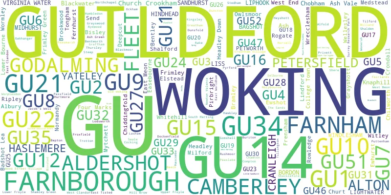
This section of the site is all about the GU Postcode area, also known as the Guildford Postal Area. Explore links to the next level to learn more about specific postcode districts such as GU1.
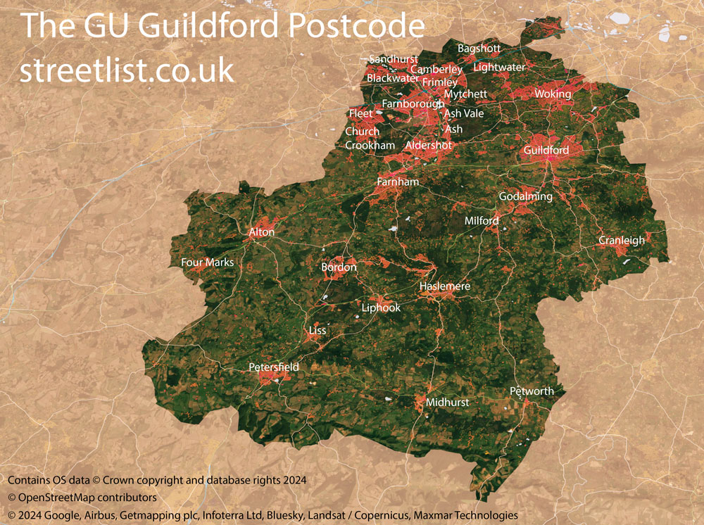
Maps of the GU Guildford Postcode
The GU postcode area represents a group of postal districts in the Guildford area of the United Kingdom. The area code GU stands for the letters g and u in GUildford. GU has a population of 725,368 and covers an area of 1,634,186 hectares. Fun fact: 1.12% of the population of Great Britain lives in this area.
The postcode area falls within the following counties: Surrey (59.48%), Hampshire (33.17%), West Sussex (4.86%), Berkshire (2.50%).
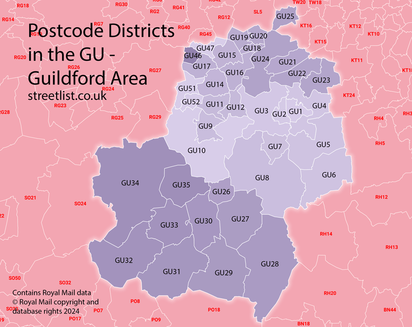
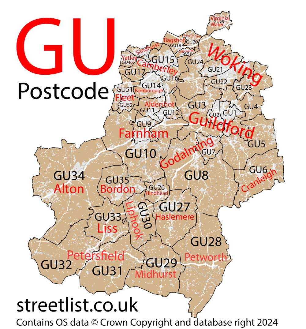
Post Towns and Postcode Districts for the GU Postcode
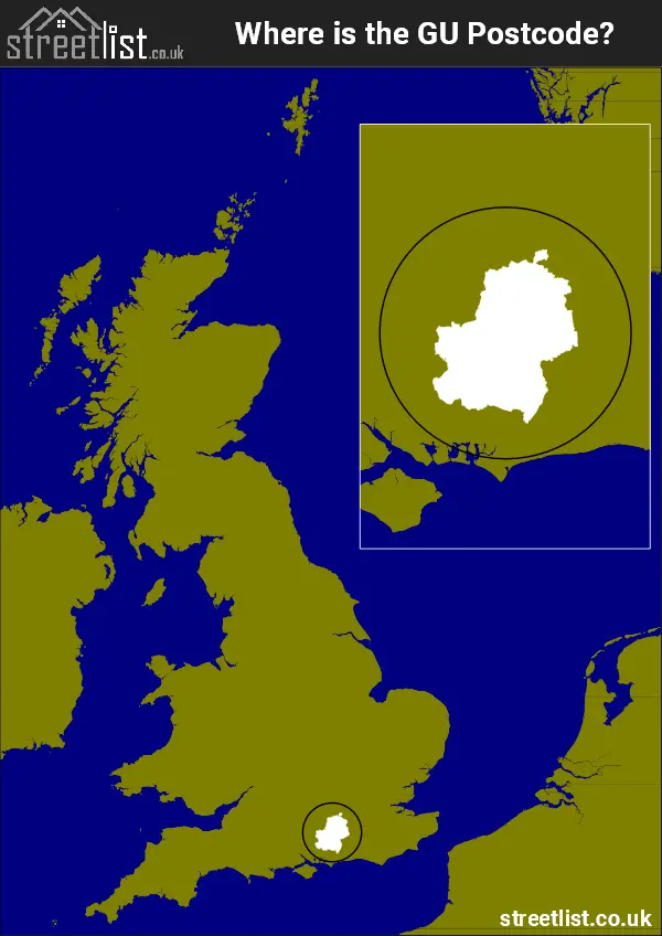
Where is the GU Postcode Area?
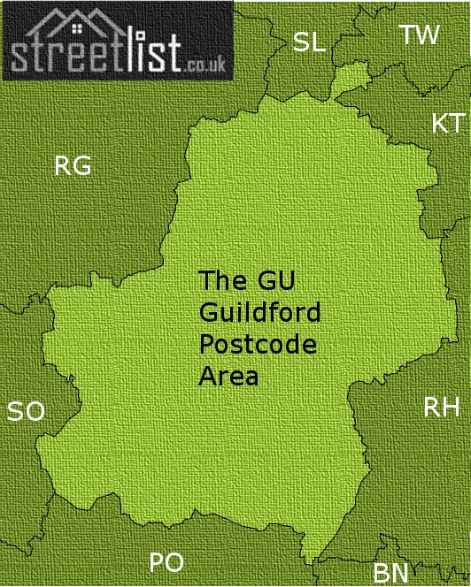
The GU Guildford Postcode is in the South East of England. The postal area borders the following neighbouring postal areas: PO - Portsmouth, SO - Southampton, SL - Slough, KT - Kingston upon Thames, BN - Brighton, RG - Reading, RH - Redhill and TW - Twickenham, and is located inland.
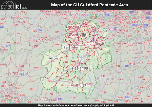
Map of the GU Guildford Postcode Area
Explore the GU Guildford postcode area by using our interactive map.
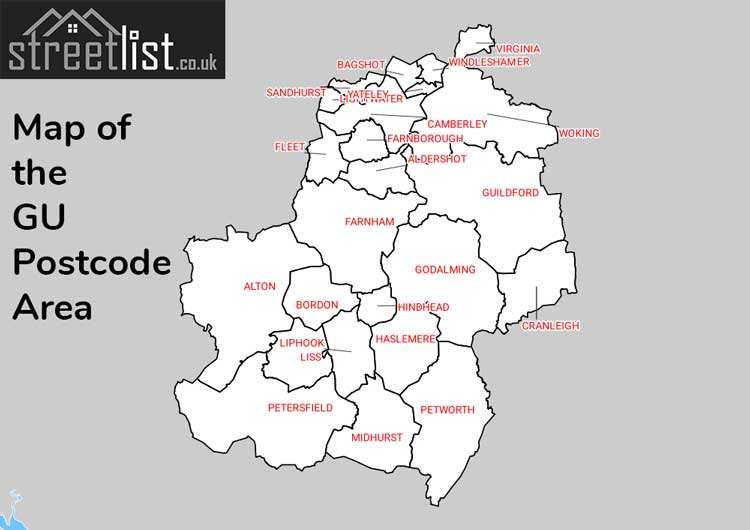
Postcode Districts within the GU Guildford Postcode Area
There are 38 postcode districts within the Guildford postcode area
A map showing the boundary of in relation to other areas
There are 19 towns within the Guildford postcode area.
| Unit | Area² |
|---|---|
| Hectares | 1,634,186² |
| Miles | 6,310² |
| Feet | 175,902,146,854² |
| Kilometres | 16,342² |
Postal Delivery Offices serving the GU Guildford Postcode Area
- Albury Scale Payment Delivery Office
- Aldershot Delivery Office
- Alton Delivery Office
- Bagshot Scale Payment Delivery Office
- Bordon Delivery Office
- Brookwood Scale Payment Delivery Office
- Camberley Delivery Office
- Chiddingfold Scale Payment Delivery Office
- Chobham Scale Payment Delivery Office
- Cranleigh Delivery Office
- Dunsfold Scale Payment Delivery Office
- Farnborough Delivery Office
- Farnham Delivery Office
- Fleet Delivery Office
- Godalming Delivery Office
- Gomshall Scale Payment Delivery Office
- Guildford Delivery Office
- Harting Scale Payment Delivery Office
- Haslemere Delivery Office
- Knaphill Delivery Office
- Lightwater Scale Payment Delivery Office
- Liphook Delivery Office
- Liss Delivery Office
- Midhurst Delivery Office
- Petersfield Delivery Office
- Petworth Delivery Office
- Ripley Scale Payment Delivery Office (gu)
- Sandhurst (gu) Delivery Office
- Shamley Green Scale Payment Delivery Office
- Virginia Water Delivery Office
- West End Scale Payment Delivery Office
- Windlesham Scale Payment Delivery Office
- Woking Delivery Office
Councils with Postcodes in GU
Towns and Villages within the GU Guildford Postcode Area
- Albury - village
- Aldershot - town
- Alfold - village
- Alfold Crossways - village
- Alton - town
- Arford - village
- Artington - village
- Ash - village
- Ash Green - village
- Ash Vale - village
- Badshot Lea - village
- Bagshot - village
- Beacon Hill - village
- Beech - village
- Bentley - village
- Bentworth - village
- Bepton - village
- Bepton Common - village
- Binscombe - village
- Binsted - village
- Bisley - village
- Blackheath - village
- Blackmoor - village
- Blacknest - village
- Blackwater - town
- Bordon - town
- Boundstone - village
- Bramley - village
- Bramshott - village
- Bramshott Chase - village
- Brick Hill - village
- Broadford - village
- Brook - village
- Brookwood - village
- Bucks Horn Oak - village
- Buriton - village
- Burntcommon - village
- Busbridge - village
- Byworth - village
- Camberley - town
- Castle Green - village
- Chawton - village
- Chiddingfold - village
- Chilworth - village
- Chobham - village
- Church Crookham - town
- Churt - village
- Cocking - village
- Compton - village
- Compton - village
- Conford - village
- Cramhurst - village
- Cranleigh - village
- Crondall - village
- Crookham Village - village
- Deepcut - village
- Dockenfield - village
- Donkey Town - village
- Dumpford - village
- Duncton - village
- Dunsfold - village
- Durfold Wood - village
- Easebourne - village
- East Clandon - village
- East Harting - village
- East Meon - village
- East Tisted - village
- East Worldham - village
- Elmbridge Village - village
- Elstead - village
- Elsted - village
- Elvetham Heath - village
- Empshott - village
- Enton Green - village
- Ewhurst - village
- Ewshot - village
- Fairlands - village
- Farley Green - village
- Farnborough - town
- Farncombe - village
- Farnham - town
- Fernhurst - village
- Fleet - town
- Flexford - village
- Four Marks - otherSettlement
- Frensham - village
- Frimley - town
- Frithend - village
- Godalming - town
- Gomshall - village
- Graffham - village
- Grayshott - village
- Grayswood - village
- Greatham - village
- Guildford - town
- Hale - village
- Hambledon - village
- Hammer - village
- Hammer Bottom - village
- Hampers Green - village
- Hascombe - village
- Haslemere - town
- Haslingbourne - otherSettlement
- Hawkley - village
- Hawley - village
- Headley - village
- Headley Down - village
- Heath End - village
- Heyshott - village
- High Cross - village
- Hill Brow - village
- Hindhead - village
- Hoe - village
- Hog Hatch - village
- Holt Pound - village
- Holybourne - village
- Hurtmore - village
- Hydestile - village
- Isington - village
- Jacobs Well - village
- Kingsley - village
- Kingsley Green - village
- Langrish - village
- Lasham - village
- Lickfold - village
- Lightwater - village
- Lindford - village
- Liphook - village
- Liss - village
- Lodsworth - village
- Lower Farringdon - village
- Lower Froyle - village
- Lurgashall - village
- Medstead - otherSettlement
- Midhurst - town
- Milford - village
- Mill Lane - village
- Milland - village
- Millbridge - village
- Mimbridge - village
- Mousehill - village
- Mytchett - village
- Newton Valence - village
- Normandy - village
- Norney - village
- Northchapel - village
- Nutcombe - village
- Nyewood - village
- Oakhanger - village
- Ockham - village
- Passfield - village
- Peaslake - village
- Peasmarsh - village
- Peper Harow - village
- Petersfield - town
- Petworth - town
- Pirbright - village
- Puttenham - village
- Pyle Hill - village
- Pyrford - village
- Pyrford Green - village
- Rake - village
- Ramsdean - village
- Ramsnest Common - village
- Ripley - village
- Rogate - village
- Rowledge - village
- Rowly - village
- Runfold - village
- Rushmoor - village
- Sandhills - village
- Sandhurst - town
- Sandy Cross - village
- Seale - village
- Selborne - village
- Send - village
- Send Marsh - village
- Shackleford - village
- Shalden - village
- Shalford - village
- Shamley Green - village
- Sheerwater - village
- Sheet - village
- Sheet's Heath - village
- Shere - village
- Shortfield Common - village
- Shortheath - village
- Soldridge - village
- South Harting - village
- Standford - village
- Stanford Common - village
- Stedham - village
- Steep - village
- Steep Marsh - village
- Stroud - village
- Stroude - village
- Sutton Green - village
- Terwick Common - village
- The Sands - village
- Thorncombe Street - village
- Thorpe Green - village
- Thursley - village
- Tilford - village
- Tilford Common - village
- Tillington - village
- Tongham - village
- Trotton - village
- Trumps Green - village
- Upper Eashing - village
- Upper Farringdon - village
- Upper Froyle - village
- Upper Hale - village
- Virginia Water - village
- Weavers Down - village
- Wentworth - otherSettlement
- West Byfleet - village
- West Clandon - village
- West End - village
- West Horsley - village
- West Lavington - village
- West Meon - village
- Weybourne - village
- Wheatsheaf Common - village
- Whitehill - village
- Willey Green - village
- Windlesham - otherSettlement
- Wishanger Common - otherSettlement
- Wisley - village
- Witley - village
- Woking - town
- Wonersh - village
- Wood Street Village - village
- Woodham - village
- Wormley - village
- Worplesdon - village
- Wrecclesham - village
- Wyke - village
- Yateley - town