
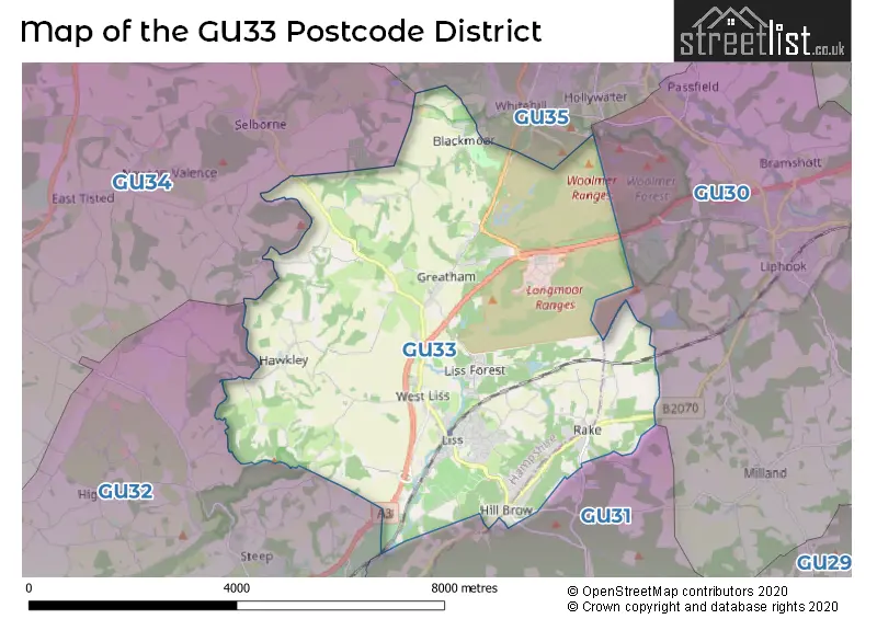
Map of the Postcode District
Explore the postcode district by using our interactive map.
Circles represent recorded crime; the larger the circle, the higher the crime rates.
Your support helps keep this site running!
If you enjoy using this website, consider buying me a coffee to help cover hosting costs.
The postcode district located in the GU Guildford postal area , GU33 has a population of 8,412 residents according to the 2021 England and Wales Census.
The area of the district is 18.55 square miles (48.04 square kilometers or 11,870.51 acres).
Where is the GU33 District?
To give you an idea where the district is located we have created the following table showing nearby towns.
Nearest Towns to GU33
| Town | Distance (miles) | Direction |
|---|---|---|
| Bordon | 3.86 | NNE |
| Petersfield | 4.41 | SSW |
| Alton | 7.02 | NNW |
| Haslemere | 8.20 | ENE |
| Midhurst | 8.49 | SE |
| Farnham | 11.39 | NNE |
| Horndean | 11.71 | SSW |
| New Alresford | 11.85 | W |
| Petworth | 13.47 | ESE |
| Aldershot | 14.23 | NNE |
| Havant | 14.71 | SSW |
| Emsworth | 14.86 | S |
| Godalming | 14.87 | NE |
| Fleet | 15.29 | N |
| Bishop's Waltham | 15.76 | WSW |
| Chichester | 16.32 | SSE |
| Basingstoke | 16.60 | NNW |
| Farnborough | 16.94 | NNE |
| Wickham | 16.99 | SW |
| Winchester | 18.20 | W |
The post town for this district is LISS.
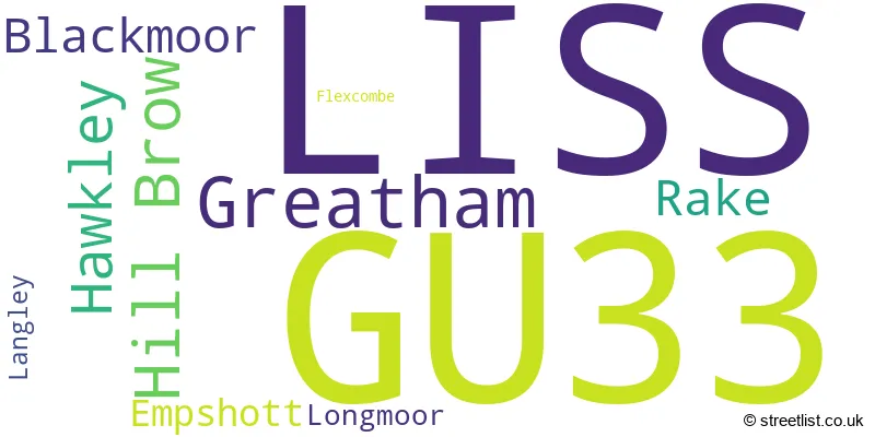
Postcode Information for District GU33 (Total Geographical Postcodes: 373)
| Location | Post Town | Sector | Number of Postcodes |
|---|---|---|---|
| LISS | LISS | GU33 7 | 165 |
| Hill Brow | LISS | GU33 7 | 46 |
| Greatham | LISS | GU33 6 | 42 |
| Rake | LISS | GU33 7 | 28 |
| LISS | LISS | GU33 6 | 27 |
| Hawkley | LISS | GU33 6 | 26 |
| Blackmoor | LISS | GU33 6 | 18 |
| Empshott | LISS | GU33 6 | 10 |
| Longmoor | LISS | GU33 6 | 6 |
| Langley | LISS | GU33 7 | 4 |
| Flexcombe | LISS | GU33 6 | 1 |
Retail and Shopping in GU33
Street
Town
Locality
Number of Shops
Central Postcode
View on Google Maps
STATION ROAD
LISS
29
GU33 7AA
View on Google Maps
HILL BROW ROAD
LISS
6
GU33 7RL
View on Google Maps
| Street | Town | Locality | Number of Shops | Central Postcode | View on Google Maps |
|---|---|---|---|---|---|
| STATION ROAD | LISS | 29 | GU33 7AA | View on Google Maps | |
| HILL BROW ROAD | LISS | 6 | GU33 7RL | View on Google Maps |
The primary settlement in the GU33 postcode district is Liss, which is located in the county of Hampshire in England. Other significant settlements in the district include Blackmoor, Empshott, Greatham, Hawkley, Longmoor, Hill Brow, Langley, and Rake. The significant Postal Town for the data is also Liss.
When it comes to local government, postal geography often disregards political borders. However, this district intersects the following councils: the district mostly encompasses the East Hampshire District (319 postal codes), and finally, the Chichester District area (31 postal codes).
The largest settlement in the GU33 postal code is LISS followed by Greatham, and Hill Brow.
The GU33 Postcode shares a border with GU34 (ALTON, Four Marks, Medstead), GU35 (BORDON, Whitehill, Lindford), GU31 (PETERSFIELD, Rogate, South Harting) and GU32 (PETERSFIELD, East Meon, West Meon).


Schools in the Sector
St Matthew's Church of England Aided Primary School
Phase: Primary
Address: Drift Road , Blackmoor , Liss
Postcode: GU33 6BN
Headteacher: Mrs K Pennicotte-Henrie (Headteacher)
Ofsted Rating: Good
Greatham Primary School
Phase: Primary
Address: Petersfield Road , Greatham , Liss
Postcode: GU33 6HA
Headteacher: Miss Jo Goman (Headteacher)
Ofsted Rating: Good
Rake CofE Primary School
Phase: Primary
Address: London Road , Rake , Liss
Postcode: GU33 7JH
Headteacher: Mr David Bertwistle (Headteacher)
Ofsted Rating: Good
Liss Junior School
Phase: Primary
Address: Hillbrow Road , Liss
Postcode: GU33 7LQ
Headteacher: Mrs Jilly Myers (Headteacher)
Ofsted Rating: Good
Liss Infant School
Phase: Primary
Address: Hillbrow Road , Liss
Postcode: GU33 7LQ
Headteacher: Mrs Jillian Myers (Headteacher)
Ofsted Rating: Requires improvement
Stations in the Sector
Liss
CRS Code: LIS
Operator: SW
Line: Portsmouth Direct line
Company: South Western Railway
Accessable Motorway Junctions
A3(M) J1
Average Driving Time from within the district: 12.99
Average Driving Distance: 11.66
Number of Postcodes that can access the Motorway Junction: 349
A3(M) J2
Average Driving Time from within the district: 14.01
Average Driving Distance: 12.71
Number of Postcodes that can access the Motorway Junction: 349
A3(M) J3
Average Driving Time from within the district: 15.79
Average Driving Distance: 14.58
Number of Postcodes that can access the Motorway Junction: 322
A3(M) J5
Average Driving Time from within the district: 17.34
Average Driving Distance: 16.24
Number of Postcodes that can access the Motorway Junction: 251
A3(M) J4
Average Driving Time from within the district: 17.86
Average Driving Distance: 15.71
Number of Postcodes that can access the Motorway Junction: 279
M3 J5
Average Driving Time from within the district: 25.79
Average Driving Distance: 17.25
Number of Postcodes that can access the Motorway Junction: 96
M3 J7
Average Driving Time from within the district: 27.28
Average Driving Distance: 19.35
Number of Postcodes that can access the Motorway Junction: 31
M3 J6
Average Driving Time from within the district: 28.05
Average Driving Distance: 19.63
Number of Postcodes that can access the Motorway Junction: 68
Weather Forecast for Petersfield
| Time Period | Icon | Description | Temperature | Rain Probability | Wind |
|---|---|---|---|---|---|
| 12:00 to 15:00 | Light rain shower (day) | 14.0°C (feels like 12.0°C) | 45.00% | SW 9 mph | |
| 15:00 to 18:00 | Cloudy | 14.0°C (feels like 13.0°C) | 35.00% | WSW 7 mph | |
| 18:00 to 21:00 | Clear night | 12.0°C (feels like 11.0°C) | 5.00% | WSW 4 mph | |
| 21:00 to 00:00 | Clear night | 11.0°C (feels like 10.0°C) | 1.00% | W 4 mph |
| Time Period | Icon | Description | Temperature | Rain Probability | Wind |
|---|---|---|---|---|---|
| 00:00 to 03:00 | Clear night | 9.0°C (feels like 8.0°C) | 4.00% | W 2 mph | |
| 03:00 to 06:00 | Fog | 8.0°C (feels like 8.0°C) | 17.00% | SW 2 mph | |
| 06:00 to 09:00 | Fog | 8.0°C (feels like 7.0°C) | 19.00% | S 2 mph | |
| 09:00 to 12:00 | Mist | 11.0°C (feels like 11.0°C) | 18.00% | SSE 2 mph | |
| 12:00 to 15:00 | Partly cloudy (day) | 15.0°C (feels like 14.0°C) | 30.00% | SSW 7 mph | |
| 15:00 to 18:00 | Partly cloudy (day) | 15.0°C (feels like 13.0°C) | 2.00% | S 9 mph | |
| 18:00 to 21:00 | Clear night | 11.0°C (feels like 10.0°C) | 0.00% | SSE 4 mph | |
| 21:00 to 00:00 | Clear night | 10.0°C (feels like 9.0°C) | 0.00% | SE 4 mph |
| Time Period | Icon | Description | Temperature | Rain Probability | Wind |
|---|---|---|---|---|---|
| 00:00 to 03:00 | Clear night | 11.0°C (feels like 10.0°C) | 1.00% | SE 7 mph | |
| 03:00 to 06:00 | Clear night | 11.0°C (feels like 9.0°C) | 0.00% | SE 7 mph | |
| 06:00 to 09:00 | Partly cloudy (night) | 11.0°C (feels like 9.0°C) | 1.00% | SSE 9 mph | |
| 09:00 to 12:00 | Cloudy | 13.0°C (feels like 11.0°C) | 5.00% | SSE 13 mph | |
| 12:00 to 15:00 | Partly cloudy (day) | 15.0°C (feels like 12.0°C) | 3.00% | S 13 mph | |
| 15:00 to 18:00 | Cloudy | 15.0°C (feels like 13.0°C) | 8.00% | S 11 mph | |
| 18:00 to 21:00 | Cloudy | 14.0°C (feels like 13.0°C) | 11.00% | SSE 11 mph | |
| 21:00 to 00:00 | Partly cloudy (night) | 15.0°C (feels like 13.0°C) | 17.00% | S 13 mph |
| Time Period | Icon | Description | Temperature | Rain Probability | Wind |
|---|---|---|---|---|---|
| 00:00 to 03:00 | Light rain shower (night) | 14.0°C (feels like 11.0°C) | 45.00% | SSW 13 mph | |
| 03:00 to 06:00 | Heavy rain | 12.0°C (feels like 10.0°C) | 71.00% | SSW 9 mph | |
| 06:00 to 09:00 | Light rain shower (night) | 11.0°C (feels like 9.0°C) | 31.00% | SSW 9 mph | |
| 09:00 to 12:00 | Sunny day | 12.0°C (feels like 9.0°C) | 8.00% | SSW 11 mph | |
| 12:00 to 15:00 | Light rain shower (day) | 13.0°C (feels like 10.0°C) | 31.00% | SW 13 mph | |
| 15:00 to 18:00 | Light rain shower (day) | 12.0°C (feels like 10.0°C) | 32.00% | SW 13 mph | |
| 18:00 to 21:00 | Clear night | 10.0°C (feels like 8.0°C) | 3.00% | WSW 11 mph | |
| 21:00 to 00:00 | Clear night | 9.0°C (feels like 6.0°C) | 1.00% | WSW 9 mph |
| Time Period | Icon | Description | Temperature | Rain Probability | Wind |
|---|---|---|---|---|---|
| 00:00 to 03:00 | Clear night | 8.0°C (feels like 6.0°C) | 1.00% | WSW 9 mph | |
| 03:00 to 06:00 | Clear night | 8.0°C (feels like 5.0°C) | 2.00% | SW 9 mph | |
| 06:00 to 09:00 | Clear night | 8.0°C (feels like 6.0°C) | 4.00% | SW 9 mph | |
| 09:00 to 12:00 | Sunny day | 10.0°C (feels like 8.0°C) | 8.00% | SW 9 mph | |
| 12:00 to 15:00 | Cloudy | 12.0°C (feels like 10.0°C) | 12.00% | SW 13 mph | |
| 15:00 to 18:00 | Cloudy | 13.0°C (feels like 10.0°C) | 14.00% | SW 11 mph | |
| 18:00 to 21:00 | Cloudy | 11.0°C (feels like 9.0°C) | 12.00% | SW 9 mph | |
| 21:00 to 00:00 | Clear night | 11.0°C (feels like 9.0°C) | 8.00% | WSW 9 mph |
| Postal Sector | Delivery Office |
|---|---|
| GU33 6 | Liss Delivery Office |
| GU33 7 | Liss Delivery Office |
| G | U | 3 | 3 | - | X | X | X |
| G | U | 3 | 3 | Space | Numeric | Letter | Letter |
Street List for the GU33 District
Current Monthly Rental Prices
| # Bedrooms | Min Price | Max Price | Avg Price |
|---|---|---|---|
| 2 | £1,200 | £1,200 | £1,200 |
| 3 | £1,500 | £3,250 | £2,313 |
Current House Prices
| # Bedrooms | Min Price | Max Price | Avg Price |
|---|---|---|---|
| 1 | £150,000 | £190,000 | £171,667 |
| 2 | £152,000 | £650,000 | £393,500 |
| 3 | £270,500 | £750,000 | £500,021 |
| 4 | £425,000 | £2,000,000 | £695,498 |
| 5 | £800,000 | £3,300,000 | £1,783,333 |
| 7 | £1,500,000 | £1,500,000 | £1,500,000 |
| 9 | £2,450,000 | £15,000,000 | £8,725,000 |
Estate Agents
| Logo | Name | Brand Name | Address | Contact Number |
|---|---|---|---|---|
 | Liss | Chapplins Estate Agents | 66 Station Road, Liss, GU33 7AA | 01730 771460 |
 | Petersfield | Homes Estate Agents | 18 College Street, Petersfield, GU31 4AD | 01730 776636 |
 | Liphook | Hamptons Sales | 10 The Square, Liphook, GU30 7AH | 01428 770949 |
 | Petersfield | Williams of Petersfield | 6-8 College Street, Petersfield, GU31 4AD | 01730 771281 |
 | Petersfield | Bourne | 2 Swan Street, Petersfield, Hampshire, GU32 3AD | 01730 771443 |
Yearly House Price Averages for the District
| Type of Property | 2018 Average | 2018 Sales | 2017 Average | 2017 Sales | 2016 Average | 2016 Sales | 2015 Average | 2015 Sales |
|---|---|---|---|---|---|---|---|---|
| Detached | £636,095 | 55 | £742,958 | 48 | £564,281 | 40 | £609,523 | 74 |
| Semi-Detached | £401,481 | 31 | £414,690 | 30 | £371,507 | 30 | £363,772 | 44 |
| Terraced | £359,050 | 10 | £319,444 | 18 | £317,878 | 29 | £332,250 | 39 |
| Flats | £258,706 | 17 | £275,667 | 9 | £159,793 | 12 | £232,923 | 13 |