The GU32 postcode district is a postal district located in the GU Guildford postcode area with a population of 12,266 residents according to the 2021 England and Wales Census.
The area of the GU32 postcode district is 34.02 square miles which is 88.11 square kilometres or 21,772.84 acres.
Currently, the GU32 district has about 555 postcode units spread across 3 geographic postcode sectors.
Given that each sector allows for 400 unique postcode combinations, the district has a capacity of 1,200 postcodes. With 555 postcodes already in use, this leaves 645 units available.
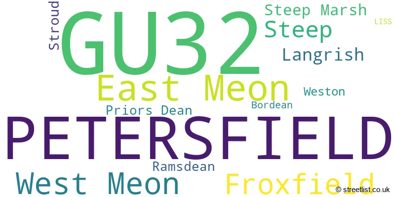
The largest settlement in the GU32 postal code is PETERSFIELD followed by East Meon, and West Meon.
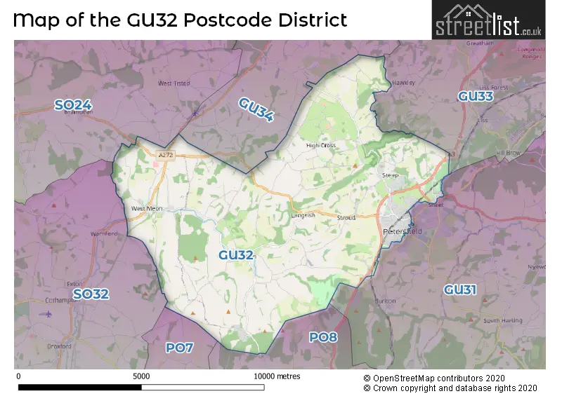
The GU32 Postcode shares a border with SO32 (Bishops Waltham, Botley, Swanmore), GU33 (LISS, Greatham, Hill Brow), GU34 (ALTON, Four Marks, Medstead), SO24 (ALRESFORD, Ropley, Cheriton), GU31 (PETERSFIELD, Rogate, South Harting) and PO8 (WATERLOOVILLE, Clanfield, Horndean).
The primary settlement in the GU32 postcode district is Petersfield, located in Hampshire, England. Other significant settlements in this area include East Meon, Froxfield, Langrish, Priors Dean, Ramsdean, Steep, Stroud, and West Meon. The postal town for this district is Petersfield.
For the district GU32, we have data on 4 postcode sectors. Here's a breakdown: The sector GU32 1, covers East Meon and West Meon and Froxfield in Hampshire. The sector GU32 2, covers Petersfield and Steep in Hampshire. The sector GU32 3, covers Petersfield in Hampshire. The sector GU32 9 is non-geographic. It's often designated for PO Boxes, large organisations, or special services.

Map of the GU32 Postcode District
Explore the GU32 postcode district by using our free interactive map.
When it comes to local government, postal geography often disregards political borders. However, for a breakdown in the GU32 District: the district mostly encompasses the East Hampshire District (515 postcodes), and finally, the Winchester District (B) area (46 postcodes).
Recent House Sales in GU32
| Date | Price | Address |
|---|---|---|
| 24/10/2023 | £925,000 | Ridge Common Lane, Steep, Petersfield, GU32 1AW |
| 22/09/2023 | £500,000 | Chapel Street, East Meon, Petersfield, GU32 1NR |
| 11/09/2023 | £515,000 | Barham Road, Petersfield, GU32 3EX |
| 08/09/2023 | £205,500 | Park Road, Petersfield, GU32 3DL |
| 07/09/2023 | £1,000,000 | The Cross, East Meon, Petersfield, GU32 1NN |
| 29/08/2023 | £440,000 | Borough Road, Petersfield, GU32 3LF |
| 25/08/2023 | £285,000 | Kings Road, Petersfield, GU32 3QY |
| 23/08/2023 | £670,000 | Trooper Bottom, Froxfield, Petersfield, GU32 1BH |
| 16/08/2023 | £570,000 | North Road, Petersfield, GU32 2AX |
| 15/08/2023 | £655,000 | Finchmead Lane, Petersfield, GU32 3PF |
Weather Forecast for GU32
Press Button to Show Forecast for East Meon
| Time Period | Icon | Description | Temperature | Rain Probability | Wind |
|---|---|---|---|---|---|
| 03:00 to 06:00 | Light rain | 6.0°C (feels like 3.0°C) | 62.00% | ENE 11 mph | |
| 06:00 to 09:00 | Light rain | 6.0°C (feels like 4.0°C) | 56.00% | NE 9 mph | |
| 09:00 to 12:00 | Cloudy | 9.0°C (feels like 6.0°C) | 8.00% | ENE 9 mph | |
| 12:00 to 15:00 | Cloudy | 12.0°C (feels like 10.0°C) | 9.00% | E 9 mph | |
| 15:00 to 18:00 | Cloudy | 12.0°C (feels like 10.0°C) | 13.00% | ENE 9 mph | |
| 18:00 to 21:00 | Light rain | 10.0°C (feels like 8.0°C) | 58.00% | NE 9 mph | |
| 21:00 to 00:00 | Light rain | 9.0°C (feels like 6.0°C) | 61.00% | NNE 11 mph |
Press Button to Show Forecast for East Meon
| Time Period | Icon | Description | Temperature | Rain Probability | Wind |
|---|---|---|---|---|---|
| 00:00 to 03:00 | Heavy rain | 8.0°C (feels like 5.0°C) | 83.00% | NNE 13 mph | |
| 03:00 to 06:00 | Heavy rain | 8.0°C (feels like 5.0°C) | 91.00% | NNE 11 mph | |
| 06:00 to 09:00 | Heavy rain | 7.0°C (feels like 4.0°C) | 86.00% | N 11 mph | |
| 09:00 to 12:00 | Light rain | 8.0°C (feels like 5.0°C) | 57.00% | NW 11 mph | |
| 12:00 to 15:00 | Light rain | 9.0°C (feels like 6.0°C) | 53.00% | WNW 11 mph | |
| 15:00 to 18:00 | Overcast | 10.0°C (feels like 8.0°C) | 17.00% | W 11 mph | |
| 18:00 to 21:00 | Cloudy | 10.0°C (feels like 8.0°C) | 6.00% | W 7 mph | |
| 21:00 to 00:00 | Partly cloudy (night) | 7.0°C (feels like 6.0°C) | 2.00% | SW 7 mph |
Press Button to Show Forecast for East Meon
| Time Period | Icon | Description | Temperature | Rain Probability | Wind |
|---|---|---|---|---|---|
| 00:00 to 03:00 | Clear night | 6.0°C (feels like 4.0°C) | 2.00% | SW 7 mph | |
| 03:00 to 06:00 | Clear night | 5.0°C (feels like 3.0°C) | 1.00% | SW 4 mph | |
| 06:00 to 09:00 | Sunny day | 7.0°C (feels like 5.0°C) | 1.00% | S 4 mph | |
| 09:00 to 12:00 | Partly cloudy (day) | 11.0°C (feels like 9.0°C) | 2.00% | S 11 mph | |
| 12:00 to 15:00 | Partly cloudy (day) | 12.0°C (feels like 10.0°C) | 1.00% | S 13 mph | |
| 15:00 to 18:00 | Sunny day | 12.0°C (feels like 10.0°C) | 2.00% | S 11 mph | |
| 18:00 to 21:00 | Sunny day | 11.0°C (feels like 9.0°C) | 1.00% | SSE 9 mph | |
| 21:00 to 00:00 | Clear night | 8.0°C (feels like 6.0°C) | 3.00% | SE 7 mph |
Press Button to Show Forecast for East Meon
| Time Period | Icon | Description | Temperature | Rain Probability | Wind |
|---|---|---|---|---|---|
| 00:00 to 03:00 | Clear night | 8.0°C (feels like 6.0°C) | 3.00% | ESE 9 mph | |
| 03:00 to 06:00 | Clear night | 8.0°C (feels like 6.0°C) | 3.00% | SE 9 mph | |
| 06:00 to 09:00 | Sunny day | 9.0°C (feels like 7.0°C) | 5.00% | ESE 9 mph | |
| 09:00 to 12:00 | Sunny day | 13.0°C (feels like 10.0°C) | 7.00% | SE 11 mph | |
| 12:00 to 15:00 | Sunny day | 14.0°C (feels like 12.0°C) | 7.00% | SE 11 mph | |
| 15:00 to 18:00 | Sunny day | 15.0°C (feels like 12.0°C) | 9.00% | SE 11 mph | |
| 18:00 to 21:00 | Sunny day | 13.0°C (feels like 12.0°C) | 9.00% | SE 9 mph | |
| 21:00 to 00:00 | Clear night | 11.0°C (feels like 9.0°C) | 7.00% | ESE 7 mph |
Where is the GU32 Postcode District?
The GU32 postcode district is located in Petersfield. It is situated near the towns of Liss to the North East (approximately 5.6 miles away), Waterlooville to the South (approximately 7.1 miles away), Alresford to the North West (approximately 9.3 miles away), and Alton to the North (approximately 9.9 miles away). In addition, the distance from Petersfield to the center of London is approximately 51.4 miles.
The district covers the post towns of LISS, PETERSFIELD.
The sector has postcodes within the nation of England.
The GU32 Postcode District is in the Central Hampshire region of Hampshire and Isle of Wight within the South East (England).
| Postcode Sector | Delivery Office |
|---|---|
| GU32 1 | Petersfield Delivery Office |
| GU32 2 | Petersfield Delivery Office |
| GU32 3 | Petersfield Delivery Office |
| G | U | 3 | 2 | - | X | X | X |
| G | U | 3 | 2 | Space | Numeric | Letter | Letter |
Current Monthly Rental Prices
| # Bedrooms | Min Price | Max Price | Avg Price |
|---|---|---|---|
| £1 | £1 | £1 | |
| 1 | £850 | £850 | £850 |
| 2 | £855 | £1,395 | £1,125 |
| 3 | £1,400 | £3,950 | £2,250 |
| 4 | £1,900 | £2,100 | £2,000 |
| 5 | £2,700 | £5,500 | £4,050 |
| 6 | £6,950 | £6,950 | £6,950 |
| 7 | £6,950 | £6,950 | £6,950 |
Current House Prices
| # Bedrooms | Min Price | Max Price | Avg Price |
|---|---|---|---|
| £80,000 | £125,000 | £102,500 | |
| 1 | £117,950 | £11,000,000 | £773,158 |
| 2 | £170,000 | £725,000 | £340,998 |
| 3 | £249,950 | £1,000,000 | £594,720 |
| 4 | £490,000 | £3,950,000 | £954,783 |
| 5 | £810,000 | £1,750,000 | £1,172,857 |
| 7 | £2,000,000 | £3,500,000 | £2,916,667 |
Estate Agents who Operate in the GU32 District
| Logo | Name | Brand Name | Address | Contact Number | Total Properties |
|---|---|---|---|---|---|
 | Petersfield | Homes Estate Agents | 18 College Street, Petersfield, GU31 4AD | 01730 776636 | 28 |
 | Petersfield | Bourne | 2 Swan Street, Petersfield, Hampshire, GU32 3AD | 01730 771443 | 13 |
 | Petersfield | Williams of Petersfield | 6-8 College Street, Petersfield, GU31 4AD | 01730 771281 | 12 |
 | Petersfield | Henry Adams | 24 Lavant Street, Petersfield, GU32 3EW | 01730 778582 | 10 |
 | Petersfield | Jacobs & Hunt Estate Agents | 26 Lavant Street Petersfield GU32 3EF | 01730 771354 | 10 |
| Type of Property | 2018 Average | 2018 Sales | 2017 Average | 2017 Sales | 2016 Average | 2016 Sales | 2015 Average | 2015 Sales |
|---|---|---|---|---|---|---|---|---|
| Detached | £692,114 | 59 | £635,973 | 68 | £743,553 | 53 | £654,415 | 47 |
| Semi-Detached | £470,627 | 50 | £426,245 | 55 | £408,536 | 42 | £427,420 | 41 |
| Terraced | £370,732 | 44 | £340,790 | 49 | £321,072 | 54 | £295,790 | 47 |
| Flats | £192,095 | 38 | £194,213 | 41 | £197,438 | 44 | £180,177 | 66 |